Lecompton Township, Douglas County, Kansas
| Lecompton Township | |
|---|---|
| Township | |
|
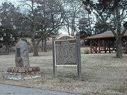
The Lecompton Rest Area along U.S. Highway 40 | |
 Location in Douglas County | |
| Coordinates: 39°01′45″N 095°24′36″W / 39.02917°N 95.41000°WCoordinates: 39°01′45″N 095°24′36″W / 39.02917°N 95.41000°W | |
| Country | United States |
| State | Kansas |
| County | Douglas |
| Area | |
| • Total | 35.53 sq mi (92.01 km2) |
| • Land | 34.65 sq mi (89.76 km2) |
| • Water | 0.87 sq mi (2.26 km2) 2.46% |
| Elevation | 974 ft (297 m) |
| Population (2000) | |
| • Total | 1,761 |
| • Density | 50.8/sq mi (19.6/km2) |
| GNIS feature ID | 0478815 |
Lecompton Township is a township in Douglas County, Kansas, USA. As of the 2000 census, its population was 1,761.
Lecompton Township was formed in about 1858.[1] It was named for the town of Lecompton which was the territorial capital of Kansas.
Geography
Lecompton Township covers an area of 35.53 square miles (92.0 km2) and contains one incorporated settlement, Lecompton. According to the USGS, it contains two cemeteries: Big Springs and Lecompton.
The streams of Coon Creek, Oakley Creek and Spring Creek run through this township.
Adjacent townships
- Kaw Township, Jefferson County (northwest)
- Kentucky Township, Jefferson County (north)
- Rural Township, Jefferson County (northeast)
- Wakarusa Township, Douglas County (east)
- Kanwaka Township, Douglas County (south)
- Tecumseh Township, Shawnee County (west)
Towns and settlements
Although these towns may not be incorporated or populated, they are still placed on maps produced by the county.
- Big Springs, located at 39°00′47″N 95°29′06″W / 39.01306°N 95.48500°W
- Grover, located at 39°03′24″N 95°28′27″W / 39.05667°N 95.47417°W
- Lecompton, located at 39°04′29″N 95°39′50″W / 39.07472°N 95.66389°W
Transportation
Major highways
- I-70, part of the Kansas Turnpike
- U.S. Highway 40
Points of interest
- The Scenic River Road. This old country road travels along the Kansas River from Tecumseh to Lake View via Lecompton.
References
- "Township of Lecompton". Geographic Names Information System. United States Geological Survey. 13 October 1978. Retrieved 2009-07-15.
External links
Municipalities and communities of Douglas County, Kansas, United States | ||
|---|---|---|
| Cities | 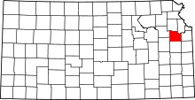 | |
| Unincorporated communities | ||
| Ghost towns | ||
| Townships | ||
This article is issued from Wikipedia - version of the 10/12/2016. The text is available under the Creative Commons Attribution/Share Alike but additional terms may apply for the media files.