Grover, Kansas
| Grover, Kansas | |
|---|---|
| Unincorporated community | |
|
An old barn just south of Grover. | |
 Grover, Kansas  Grover, Kansas | |
| Coordinates: 39°03′35″N 95°27′37″W / 39.05972°N 95.46028°WCoordinates: 39°03′35″N 95°27′37″W / 39.05972°N 95.46028°W | |
| Country | United States |
| State | Kansas |
| County | Douglas |
| Elevation | 853 ft (260 m) |
| Time zone | Central (CST) (UTC-6) |
| • Summer (DST) | CDT (UTC-5) |
| Area code(s) | 785 |
| GNIS feature ID | 484867[1] |

Grover is an unincorporated community in Douglas County, Kansas located 4 miles west of Lecompton and 6 miles east of Tecumseh. Grover had a post office from 1886 to 1895 and again from 1897 to 1899.[2]
References
- ↑ "US Board on Geographic Names". United States Geological Survey. 2007-10-25. Retrieved 2008-01-31.
- ↑ "Kansas Post Offices, 1828-1961, page 2". Kansas Historical Society. Retrieved 8 June 2014.
Municipalities and communities of Douglas County, Kansas, United States | ||
|---|---|---|
| Cities | 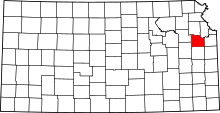 | |
| Unincorporated communities | ||
| Ghost towns | ||
| Townships | ||
This article is issued from Wikipedia - version of the 7/31/2016. The text is available under the Creative Commons Attribution/Share Alike but additional terms may apply for the media files.