Leebotwood
| Leebotwood | |
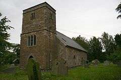 St Mary's Church, the parish church |
|
 Leebotwood |
|
| Population | 231 (2011)[1] |
|---|---|
| OS grid reference | SO 475 986 |
| Civil parish | Leebotwood |
| Unitary authority | Shropshire |
| Ceremonial county | Shropshire |
| Region | West Midlands |
| Country | England |
| Sovereign state | United Kingdom |
| Post town | Shrewsbury |
| Postcode district | SY6 |
| Dialling code | 01694 |
| Police | West Mercia |
| Fire | Shropshire |
| Ambulance | West Midlands |
| EU Parliament | West Midlands |
| UK Parliament | Shrewsbury and Atcham |
|
|
Coordinates: 52°34′59″N 2°46′30″W / 52.583°N 2.775°W
Leebotwood is a small village and civil parish in Shropshire, England. It is about 9 miles (14 km) south of Shrewsbury and 3.5 miles (5.6 km) north of Church Stretton.
Geography
The village is located on the A49 road, north of Church Stretton and south of the village of Dorrington. Nearby villages include Longnor (approximately 1½ miles to the north) and All Stretton which is 2 miles distant, between Leebotwood and Church Stretton.
Leebotwood is the only recognisable settlement in the parish. The Welsh Marches railway line runs through the parish, and there was once a small railway station, though today the nearest station is Church Stretton.
The Cound Brook passes through the village, flowing north towards Longnor.
The parish was part of the borough of Shrewsbury and Atcham, which existed 1973-2009. It continues to be part of the Parliamentary constituency of Shrewsbury and Atcham and in the area of Shropshire's unitary Council.
History
Leebotwood's parish church (St Mary's) dates from the 12th century and is a plain and simple building in comparison to its many neighbouring churches, including Church Stretton's St Laurence's Church. It is the burial place of the Corbett family of Longnor Hall, the local lords of the manor.
A valley between Leebotwood and Caer Caradoc was important as a thoroughfare dating right back to Roman times. The eastern boundary of the village was formed from the ancient route of Watling Street which is still visible today. Caer Caradoc to the south of Leebotwood rises to a height of 1506 ft and is said to be one of the last strongholds of the native chief "Caradoc" or "Caractacus" who held out against the Romans.
Etymology
The whole area was covered in thick forest, called "Botwde" (as the area was recorded in the Domesday Book) or "Bottewode" (as written in 1170)[2] until later in medieval times. Henry II granted this area to Augustinian canons with a chapel at Lega - hence the placename of "Lega in Bottewode"[2] (1170) and in modern times "Leebotwood". Nearby, in the parish of Church Stretton, is Botvyle, which also derives its name from the historic forest.
Present day
Local businesses
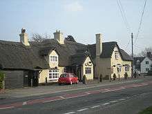
There is a thatched public house called "The Pound",[3] a tea rooms called "The Copper Kettle", a farm shop, and a village hall that offers internet use.
There are multiple "mixed farms", livestock farms and dairy farms around the village.
References
| Wikimedia Commons has media related to Leebotwood. |
| Unitary authorities | |
|---|---|
| Major settlements | |
| Rivers | |
| Canals | |
| Topics | |