Ozone Park–Lefferts Boulevard (IND Fulton Street Line)
| Ozone Park–Lefferts Boulevard | |||||||
|---|---|---|---|---|---|---|---|
| New York City Subway rapid transit station | |||||||
|
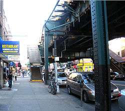
Station house at night, viewed from Lefferts Boulevard and Liberty Avenue | |||||||
| Station statistics | |||||||
| Address |
Lefferts Boulevard & Liberty Avenue Queens, NY 11419 | ||||||
| Borough | Queens | ||||||
| Locale | Richmond Hill | ||||||
| Coordinates | 40°41′10″N 73°49′27″W / 40.686203°N 73.82422°WCoordinates: 40°41′10″N 73°49′27″W / 40.686203°N 73.82422°W | ||||||
| Division | B (IND, formerly BMT) | ||||||
| Line | IND Fulton Street Line | ||||||
| Services |
A | ||||||
| Transit connections |
| ||||||
| Structure | Elevated | ||||||
| Platforms | 1 island platform | ||||||
| Tracks | 2 | ||||||
| Other information | |||||||
| Opened | September 25, 1915[1] | ||||||
| Former/other names |
Lefferts Avenue Lefferts Avenue–119th Street | ||||||
| Traffic | |||||||
| Passengers (2015) |
2,224,331[2] | ||||||
| Rank | 226 out of 422 | ||||||
| Station succession | |||||||
| Next north |
111th Street (local): A Rockaway Boulevard (express): no regular service | ||||||
| Next south |
(Terminal): A | ||||||
| |||||||
| |||||||


Ozone Park–Lefferts Boulevard is an elevated terminal station on the IND Fulton Street Line of the New York City Subway, located at the intersection of Lefferts Boulevard and Liberty Avenue in Queens. It serves as the terminus of the A route's Lefferts Boulevard branch. Despite its name, the station is not actually located in Ozone Park, but rather in the adjacent neighborhood of Richmond Hill.
History
Lefferts Boulevard was one of the six stations along Liberty Avenue in Queens, from 80th Street through Lefferts Boulevard, as well as the current three track elevated structure, built for the BMT Fulton Street Line in 1915 as part of BMT's portion of the Dual Contracts.[1][3] The connection to the BMT was severed on April 26, 1956, and the IND was extended east (railroad south) from Euclid Avenue via a connecting tunnel and new intermediate station at Grant Avenue, with the new service beginning on April 29, 1956.[3][4][5]
The station has gone by a number of different names. It opened as Lefferts Avenue.[1] A 1924 system map portrayed the station as "Lefferts Avenue", with "119th St." shown below the name in parentheses, and in a smaller print.[6] By 1948, "Lefferts" and "119" were shown in equal sizes,[7] and by 1959 the name was shown as "119 St–Lefferts".[8] Lefferts Avenue was later renamed Lefferts Boulevard, and the station appears as "Ozone Park–Lefferts Boulevard" on the current official map.[9]
In 2014, the Metropolitan Transportation Authority started a renovation project at the Lefferts Boulevard station. The renovated station will include 2 new ADA-accessible elevators (1 outside fare control from street level to mezzanine, and 1 more inside fare control from mezzanine to platform level) at the intersection of Liberty Avenue and Lefferts Boulevard.[10] This project is scheduled to be completed in December 2016.[11][12][13]
Station layout
| P Platform level |
Northbound | ← ← (No service: Rockaway Boulevard) |
| Island platform, doors will open on the left or right | ||
| Northbound | ← ← (No service: Rockaway Boulevard) | |
| M | Mezzanine | Fare control, station agent |
| G | Street Level | Exit/Entrance |
This station is one of the three southern terminals for the A train. Although this is a "south" terminal in railroad directions (considering the Eighth Avenue Line in Manhattan as north–south), Liberty Avenue underneath runs geographically WSW–ENE, so a train approach the "south" is actually traveling ENE, or more north than south.
This station has one island platform and two tracks. The tracks at the geographic north end of the station end at bumper blocks. At the geographic south end of the station, the line splits from two tracks to three. The middle express track is not currently used in revenue service.
The full-time entrance is at the geographic east end of the station. The exit at the opposite end has HEET access, with a mezzanine that leads to 116th street, with various offices and transit employee facilities. This mezzanine was renovated by an in-house contract in 1999. Tile colors here are light beige with dark green accents, installed in 1997.
References
- 1 2 3 "New Elevated Line Opened for Queens" (PDF). The New York Times. September 26, 1915. Retrieved September 28, 2007.
- ↑ "Facts and Figures: Annual Subway Ridership". Metropolitan Transportation Authority. Retrieved April 27, 2015.
- 1 2 Sparberg, Andrew J. (1 October 2014). From a Nickel to a Token: The Journey from Board of Transportation to MTA. Fordham University Press. ISBN 978-0-8232-6190-1.
- ↑ "First Leg of Rockaways Transit Opened at Cost of $10,154,702". nytimes.com. The New York Times. April 30, 1956. Retrieved 29 June 2015.
- ↑ Freeman, Ira Henry (June 28, 1956). "Rockaway Trains to Operate Today". nytimes.com. The New York Times. Retrieved 29 June 2015.
- ↑ "BMT Lines, Rapid Transit Division" (GIF). 1924. Retrieved November 9, 2007.
- ↑ "Rapid Transit Lines of the New York City Transit System" (GIF). 1948. Retrieved November 9, 2007.
- ↑ "Official New York City Subway Map and Station Guide" (GIF). 1959. Retrieved November 9, 2007.
- ↑ "Subway Map" (PDF). Metropolitan Transportation Authority. November 2016. Retrieved 2016-11-07.
- ↑ "MTA plans upgrade to Lefferts Boulevard A train station". QNS. Retrieved October 23, 2015.
- ↑ "Utica Av AC Station Becomes the 82nd Fully ADA Accessible Subway Station". MTA. May 23, 2014.
- ↑ "Elevator, subway upgrades slated for Lefferts Blvd stop". TimesLedger. Retrieved October 23, 2015.
- ↑ "Capital Dashboard | Home Page". web.mta.info. Retrieved 2016-07-29.
External links
| Wikimedia Commons has media related to Ozone Park – Lefferts Boulevard (IND Fulton Street Line). |
- nycsubway.org – IND Fulton Street Line: Lefferts Boulevard
- Station Reporter — A Lefferts
- The Subway Nut — Ozone Park–Lefferts Boulevard Pictures
- Lefferts Boulevard entrance from Google Maps Street View
- 116th Street entrance from Google Maps Street View