IND Eighth Avenue Line
| IND Eighth Avenue Line | |
|---|---|
|
The A, C, and E, which use the Eighth Avenue Line through Midtown Manhattan, have been colored blue since 1979. | |
| Overview | |
| Type | Rapid transit |
| System | New York City Subway |
| Termini |
207th Street South of High Street |
| Stations | 30 |
| Daily ridership | 1,007,933[1] |
| Operation | |
| Opened | 1932–1933 |
| Owner | City of New York |
| Operator(s) | New York City Transit Authority |
| Character | Underground |
| Technical | |
| Line length | 14 mi[2] (23 km) |
| Number of tracks | 2-4 |
| Track gauge | 4 ft 8 1⁄2 in (1,435 mm) |
| Electrification | 600V DC third rail |
The IND Eighth Avenue Line is a rapid transit line in New York City, United States, and is part of the B Division of the New York City Subway. Opened in 1932, it was the first line of the Independent Subway System (IND), and the Eighth Avenue Subway name was also applied by New Yorkers to the entire IND system.[3][4][5] Most of the line has four tracks, with one local and one express track in each direction, except for the extreme north and south ends, where only the two express tracks continue. The line is signaled as Line "A", with tracks A1, A3, A4, and A2 from west to east,[6] running from approximately 800 at the south end[7] to 1540 at the north end (measured in feet).[8][9]
The line runs from 207th Street in Inwood south to an interlocking south of High Street in Brooklyn Heights, including large sections under St. Nicholas Avenue, Central Park West, and Eighth Avenue. The entire length is underground, though the 207th Street Yard, which branches off near the north end, is on the surface. Flying junctions are provided with the IND Concourse Line, IND Sixth Avenue Line, and IND Queens Boulevard Line. Between 59th Street–Columbus Circle and 145th Street, the line can be referred as the Central Park West Line.
The whole line is served at all times by the A train, which runs express except during late nights. The C provides local service south of 168th Street while the A runs express. In addition, the B provides weekday local service and the D full-time express service between the Concourse Line (145th Street) and Sixth Avenue Line (59th Street–Columbus Circle) junctions, and the E runs local from the Queens Boulevard Line junction at 50th Street south to World Trade Center. The A, C, and E are colored vivid blue on signs because they run via Eighth Avenue through Midtown Manhattan, while the B and D are bright orange since they use the Sixth Avenue Line through Midtown Manhattan.[10]
Extent and service
The following services use part or all of the Eighth Avenue Line. The trunk line's bullets are colored vivid blue:
| Time period | Section of line | |||
|---|---|---|---|---|
| rush hours, middays, and evenings |
weekends | late nights | ||
| express | local | entire line | ||
| local | no service | between 145 St and 59 St | ||
| local | no service | south of 168 St | ||
| express | between 145 St and 59 St | |||
| local | between 50 St and WTC | |||
The Eighth Avenue begins as a two-track subway under Broadway at 207th Street in Inwood. A flying junction just to the south brings two tracks from the 207th Street Yard between the main tracks, merging after Dyckman Street. The subway leaves Broadway to pass under Fort Tryon Park to the north end of Fort Washington Avenue, which it follows to roughly 175th Street before turning southeast under private property.[9]
The small 174th Street Yard lies under Broadway, with two tracks exiting to the south under that roadway.[9] When the George Washington Bridge was designed in the 1920s, provisions were made for a lower deck that would carry these two tracks north from the yard and across the bridge, as well as two commuter rail tracks.[11][12] However, when the lower level was added in 1962, it instead carried a roadway.
The two main tracks from Fort Washington Avenue enter Broadway near 171st Street, running underneath the yard tracks in a double-decker tunnel. A few blocks later, the lower tracks separate to straddle the yard tracks at 168th Street. The local/express split begins here, with the local tracks coming from the yard and the express tracks coming from Inwood. Contrary to standard practice, the two local tracks are in the center and the two express tracks are on the outside. Except during late nights, the local service (C) ends at 168th Street, reversing direction on the yard tracks; the A runs to 207th Street at all times, express except during late nights. South of 168th Street, the express (outer) tracks lower below the local tracks, forming another double-decker tunnel, this time under St. Nicholas Avenue.[9]
North of 145th Street, the lower (express) tracks rise into the center, and the three-track IND Concourse Line enters St. Nicholas Avenue below the four-track Eighth Avenue Line. 145th Street is a two-level transfer station, with two island platforms on each level. To the south, the Concourse Line tracks rise and merge with the Eighth Avenue Line, carrying the B onto the local tracks and the D onto the express tracks. The resulting four-track line continues south under St. Nicholas Avenue and Eighth Avenue (Frederick Douglass Boulevard), which becomes Central Park West at 110th Street.[9]

Most of the line under Central Park West is built on two levels with both local tracks to the west and only local stations. The two northbound tracks are above the two southbound tracks. Approaching 59th Street–Columbus Circle, where Central Park West becomes Eighth Avenue, the subway again spreads out into a single four-track level.[9]
A flying junction south of 59th Street takes B and D trains east under 53rd Street, merging with two tracks from 57th Street to become the four-track IND Sixth Avenue Line. The two-track IND Queens Boulevard Line, also in 53rd Street, curves south into a lower level of the 50th Street station, and merges to the south, taking E trains onto the local tracks. An unused southbound-only lower level at 42nd Street–Port Authority Bus Terminal was formerly accessed only from the southbound track from the Queens Boulevard Line. Plans for the 7 Subway Extension required partially demolishing the lower level to make room for the new IRT Flushing Line tracks.[9]
The four-track line continues south under Eighth Avenue to 14th Street, where it turns southeast under Greenwich Avenue and south under Sixth Avenue, above the four-track IND Sixth Avenue Line. The two-level West Fourth Street–Washington Square station allows easy transfers between the two lines. Just to the south are track connections between the local tracks of each line, not used by current normal service patterns. The Sixth Avenue Line turns east into Houston Street after passing the connections.[9]
Canal Street, under Sixth Avenue, is the last normal four-track station on the line. Crossovers in each direction, beyond the station, take C and late night A trains between the local tracks to the north and the express tracks to the south. As the subway turns from Sixth Avenue into Church Street, the southbound local track passes under the express tracks, bringing E trains to the east. At this point, a bellmouth originally intended for the never-built IND Worth Street Line is present on the east side of the tunnel.[13][14][9] It has been proposed to use this to bring Long Island Rail Road Atlantic Branch trains to Lower Manhattan as part of the Lower Manhattan-Jamaica/JFK Transportation Project.[15]
The four tracks continue south under Church Street, with two separate but connected stations at World Trade Center at the end of the local tracks and Chambers Street on the express tracks. The two express tracks turn east under Fulton Street, crossing the East River through the Cranberry Street Tunnel into Cranberry Street in Brooklyn. Cranberry Street leads to High Street, from which the line turns south into Jay Street, straddled by the two-track IND Sixth Avenue Line from the Rutgers Street Tunnel. The Eighth and Sixth Avenue Lines end, becoming the IND Fulton Street Line and IND Culver Line, at crossovers (currently unused) allowing trains to switch between the two, south of High Street. Both the A and C trains continue along the Fulton Street Line.[9]
History
As early as March 1918, soon after the BMT Broadway Line opened to Times Square – 42nd Street, plans were being considered for an extension beyond the stubs at 57th Street (which was not yet open) to the Upper West Side and Washington Heights via Central Park West (Eighth Avenue).[16] On August 3, 1923, the New York City Board of Estimate approved the Washington Heights Line, an extension of the Broadway Line to Washington Heights. The line was to have four tracks from Central Park West at 64th Street under Central Park West, Eighth Avenue, Saint Nicholas Avenue, and private property to 173rd Street, and two tracks under Fort Washington Avenue to 193rd Street. South of 64th Street, one two-track line would connect to the Broadway Line stubs at 57th Street, and another would continue under Eighth Avenue to 30th Street at Penn Station, with provisions to continue downtown.[17][18]
Mayor John Hylan instead wanted to build an independent subway system, operated by the city. The New York City Board of Transportation gave preliminary approval to several lines in Manhattan, including one on Eighth Avenue, on December 9, 1924. The main portion of the already-approved Washington Heights Line - the mostly-four track line north of 64th Street - was included, but was to continue north from 193rd Street to 207th Street. South of 64th Street, the plan called for four tracks in Eighth Avenue, Greenwich Avenue, the planned extension of Sixth Avenue, and Church Street. Two tracks would turn east under Fulton Street or Wall Street and under the East River to Downtown Brooklyn.[19][20]
A groundbreaking ceremony was held at St. Nicholas Avenue and 123rd Street on March 14, 1925.[21] The majority of the Eighth Avenue Line, from Chambers Street north to 207th Street, was opened to the public just after midnight on September 10, 1932 after three days of operation on a normal schedule but without passengers.[22] The Cranberry Street Tunnel, extending the express tracks east under Fulton Street to Jay Street–Borough Hall in Brooklyn, was opened for the morning rush hour on February 1, 1933.[23] The Jay–Smith–Ninth Street Line opened on March 20, 1933, extending the line beyond Jay Street – Borough Hall.[24]
When the subway opened in 1932, express (A) and local (AA) trains served the line; expresses did not run during late nights or Sundays.[22] Expresses and late night/Sunday locals were sent south into Brooklyn in February 1933,[23] and, when the IND Concourse Line opened on July 1, 1933,[25] the C was added to the express service, while all locals became CC trains to the Concourse Line, forcing A trains to run local north of 145th Street.[26] The E was added to the local tracks south of 50th Street on August 19, 1933, when the IND Queens Boulevard Line opened.[27] The final major change came on December 15, 1940, when the IND Sixth Avenue Line opened. The AA was brought back as a non-rush hour local service, becoming the BB and switching to the Sixth Avenue Line at 59th Street–Columbus Circle during rush hours. The CC was kept only during rush hours to provide local service south past 59th Street. Additionally the C became a rush hour-only service, replaced by a full-time D over the express tracks between the Concourse and Sixth Avenue Lines.[28] This created the pattern that has remained to this day, with five services during normal hours: the A express, B part-time local via Sixth Avenue (then BB), C local (then AA and CC), D express via Sixth Avenue, and E local from Queens.
In 1953, the platforms were lengthened at Spring Street and Canal Street to 660 feet to allow E trains to run eleven car trains. The E and F began running eleven car trains during rush hours on September 8, 1953. The extra train car increased the total carrying capacity by 4,000 passengers. The lengthening project cost $400,000.[29]
A report for the Lower Manhattan Development Corporation looking at the Lower Manhattan Rail Link, an idea to connect Lower Manhattan with the Long Island Rail Road and JFK International Airport, presented several alternatives that would utilize the Cranberry Street Tunnel instead of building a new East River Tunnel. These alternatives would have required that C trains be rerouted through the Rutgers Street Tunnel.[30]
IND Worth Street Line
The IND Worth Street Line was a proposed major expansion of the IND Eighth Avenue Line. It was to come out of the main line's local tracks along Sixth Avenue/Church Street south of Canal Street and turn south-east into Worth Street. This route would travel in a two-track tunnel and probably stop at Foley Square (Lafayette and Centre Streets, on the north side of Federal Plaza), Chatham Square (with a possible connection to the Second Avenue Subway), Rutgers Street–East Broadway (with a connection to the IND Rutgers Street Line), and a station in the Lower East Side (possibly Pitt Street and Grand Street).
Crossing to Williamsburg, the line was to have stops at Havemeyer Street, South Fourth Street (connections to the IND Crosstown Line and a major junction to the IND Houston Street Line, the IND Utica Ave Line and a connection to the Rockaways). The Manhattan portion from the Church Street bellmouth to the East River would have been about two miles long.
Although the line never saw construction, evidence remains visible of a plan to build it. Vestiges of a bellmouth can be seen while traveling on the local tracks south of Canal Street. A large open space above the platform level at East Broadway was intended to become a two-track station. Above the north end of the Broadway station, a six-track station where the IND Worth Street and the Houston Street Lines would have converged can be envisioned.
Gallery
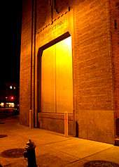
 The northern terminal, at 207th Street
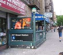
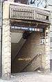 Entrance to 145th Street
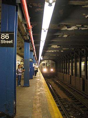 Lower-level local station on Central Park West (86th Street)
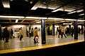 World Trade Center, the southern terminus for the local tracks
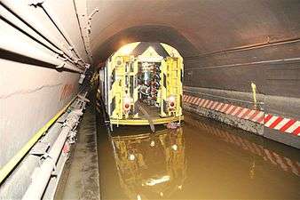 Pump train in the Cranberry Street Tunnel after Hurricane Sandy
Station listing
| Station service legend | |
|---|---|
| |
Stops all times |
| |
Stops all times except late nights |
| |
Stops late nights only |
| |
Stops weekdays only |
| |
Stops rush hours in the peak direction only |
| Time period details | |
| Neighborhood (approximate) |
Station | Tracks | Services | Opened | Transfers and notes | |
|---|---|---|---|---|---|---|
| Inwood | Inwood–207th Street | express | A |
September 10, 1932[22] | Bx12 Select Bus Service | |
| crossovers to connecting tracks to 207th Street Yard | ||||||
| Dyckman Street | express | A |
September 10, 1932[22] | |||
| connecting tracks to 207th Street Yard merge | ||||||
| Washington Heights | 190th Street | express | A |
September 10, 1932[22] | ||
| 181st Street | express | A |
September 10, 1932[22] | |||
| 175th Street | express | A |
September 10, 1932[22] | George Washington Bridge Bus Terminal | ||
| Local tracks begin in 174th Street Yard | ||||||
| 168th Street | all | A |
September 10, 1932[22] | IRT Broadway–Seventh Avenue Line (1 | ||
| 163rd Street–Amsterdam Avenue | local | A |
September 10, 1932[22] | |||
| 155th Street | local | A |
September 10, 1932[22] | |||
| Harlem | 145th Street | all | A |
September 10, 1932[22] | IND Concourse Line (B | |
| IND Concourse Line joins (B | ||||||
| 135th Street | local | A |
September 10, 1932[22] | |||
| 125th Street | all | A |
September 10, 1932[22] | M60 Select Bus Service to LaGuardia Airport | ||
| 116th Street | local | A |
September 10, 1932[22] | |||
| Upper West Side | Cathedral Parkway–110th Street | local | A |
September 10, 1932[22] | ||
| 103rd Street | local | A |
September 10, 1932[22] | |||
| 96th Street | local | A |
September 10, 1932[22] | |||
| 86th Street | local | A |
September 10, 1932[22] | M86 Select Bus Service | ||
| 81st Street–Museum of Natural History | local | A |
September 10, 1932[22] | |||
| 72nd Street | local | A |
September 10, 1932[22] | |||
| Midtown | 59th Street–Columbus Circle | all | A |
September 10, 1932[22] | IRT Broadway–Seventh Avenue Line (1 | |
| IND Sixth Avenue Line splits (B | ||||||
| 50th Street | local | A |
September 10, 1932[22] | IND Queens Boulevard Line (E | ||
| IND Queens Boulevard Line joins (E | ||||||
| 42nd Street–Port Authority Bus Terminal | all | A |
September 10, 1932[22] | IRT Broadway–Seventh Avenue Line (1 IRT Flushing Line (7 IRT 42nd Street Shuttle (S BMT Broadway Line (N Port Authority Bus Terminal M34A Select Bus Service | ||
| 34th Street–Penn Station | all | A |
September 10, 1932[22] | Penn Station: Amtrak, Long Island Rail Road, and New Jersey Transit M34/M34A Select Bus Service | ||
| Chelsea | 23rd Street | local | A |
September 10, 1932[22] | M23 Select Bus Service | |
| 14th Street | all | A |
September 10, 1932[22] | BMT Canarsie Line (L | ||
| Greenwich Village | West Fourth Street–Washington Square | all | A |
September 10, 1932[22] | IND Sixth Avenue Line (B Connection to PATH at Ninth Street | |
| local crossovers to/from IND Sixth Avenue Line (no regular service) | ||||||
| SoHo | Spring Street | local | A |
September 10, 1932[22] | ||
| TriBeCa | Canal Street | all | A |
September 10, 1932[22] | ||
| Financial District | Chambers Street | express | A |
September 10, 1932[22] | two parts of the same station; local tracks end IRT Broadway–Seventh Avenue Line (2 Connection to PATH at World Trade Center | |
| World Trade Center | local | E |
September 10, 1932[22] | |||
| Local tracks end | ||||||
| Fulton Street | express | A |
February 1, 1933[23] | formerly Broadway–Nassau Street IRT Broadway–Seventh Avenue Line (2 BMT Nassau Street Line (J IRT Lexington Avenue Line (4 Connection to BMT Broadway Line (N | ||
| continues through the Cranberry Street Tunnel | ||||||
| Brooklyn Heights | High Street | express | A |
June 24, 1933[31] | The line opened through here on February 1, 1933, but the station was not yet complete. | |
| Continues as the IND Fulton Street Line (A | ||||||
- *50th Street is accessible only in the southbound direction.
References
| Wikimedia Commons has media related to: |
The line and track descriptions use information in track maps on nycsubway.org, later published in:
- Marrero, Robert (2015-09-13). "469 Stations, 846 Miles" (PDF). B24 Blog, via Dropbox. Retrieved 2015-10-09.
- ↑ MTA. "Average weekday subway ridership". Retrieved 2 April 2014.
- ↑ "New Subway Link Opens Wednesday". New York Times. January 29, 1933. p. 3.
- ↑ "Old Jamaica Farm Divided for Homes". New York Times. October 8, 1939. p. 153.: "the property is near the Woodhaven Boulevard station of the Eighth Avenue subway"
- ↑ "Delaney Assails Transit Sitdowns". New York Times. January 31, 1943. p. 26.: "the Jamaica inspection barn of the Eighth Avenue Subway System, in Kew Gardens, Queens"
- ↑ Kramer, Frederick A. (1990-01-01). Building the Independent Subway. Quadrant Press. ISBN 9780915276509.
- ↑ General Signal Arrangement, Sta. 943+00 to Sta. 971+50 (PDF) (Map) (November 15, 1968 ed.). New York City Transit Authority Maintenance of Way Department.
- ↑ Joseph Brennan. "Abandoned Stations: Court St, and Hoyt-Schermerhorns Sts platforms". Retrieved 2007-04-19.
- ↑ Calculated from the length of 14 mil
- 1 2 3 4 5 6 7 8 9 10 Marrero, Robert (2015-09-13). "469 Stations, 846 Miles" (PDF). B24 Blog, via Dropbox. Retrieved 2015-10-09.
- ↑ Grynbaum, Michael M. "Take the Tomato 2 Stops to the Sunflower". City Room. Retrieved 2016-11-06.
- ↑ Tobin, Austin J. (May 10, 1960). "Addition to Bridge Upheld". New York Times. p. 36.
- ↑ "Across the Hudson by Rapid Transit". New York Times. January 30, 1984. p. A16.
- ↑ "100 Miles of Subway in New City Project". New York Times. September 16, 1929. p. 1.
- ↑ File No. 72, Drawing No. 58: Proposed Additional Rapid Transit Lines and Proposed Vehicular Tunnels (Map) (August 23, 1929 ed.). New York City Board of Transportation.
- ↑ Metropolitan Transportation Authority (October 2005). "Draft Long List of Alternatives" (PDF). Archived from the original (PDF) on 2011-08-05. Retrieved 2013-12-26.
- ↑ "Plan a New Subway on Upper West Side". New York Times. March 3, 1918. p. 27.
- ↑ "Two Subway Routes Adopted by City". New York Times. August 4, 1923. p. 9.
- ↑ "Plans Now Ready to Start Subways". New York Times. March 12, 1924. p. 1.
- ↑ "Hylan Subway Plan Links Four Boroughs at $450,000,000 Cost". New York Times. December 10, 1924. p. 1.
- ↑ Joseph B. Raskin (1 November 2013). The Routes Not Taken: A Trip Through New York City's Unbuilt Subway System. Fordham University Press. ISBN 978-0-8232-5369-2. Retrieved 12 August 2015.
- ↑ "Will Break Ground Today for New Uptown Subway". New York Times. March 14, 1925. p. 15.
- 1 2 3 4 5 6 7 8 9 10 11 12 13 14 15 16 17 18 19 20 21 22 23 24 25 26 27 28 29 30 31 "Gay Midnight Crowd Rides First Trains in New Subway". New York Times. September 10, 1932. p. 1.
- 1 2 3 "City Opens Subway to Brooklyn Today". New York Times. February 1, 1933. p. 19.
- ↑ "City Subway Adds a New Link Today". New York Times. March 20, 1933. p. 17.
- ↑ "New Bronx Subway Starts Operation". New York Times. July 1, 1933. p. 15.
- ↑ Station Guide, Independent City Owned Rapid Transit Railroad (Map) (ca. 1937 ed.). Courtesy of the Board of Transportation of N.Y.C., printed in the Clarified Telephone Directories (Red Books) for New York City. External link in
|title=(help) - ↑ "Two Subway Units Open at Midnight". New York Times. August 18, 1933. p. 17.
- ↑ "6th Ave. Tube Adds Two New Services". New York Times. December 5, 1940. p. 27.
- ↑ Ingalls, Leonard (August 28, 1953). "2 Subway Lines to Add Cars, Another to Speed Up Service". New York Times. Retrieved January 25, 2016.
- ↑ Lower Manhattan Development Corporation (2004). "Lower Manhattan Airport and Commuter Access Alternatives Analysis" (PDF). Retrieved 2008-03-19.
- ↑ "Jobs are Filled on All Subway Links". New York Times. June 25, 1933. p. 8.
External links
- IND 8th Avenue Line (www.nycsubway.org)
- NYCsubway.org - IND Second System
- NYCsubway.org - Roosevelt Avenue Terminal Station
- Abandoned Stations - IND Second System unfinished stations
- JoeKorNer - IND Second System (including a plan for a line to Staten Island)
| Services |
|      | ||||||
|---|---|---|---|---|---|---|---|---|
| Stations | ||||||||
| Divisions | ||||||||
| Other lists | ||||||||
| Expansion | ||||||||
| History | ||||||||
| Infrastructure | ||||||||
| Arts and culture | ||||||||
| Miscellaneous | ||||||||
| Other rapid transit in NYC | ||||||||
| Crossings of the East River | ||||
|---|---|---|---|---|
| ||||