Ozone Park, Queens
| Ozone Park | |
|---|---|
| Neighborhood of Queens | |
|
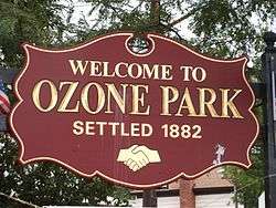
Ozone Park Welcome Sign | |
| Country | United States |
| State | New York |
| County | Queens |
| Population (2010) | |
| • Total | 21,376 (main section only) |
| Ethnicity (Census 2010) | |
| • White | 30.5% |
| • Black | 5.6% |
| • Hispanic | 34% |
| • Asian | 19.4% |
| • Other | 3.4% |
| Economics | |
| • Median income | $41,291 |
| ZIP code | 11416, 11417 |
| Area code(s) | 718, 347, 917 |
Ozone Park is a neighborhood located in the southwestern section of the borough of Queens, in New York City, New York, United States. It borders Woodhaven, Richmond Hill, Howard Beach, and City Line, Brooklyn.[1][2][3] Different parts of the neighborhood are covered by Queens Community Board 9 and 10.[4] The neighborhood is located in the Sixth congressional district, and is represented by Democrat Gregory Meeks.
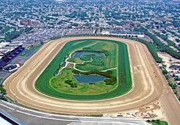
The northern border is Atlantic Avenue; the southern border is South Conduit Avenue, and the eastern border is 108th Street.[1] The western border is the county line with Brooklyn (mostly along Ruby and Drew Streets[5]). It is the home of the Aqueduct Racetrack, a popular spot for Thoroughbred racing. The neighborhood is known for its large Italian-American population.
The current ground level of Ozone Park is about four feet higher than the original ground level. Initially the avenues and cross streets were raised above ground level and then all of the basements were set on ground level and the land was back filled around the houses. The older houses that were at the original ground level now appear "sunken"; these can be observed on the south side of Sutter Avenue between 83rd and 85th streets.
Etymology
The name "Ozone Park" was chosen for the development to "lure buyers with the idea of refreshing breezes blowing in from the Atlantic Ocean to a park-like community,"[6] with "ozone" meaning not the alternate form of oxygen, but "fresh healthy air, especially from the sea."[7]
History
An area now part of Ozone Park that pre-dated that community was called "Centreville". It was founded in the 1840s and was centered around Centreville Street and the Centreville Community Church. Part of Ozone Park is still called "Centreville".[8] The church merged with the United Methodist Church of Ozone Park in 1957 and a new church, the Community Methodist Church of Ozone Park, was built at the Southeast corner of Sutter Avenue and Cross Bay Boulevard. It was completed for Christmas 1958. The old church and the property that surrounded it were sold to Aqueduct Racetrack and the old, historic church was torn down in mid-1959. The lot is still vacant as of 2013.
During the 1870s, an economic depression caused residents of New York City to look for better housing opportunities in the suburbs of Manhattan and Brooklyn, where housing would be cheaper. Two partners, Benjamin W. Hitchcock and Charles C. Denton, first began carving farmland into building lots. They were able to do this because of their wealth and substantial capital. Housing was first developed in the area after the Long Island Rail Road began service through the area in 1880 as part of its route from Long Island City to Howard Beach. Ozone Park was created and settled in 1882.[9]
Before the turn of the 20th century, there was an attempt to develop up to nine neighborhoods with the "park" title. Ozone Park was the only one of these neighborhoods that continues to exist, mostly because of the daily service at the now-defunct Ozone Park station on the Long Island Rail Road. The name persisted because of the many commuters who passed through the Ozone Park station and referred to it as an important landmark. The railroad station was also responsible for the increasing development of the neighborhood because the access to the railroad allowed people to get into the city easily, increasing its popularity among families looking to move into a suburb.
The final improvement to the local transit system was the Fulton Street Elevated train line at Liberty Avenue in 1914. In addition to this railroad station came the nickel fare, which was another major factor in the development of Ozone Park. The nickel fare gave residents the ability to travel anywhere along the railroad line for a set price of 5¢. This new fare was considered to be the "single most effective stimulus to home building" in the Ozone Park area because the real estate developers began buying up all the lots on either side of Liberty Avenue in hopes the new station would attract more people to want to live in Ozone Park.
Extensive housing construction occurred in the 1920s. The houses featured enclosed front porches, open back porches and stained-glass windows in the living rooms. Most of the houses were detached or semi-detached (very close to the neighboring house, but not sharing a common wall) built to roughly the same plan, with the living room, dining room and kitchen all in line and three bedrooms and a bath upstairs. The stairs were usually in the dining room. One of the builders was named Weyerman.
Prior to 1922, Woodhaven Boulevard was the only important north-south street in town. However, it ended at Liberty Avenue. Then officials decided to expand Woodhaven Boulevard all the way south to the Rockaways and finally opened it to traffic in 1925. This made Ozone Park more accessible by both bus and car. Since cars were also becoming more popular at that time, the land became much more valuable, leading to a construction boom in an attempt to fill any empty lot. Between 1921 and 1930, Ozone Park saw a population increase of over 180% from 40,000 to 112,950 people. With this extraordinary increase in population came the need for schools and sources of entertainment. In response to this demand came the construction of John Adams High School in 1930. This school was built just as the construction boom slowed down and right before the Great Depression. Furthermore, in 1925 the development of the Cross-Bay Movie Theatre gave residents the ability to go and see a show while also connecting with neighbors.
In 1996, a scandal broke surrounding two Ozone Park Jewish cemeteries, Mokom Sholom Cemetery and Bayside Cemetery, which share a coterminous tract bounded by 80th and 84th Streets and Liberty and Pitkin Avenues with Acacia Cemetery, which was not involved. Allegations of the re-using of graves of long-dead mostly infants and small children from the mid-to-late 19th Century, for re-sale to recent Russian Jewish immigrants, were made against the owners of Mokom Sholom, and both it and Bayside had also been ravaged (Mokom Sholom more) by a combination of vandals, grave-robbers, and self-styled necromancers. The former was exposed by WABC-TV Channel 7 in a series of news items, while the latter spawned philanthropic efforts to repair the damage.
One infamous area of Ozone Park is known as "The Hole", and includes the area bounded by 75th (Ruby) Street, South Conduit Avenue, 78th Street and Linden Boulevard. It is named as such because the houses in this area were built below grade. In the 1930s, the city of New York decided to install sewers and sewer lines in Ozone Park to stop the serious flooding that was a major problem. In order to install the sewers, the houses had to be raised almost an entire floor. Owners were given a stipend to raise their homes but some chose not to do so. The first floor in some of the non-raised homes subsequently became basements. And even today, there are still a few homes that remain below grade.
Demographics
Since its beginnings, Ozone Park has been largely populated by various groups of immigrants. The first wave were French immigrants associated with a pot factory on Atlantic Avenue. Germans and the Irish made up a large part of Ozone Park in the late 19th century and early 20th century. Eventually, the Italians, who are one of the largest ethnic groups in the neighborhood (giving it the name "the Little Italy of Queens"), started to migrate into Ozone Park from East New York, Brooklyn. Most of the current Italians in the neighborhood are originally from Brooklyn. Fears of changing neighborhoods caused a stir amongst the Italians that caused them to move into Ozone Park, which at the time was mostly Germans and Irish who had migrated themselves from neighboring East New York. A significant Polish population also developed based around Saint Stanislaus Bishop and Martyr Roman Catholic Church and its associated elementary school.
Census data from the early years shows how Ozone Park was a sparsely populated neighborhood because of the lack of transportation. By 1915, the Fulton Street Line opened, connecting Ozone Park with the rest of New York City, thus starting the enormous influx by the Italians. Ozone Park then formed many smaller sub-neighborhoods with specific identities. The Tudor Village section, which is still known by this name, was located on the south bordered by Pitkin Avenue and North Conduit Avenue and from east to west Cross Bay Boulevard and North Conduit Avenue. Centreville, which also still uses this name, is bordered by Aqueduct on the east, Cross Bay Boulevard on the west, North Conduit Avenue on the south, and Rockaway Boulevard on the north. Liberty Heights, which is only known by the old-timers, is a triangular area bordered by Liberty Avenue on the south, diagonal-running 101st Avenue (Jerome Avenue) from the southwest to the northeast, and Woodhaven Boulevard to the east. Balsam Village, which is also known by the old-timers, was named after Balsam Farms, which sold off parcels of land for development, and is bordered by Liberty Avenue on the north, 84th Street on the west, and Cross Bay Boulevard on the east.
In the 1980s, Ozone Park's 106th police precinct became the source and scene of several police brutality incidents, including April 17, 1985's stun gunning of high schooler Mark Davidson, who was arrested on marijuana possession charges.
At the turn of the 21st century immigrants from Latin America, South Asia (Bangladesh), the West Indies, and South America (Indo-Guyanese & Indo-Surinamese) moved in, adding a diverse atmosphere to the neighborhood, which is especially apparent along 101st Avenue and Liberty Avenue near the neighborhood's border with Richmond Hill.[10] The neighborhood remains largely Italian-American; however, these new arrivals have made Ozone Park become one of the fastest-growing and most ethnically diverse neighborhoods in New York City. Aside from these larger groups, there is a large Hispanic population in Ozone Park, mainly concentrated in the northern portion of the neighborhood near the Woodhaven border, and an African-American minority, spread throughout the neighborhood.
Residents vary from working-class to middle-class families, who own or rent private homes on the neighborhood's tree-lined residential streets. There are pockets of wealthier areas in the southern part of the neighborhood close to the Belt Parkway.
Subsections
South Ozone Park
South Ozone Park is a neighborhood in Ozone Park, but despite its name, South Ozone Park is mostly in the east of the neighborhood of Ozone Park.[11] It extends from the Aqueduct Racetrack eastward to the Van Wyck Expressway.[11] Its main thoroughfare is Rockaway Boulevard. The neighborhood is part of Queens Community Board 10.[4]
South Ozone Park is home to a more diverse population of about 45,498, with many Indians, Pakistani, Guyanese, Trinidadian, and Blacks living in the area, in addition to the area's longtime Italian-American population; Italian-Americans are most prevalent in the southern and western areas in the neighborhood near the Conduit. There has been a recent surge of development in South Ozone Park that rivals many of the surrounding communities in terms of home value. Rockaway Boulevard is South Ozone Park's main business strip. There is also a high concentration of small businesses along Liberty Avenue in nearby Richmond Hill. In 2000, the population was 7.8% white, 45.7% Asian Indian, 12.7% Hispanic, 12.8% non-Indian Asian, and 25.6% black. The Median income is $80,000, and the ZIP code is 11420.
Tudor Village
The neighborhood, in western Ozone Park, is extremely small, consisting of approximately two hundred and fifty homes; it spans only five residential streets and two avenues. Its population consists mostly of Italian Americans. Its residents consist of approximately six hundred people, mostly families. Most of its inhabitants have lived there for many years. The village was incorporated in the late 1800s and has since flourished. Tudor Village hosts suburban tree-lined streets with what is referred to as the "Tudor Malls" in its center, boasting floral arrangements throughout. The village is also home to Tudor Park, a 20-acre (81,000 m2) recreational park which features a baseball field, racquetball courts, picnic area, and a fountain as well as a play area with slides, swings and almost everything else one would expect to find in a suburban park. Located on the southeast end of the village are another baseball field and benches and shaded areas for resting. Tudor Village is on the border of Howard Beach.
Transportation
Numerous New York City Bus routes stop in the area, such as the Q7, Q8, Q10, Q11, Q21, Q24, Q37, Q40, Q41, Q52, Q53, Q112. The B15 runs through the neighborhood without stopping.[12] The New York City Subway's IND Fulton Street Line (A train) and IND Rockaway Line (A train) also run through the neighborhood.[13]
Schools

Public schools
- P.S. 45 The Clarence E. Witherspoon School, at 126-28 150th Street, serves grades K-6.
- P.S. 63 Old South School
- P.S. 64 Joseph P. Addabbo School
- P.S. 65 The Raymond York Elementary School
- P.S. 108 - Captain Vincent G. Fowler is an elementary school that educates an average of 1400 students from Pre K-5th Grade. It is located across from the Aqueduct Racetrack.
- P.S 121 is located at 126-10 109th Avenue.
- Middle School 137 America's School-Heroes
- Junior High School 202 R. H. Goddard
- P.S. 124 Osmond A Church
- Junior High School 210 Elizabeth Blackwell
- Virgil I Grissom, J.H.S. 226, Rockaway Blvd and 122nd Street. This middle school is named for the late astronaut, it features Grades 6-8 and specializes in several areas of general education practices. It is a zoned school nestled in an area of a diverse population. Virgil I. Grissom contains violence, but Rushell White has worked on this problem and started creating programs for the children.
- P.S. 316 (Opened September 2014)
- Robert H Goddard High School Of Technology and Communications, Q308
- John Adams High School, Q480
- High School for Construction Trades, Engineering and Architecture, Q650
Private schools
- St Elizabeth's RC Elementary
- St Mary Gate of Heaven RC Elementary
- Divine Mercy Catholic Academy (originally Nativity B.V.M. and St. Stanislaus Schools, which were combined renamed in 2007)
- Little Dolphin Pre-School
- Our Lady's Catholic Academy Our Lady’s Catholic Academy is a diverse, child-centered Catholic elementary school with 2 campuses that serves the South Ozone Park community. The first school campus located on 126th Street and Rockaway Boulevard, was founded in September 2009, under the direction and guidance of the Board of Directors. The school expanded to a second campus in September 2012 and is located on 128th Street and 111th Avenue [14]
- Our Lady of Perpetual Help School is the parish school for the church of the same name. It is located on 115th Street and is within the Roman Catholic Diocese of Brooklyn. Established on September 12, 1927, it educates in grades PK-8. The principal is Mrs. Frances DeLuca.
- Al-Ihsan Academy, established in 1989 to provide education to the burgeoning Muslim populace of Ozone Park
Closed schools
- Our Lady of Wisdom RC Secondary
Notability
In popular culture
Ozone Park has served as the setting and subject of numerous media works.
Film:
- A Bronx Tale (1993) features a scene set at Aqueduct Racetrack.
- A Shock to the System (1990) contains a scene filmed in the old Aqueduct Racetrack station.
- Boss of Bosses (2001, starring Chazz Palminteri) features a scene with John Gotti in Ozone Park at the Bergin Hunt and Fish Club.
- Goodfellas (1990) is an Academy Award-winning gangster film that takes place in and around Ozone Park.
- Holy Rollers (2010) features external shots of the Gold and Zimmerman houses.
- Lucky Number Slevin (2006) contains a scene at the beginning, wherein the father and son are at Aqueduct Racetrack.
- This Is My Life (1992) starring Julie Kavner as Dottie Ingels living in Ozone Park
Television:
- All in the Family's (1970s TV sitcom) principals, Archie and Edith Bunker, had cousins who lived in Ozone Park.
- Getting Gotti (1994 TV film starring Lorraine Bracco) is based on a real life woman, Diane Giacalone, who grew up in Ozone Park and through the years first-handedly watched Gotti rise to power on the streets of Ozone Park; she eventually became an Assistant US Attorney and built up a case against him.
- The The King Of Queens TV sitcom often contains scenes in which the old United Artists Cross Bay movie theatre on Rockaway Boulevard can be seen.
- The Perfect Crimes History Channel documentary features the Lufthansa heist and discusses the Lucchese crime family crews living, killing and running businesses in Ozone Park.
- The Sopranos character, Rusty Millio (played by Frankie Valli), lives in Ozone Park, as revealed in the episode "Live Free or Die".
Notable events
- Pope John Paul II celebrated mass for 75,000 people at Ozone Park's Aqueduct Racetrack in October 1995.
Notable residents

Notable current and former residents of Ozone Park include:
- Ray Abruzzo - actor (e.g., The Sopranos)
- Joseph Patrick Addabbo - Congressman; P.S. 64 was named after him.[15]
- Joseph Addabbo, Jr., member of the New York State Senate from the 15th District and of the New York City Council from the 32nd Council District. He is the son of Joseph Patrick Addabbo.[15]
- Ray Anthony (Slesinski) - author, speaker, innovator.
- Pedro Beato - relief pitcher of the Baltimore Orioles
- Charles Camarda - astronaut, Mission Specialist on STS-114
- The Capris - 1950s Doo Wop group.[16]
- Gerald Edelman (1929-) - 1972 winner of the Nobel Prize in Physiology or Medicine.[17]
- Elizabeth Eden (1946–1987) - real life character of Leon from the 1975 film Dog Day Afternoon.[18]
- Peter Facinelli (born November 26, 1973) - actor
- John Frascatore (1970-) - baseball player[19]
- John Gotti (1940–2002) - Mafia boss (headed the Gambino crime family)[20]
- Neal Heaton (1960-) - MLB baseball pitcher
- Carol Heiss (1940-) - Olympics figure skater[21]
- Father Rob Keighron (1980-) - Roman Catholic priest, co-host/co-producer of The Catholic Guy[22]
- Jack Kerouac (1922–1969) - writer. Born in Lowell, Massachusetts, he lived in Ozone Park with his parents at 133-01 Cross Bay Boulevard for 11 years,[23] after discharge from the U.S. Navy in 1943. He wrote his first novel, "The Town and the City", as well as the quintessential "On the Road", while living in Ozone Park. His friends jokingly called him "The Wizard of Ozone Park".[24] A plaque for him can be found on Cross Bay Boulevard and 133rd Avenue, his apartment is now home to the Lindenwood Volunteer Ambulance Corps, and across the street is the bar Glen Patrick's, where he reportedly replenished his "fuel" while writing "On the Road".
- Cyndi Lauper (1953-) - singer/actress. (104th Street)[25]
- Jack Lord - actor, star of the 1960s Hawaii Five-0 TV series, attended John Adams High School located on Rockaway Boulevard in Ozone Park
- Joe Lo Truglio (1970-) - actor
- Bernadette Peters (1948-) - actress/singer.[26]
- Peter Polaco - American professional wrestler better known by his ring name, "Justin Credible".
- Tom Postilio, Celebrity real estate broker and star of HGTV's Selling New York.
- Nick Scotti - actor, singer, and model
- Anthony Trentacosta - Gambino crime family member
- Eric Ulrich - member of the New York City Council from the 32nd Council District
- Thomas Von Essen - Senior Vice President at Giuliani Partners and 30th New York City Fire Commissioner.[27]
- Debra Wilson (1962-) - actress, comedian, voice actress, and TV presenter
References
- 1 2 "2008 Map of Queens neighborhoods". Archived from the original on July 31, 2008. Retrieved September 1, 2010.
- ↑ "NYC Community Boards" (pdf). Retrieved October 16, 2009.
- ↑ "Ozone Park". Wikimapia.
- 1 2 Queens Community Boards, New York City. Accessed September 3, 2007.
- ↑ Liff, Bob (April 27, 1999). "WHERE CITY DREW THE LINE DOUBLE LIVES THE NORM IN BORDER NABE". New York Daily News. Retrieved October 16, 2009.
- ↑ "Ozone Park" on the Queens Economic Development Corporation website
- ↑ "Ozone" on the Merriam-Webster dictionary website
- ↑ Centreville Forgotten New York
- ↑
- ↑ Ozone Park: Changing faces - Article from NY Times
- 1 2 "Map of Queens neighborhoods". Archived from the original on August 22, 2008.
- ↑ http://web.mta.info/nyct/maps/busqns.pdf
- ↑ http://web.mta.info/maps/submap.html
- ↑ "All About the Academy." Our Lady's Catholic Academy. September 24, 2009. Web. September 25, 2009.
- 1 2 Shaman, Diana. "If You're Thinking of Living In/Ozone Park; Changing Faces, Enduring Values", The New York Times, October 5, 2003. Accessed October 19, 2007. "It's a great community, said Councilman Joseph P. Addabbo Jr., who represents Ozone Park and lives there with his wife, Dawn.... At the foot of the tree-shaded enclave, which stretches from North Conduit Avenue to Pitkin Avenue and from 81st to 87th Streets, lies the 2.8-acre Joseph P. Addabbo Park, named after Representative Addabbo, a lifelong resident of Ozone Park who served in Congress from 1960 until his death in 1986."
- ↑ O'Donnell, Michelle. "CITYPEOPLE; Remember Then", The New York Times, May 11, 2003. Accessed November 11, 2007. "...at which members of long-forgotten groups like the Elegants (from Staten Island) and the Capris (Ozone Park, Queens) examined the Italian-American influence on doo-wop."
- ↑ Gerald Edelman - 1972 Nobel Prize in Physiology and Medicine, Israel High-Tech Magazine, July 1, 2005.
- ↑ "Elizabeth Eden, Transsexual Who Figured in 1975 Movie", The New York Times, October 1, 1987. Accessed December 26, 2007.
- ↑ Huang, Paul. "John Frascatore beefs up Lions' pitching", Taipei Times, August 15, 2003. Accessed October 18, 2007. "Contributing four of those 10 wins is former major leaguer John Frascatore of Ozone Park, New York (4-2 with a 2.05 ERA)."
- ↑ 'Dapper Don' John Gotti dead: Brought down by the Bull, CNN.com, June 11, 2002.
- ↑ "CAROL HEISS GAINS 3D WORLD CROWN IN FIGURE SKATING; Ozone Park Girl Adds to Her Compulsory Phase Lead in Free-Style Exhibition", The New York Times, February 16, 1958. Accessed November 11, 2007. "Carol Heiss of Ozone Park, Queens, Miss Personality of the ice, skated off with her third world figure skating championship tonight with a perfectly-executed freestyle exhibition."
- ↑ Keighron, Robert. "My Vocation Story" (PDF). Vocation News. Roman Catholic Diocese of Brooklyn. Retrieved July 9, 2012.
- ↑ http://www.queenstribune.com/feature/OnTheRoadinQueensJackKerou.html
- ↑ "The Wizard of Ozone Park". Retrieved March 13, 2011.
- ↑ Hoffman, Jan. "PUBLIC LIVES; She Just Wanted to Have Fun. And She's Having It.", The New York Times, December 31, 2003. Accessed October 10, 2007. "She found simpatico musicians to help her repossess the songs that reverberated through her childhood block in Ozone Park, Queens. And she felt ready to celebrate a lifetime of spirited dancing."
- ↑ Artshound.com biography of Bernadette Peters, accessed December 16, 2006.
- ↑ Connelly, Sherryl. "SURVIVING THE INFERNO The vital memoir of NYC's ex-Fire Commissioner", Daily News (New York), July 28, 2002. Accessed January 18, 2009. "After relating such immediate events, the book, which will be in stores Aug. 6, recounts Von Essen's life story. It's that of a boy from Ozone Park, Queens, who was adrift until he joined the Fire Department in 1970 at age 24."
External links
-
 Media related to Ozone Park, Queens at Wikimedia Commons
Coordinates: 40°40′13″N 73°50′18″W / 40.670198°N 73.838317°W