Lençóis
For other uses, see Lençóis (disambiguation).
| Lençóis | |
|---|---|
| Municipality | |
 Location in Bahia state | |
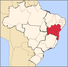
 Lençóis Location in Brazil | |
| Coordinates: 12°33′46″S 41°23′24″W / 12.56278°S 41.39000°WCoordinates: 12°33′46″S 41°23′24″W / 12.56278°S 41.39000°W | |
| Country |
|
| Region | Northeast Region |
| State | Bahia |
| Area | |
| • Total | 1,277 km2 (493 sq mi) |
| Population (2015) | |
| • Total | 11,445 |
| • Density | 9.0/km2 (23/sq mi) |
| Time zone | BRT (UTC-3) |
Lençóis is a municipality in the state of Bahia in Brazil. The population is 11,445 (2015 est.) in an area of 1277 km².[1] The town has a well-preserved colonial atmosphere and is the starting point for treks into Chapada Diamantina. The city is served by Horácio de Mattos Airport.

Cachoeira do Mosquito in Lençois - Bahia
References
External links
| Wikimedia Commons has media related to Lençóis. |
 Lençóis travel guide from Wikivoyage
This article is issued from Wikipedia - version of the 5/13/2016. The text is available under the Creative Commons Attribution/Share Alike but additional terms may apply for the media files.