Leonard Stanley
| Leonard Stanley | |
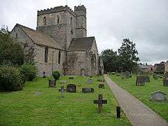 St Swithuns church |
|
 Leonard Stanley |
|
| Population | 1,466 [1] |
|---|---|
| OS grid reference | SO 80388 03653 |
| Shire county | Gloucestershire |
| Ceremonial county | Gloucestershire |
| Region | South West |
| Country | England |
| Sovereign state | United Kingdom |
| Post town | Stroud |
| Postcode district | GL10 |
| Dialling code | 01453 |
| Police | Gloucestershire |
| Fire | Gloucestershire |
| Ambulance | South Western |
| EU Parliament | South West England |
| UK Parliament | South Gloucestershire |
|
|
Coordinates: 51°43′48″N 2°17′09″W / 51.730005°N 2.285834°W
Leonard Stanley is a small village on the outskirts of Stonehouse in Gloucestershire. Approximately 2.5 miles from Stroud it is located east of the River Severn and North East of the Bristol channel. The surrounding land use around Leonard Stanley is primarily agricultural, however, Leonard Stanley does contain a small cluster of residential and urban usage.
A Gloucestershire village of 600 homes nestling beneath the Cotswold escarpment, overlooking the Severn Vale. Originally a Saxon village, Leonard Stanley became a busy weaving and agricultural centre, with shops and cottage industries, until the 1970s. In recent years the village profile has changed to that of a dormitory village, with families mostly commuting to the surrounding towns and cities. The community however still has a heart and this website celebrates the wealth of rural life that still exists, and the people who play a part in it. Leonard Stanley is situated seven miles from the city of Gloucester and thirty miles from Bristol. It is easily accessible by road with Junction 13 of the M5 motorway just three miles away. There are railway stations at Stroud, Stonehouse and Cam and international airports at Bristol, Cardiff & Birmingham.[2]
History
What once had been described as a market town, "Leonard Stanley with its fairs and its weekly market, for some time the only one in the hundred, was formerly a centre of trade; it was described as a market-town in 1650. It declined in importance after the 17th century, and the beginning of the decline was later associated with the fire of 1686." This later declined.[3]
The parish church of St Swithun dates from the 12th century and is a grade I listed building.[4] The nature reserve of Five Acre Grove lies close to the village and is designated a Key Wildlife Site (KWS).[5]
Text with reference to Leonard Stanley through Christian writing, "It was with difficulty we made our way through this most loving people, and returned amidst their prayers and blessings to Ebly. Here I expounded the second lesson for two hours, and received strength and faith to plead the promise of the Father. A good old Baptist pressed me to preach at Stanley, in my way to Bristol."[6]
Leonard Stanley is represented by the county councillor for Dursley division and the two district councillors for The Stanleys ward on Stroud District Council.
In 1870-72, John Marius Wilson's Imperial Gazetteer of England and Wales described Leonard Stanley.
LEONARD-STANLEY, or STANLEY-ST. LEONARDS, a village and a parish in Stroud district, Gloucester. The village stands 1 mile E by S of Frocester r. station, 1½ S by E of Stonehouse r. station, and 3½ SW by W of Stroud; was once a market-town; was nearly all destroyed by fire in 1686; and has a post office under Stonehouse, and a fair on 20 July. The parish contains also the hamlet of Downton, and includes the detached tract of Lorridge. Acres, 1,070. Real property, £4,188; of which £655 are in railways. [7]
Population

The population of Leonard Stanley has increased throughout the years, with a population as little as 590 in 1801. Leonard Stanley has seen a number of population 'booms' through the years; in 1811 the population dropped slightly to 538 but has continued to rise throughout each 10 year interval when the census' are held; peaking at 861 during 1851, then declining with pre-world war 1, dropping to 651 in 1911. After these troubled years, the population began to rise again, relatively slowly hitting 1,131 in 1961 and today standing at 1411.[8]
Leonard Stanley currently has a population of 1,446 with reference to the 2011 Census Key Statistics.[9]
Industry
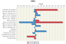
Even the first census of 1801 divided the population into those 'chiefly employed in agriculture', those 'chiefly employed in trade, manufacturers or handicraft', and others. From 1841 onwards, information was gathered on each person's occupation and this formed the basis for very detailed tables. The 1841 occupational tables, used here, listed over 3,000 different occupational titles. This was partly because no advance plans had been made for dealing with the enormous range of job titles people gave, but by 1881 the more organised classification used in the county level tables covered 414 categories. Unfortunately, because of the need to reorganise these statistics into different areas, for 1971 to 1991 we must work with data for over 10,000 wards, and only a very simple industrial classification is available for these. We therefore present long-run industrial change using just six broad sectors. This information is displayed with a table to the right of this page.[10]
Housing
The first census to report on how well people were housed was that of 1891, but the only statistics gathered were on the number of rooms and the number of people in each household. From 1951 onwards, more questions were asked about 'amenities', meaning specific facilities that households either possessed or had shared access to.[11]
Housing hadn't been an issue for Leonard Stanley since census' were first conducted; total housing flat lining from 1841 (earliest figures) 202 and a change between 1 - 2 houses from then until 1901 when there was a decline in housing, a drop to 193. The decline continued from here until 1951 where there was a rapid increase in housing, jumping to 229 and a massive jump to 365 in 1961.[12]
Governance
The village falls in 'The Stanleys' electoral ward. This ward runs east-west from King's Stanley to Frocester. The total ward population at the 2011 census was 3,960.[13]
Bibliography
- David Verey, Gloucestershire: the Cotswolds, The Buildings of England edited by Nikolaus Pevsner, 2nd ed. (1979) ISBN 0-14-071040-X, pp. 296–299
References
- ↑ 2011 UK census
- ↑ http://leonardstanley.org.uk/
- ↑ http://www.british-history.ac.uk/vch/glos/vol10/pp257-259#fnn59
- ↑ "Name: CHURCH OF ST SWITHIN List entry Number: 1171487". English Heritage. Retrieved 9 August 2014.
- ↑ Cotswold District Local Plan, Appendix 2, Key Wildlife Sites
- ↑ Charles Wesley, The Journal of the Rev. Charles Wesley (London: Hutchinson & Co., 1849)
- ↑ GB Historical GIS / University of Portsmouth, History of Leonard Stanley, in Stroud and Gloucestershire | Map and description, A Vision of Britain through Time.
- ↑ GB Historical GIS / University of Portsmouth, Leonard Stanley AP/CP through time | Population Statistics | Total Population, A Vision of Britain through Time.
- ↑ https://neighbourhood.statistics.gov.uk/dissemination/LeadTableView.do?a=7&b=11125558&c=leonard+stanley&d=16&e=62&g=6428066&i=1001x1003x1032x1004&m=0&r=1&s=1430317344585&enc=1&dsFamilyId=2473
- ↑ http://www.visionofbritain.org.uk/unit/10032570/theme/IND
- ↑ http://www.visionofbritain.org.uk/unit/10032570/theme/HOUS
- ↑ GB Historical GIS / University of Portsmouth, Leonard Stanley AP/CP through time | Housing Statistics | Total Houses, A Vision of Britain through Time.
- ↑ "The Stanleys ward 2011.Retrieved 31 March 2015".
External links
![]() Media related to Leonard Stanley at Wikimedia Commons
Media related to Leonard Stanley at Wikimedia Commons
![]() Media related to Leonard Stanley, Gloucestershire at Wikimedia Commons
Media related to Leonard Stanley, Gloucestershire at Wikimedia Commons
| Unitary authorities | |
|---|---|
| Boroughs or districts | |
| Major settlements |
|
| Rivers | |
| Topics | |