River Coln
For several similarly named rivers, see River Colne (disambiguation).
| River Coln | |
| River | |
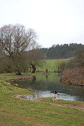
 River Coln south of Coln St Aldwyns, Gloucestershire | |
| Country | England |
|---|---|
| Counties | Gloucestershire |
| Towns | Fairford |
| Source | |
| - location | Brockhampton, Gloucestershire |
| Mouth | River Thames |
| - location | Lechlade, Gloucestershire |
| Discharge | for Fairford |
| - average | 2.06 m3/s (73 cu ft/s) |
| - max | 6.2 m3/s (219 cu ft/s) 21 February 1995 |
| - min | 0.51 m3/s (18 cu ft/s) 31 October 1990 |
| Discharge elsewhere (average) | |
| - Bibury | 1.33 m3/s (47 cu ft/s) |
| - Fossebridge | 0.47 m3/s (17 cu ft/s) |
The River Coln between Bibury and Coln St Aldwyn.
The River Coln is a river in Gloucestershire, England. It rises at Brockhampton to the east of Cheltenham, and flows in a south/south-easterly direction through the Cotswold Hills via Andoversford, Withington, Fossbridge, Bibury, Coln St Aldwyns, Quenington and Fairford. It joins the River Thames to the south-west of Lechlade, where it shares a confluence with the Thames and Severn Canal, by The Round House Footbridge.[1]
Extensive gravel pits that are now redundant, lying between Fairford and Lechlade, form the Eastern component of the Cotswold Water Park, which is fed and drained by the Coln.[2]
The river is host to many species of freshwater fish including brown trout and grayling.[1]
See also
References
- 1 2 http://www.ecn.ac.uk/sites/coln.html Environmental Change Network
- ↑ http://www.waterpark.org/ Cotswold Water Park
| Next confluence upstream | River Thames | Next confluence downstream |
| River Ray (south) | River Coln | River Leach (north) |
Coordinates: 51°41′N 1°42′W / 51.683°N 1.700°W
This article is issued from Wikipedia - version of the 11/30/2016. The text is available under the Creative Commons Attribution/Share Alike but additional terms may apply for the media files.