Lewiston, Utah
| Lewiston, Utah | |
|---|---|
| City | |
|
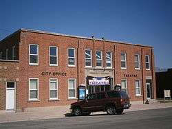
The Lewiston Community Building, built in 1935, is listed on the National Register of Historic Places. | |
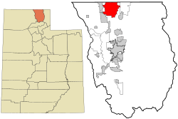 Location in Cache County and the state of Utah. | |
| Coordinates: 41°58′7″N 111°51′57″W / 41.96861°N 111.86583°WCoordinates: 41°58′7″N 111°51′57″W / 41.96861°N 111.86583°W | |
| Country | United States |
| State | Utah |
| County | Cache |
| Settled | 1870 |
| Named for | William H. Lewis |
| Area | |
| • Total | 25.7 sq mi (66.5 km2) |
| • Land | 25.6 sq mi (66.2 km2) |
| • Water | 0.1 sq mi (0.3 km2) |
| Elevation[1] | 4,508 ft (1,374 m) |
| Population (2012) | |
| • Total | 1,774 |
| • Density | 73.4/sq mi (28.3/km2) |
| Time zone | Mountain (MST) (UTC-7) |
| • Summer (DST) | MDT (UTC-6) |
| ZIP code | 84320 |
| Area code(s) | 435 |
| FIPS code | 49-44760[2] |
| GNIS feature ID | 1442573[1] |
Lewiston is a city in Cache County, Utah, United States. The population was 1,766 at the 2010 census. It is included in the Logan, Utah-Idaho (partial) Metropolitan Statistical Area.
Geography
According to the United States Census Bureau, the city has a total area of 25.7 square miles (66.5 km²), of which, 25.6 square miles (66.2 km²) of it is land and 0.1 square miles (0.3 km²) of it (0.43%) is water.
Climate
This climatic region is typified by large seasonal temperature differences, with warm to hot (and often humid) summers and cold (sometimes severely cold) winters. According to the Köppen Climate Classification system, Lewiston has a humid continental climate, abbreviated "Dfb" on climate maps.[3]
Demographics
| Historical population | |||
|---|---|---|---|
| Census | Pop. | %± | |
| 1880 | 525 | — | |
| 1890 | 754 | 43.6% | |
| 1900 | 995 | 32.0% | |
| 1910 | 989 | −0.6% | |
| 1920 | 1,646 | 66.4% | |
| 1930 | 1,783 | 8.3% | |
| 1940 | 1,804 | 1.2% | |
| 1950 | 1,533 | −15.0% | |
| 1960 | 1,336 | −12.9% | |
| 1970 | 1,244 | −6.9% | |
| 1980 | 1,438 | 15.6% | |
| 1990 | 1,532 | 6.5% | |
| 2000 | 1,877 | 22.5% | |
| 2010 | 1,766 | −5.9% | |
| Est. 2015 | 1,768 | [4] | 0.1% |
As of the census[2] of 2000, there were 1,877 people, 531 households, and 446 families residing in the city. The population density was 73.4 people per square mile (28.3/km²). There were 558 housing units at an average density of 21.8 per square mile (8.4/km²). The racial makeup of the city was 94.67% White, 0.11% African American, 0.05% Native American, 0.11% Asian, 3.68% from other races, and 1.39% from two or more races. Hispanic or Latino of any race were 6.29% of the population.
There were 531 households out of which 53.3% had children under the age of 18 living with them, 75.0% were married couples living together, 6.8% had a female householder with no husband present, and 16.0% were non-families. 14.3% of all households were made up of individuals and 7.3% had someone living alone who was 65 years of age or older. The average household size was 3.53 and the average family size was 3.94.
In the city the population was spread out with 39.4% under the age of 18, 12.3% from 18 to 24, 24.7% from 25 to 44, 14.5% from 45 to 64, and 9.1% who were 65 years of age or older. The median age was 24 years. For every 100 females there were 101.2 males. For every 100 females age 18 and over, there were 94.9 males.
The median income for a household in the city was $36,417, and the median income for a family was $41,705. Males had a median income of $28,750 versus $22,083 for females. The per capita income for the city was $12,385. About 8.7% of families and 10.2% of the population were below the poverty line, including 12.2% of those under age 18 and 9.0% of those age 65 or over.
See also
References
- 1 2 U.S. Geological Survey Geographic Names Information System: Lewiston
- 1 2 "American FactFinder". United States Census Bureau. Archived from the original on September 11, 2013. Retrieved 2008-01-31.
- ↑ Climate Summary for Lewiston, Utah
- ↑ "Annual Estimates of the Resident Population for Incorporated Places: April 1, 2010 to July 1, 2015". Retrieved July 2, 2016.
- ↑ "Census of Population and Housing". Census.gov. Archived from the original on May 11, 2015. Retrieved June 4, 2015.
External links
 |
|
|
|
|
| Cornish | |
Richmond | ||
| ||||
| | ||||
| Trenton | Amalga | Smithfield |
Municipalities and communities of Cache County, Utah, United States | ||
|---|---|---|
| Cities | 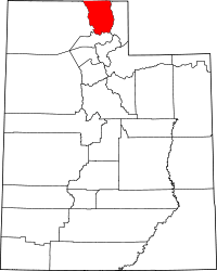 | |
| Towns | ||
| CDPs | ||
| Unincorporated community | ||
| Ghost town | ||