Liberty Hill, South Carolina
| Liberty Hill, South Carolina | |
|---|---|
| Unincorporated community | |
|
Liberty Hill Country Store | |
 Liberty Hill  Liberty Hill | |
| Coordinates: 34°28′42″N 80°48′06″W / 34.47833°N 80.80167°WCoordinates: 34°28′42″N 80°48′06″W / 34.47833°N 80.80167°W | |
| Country | United States |
| State | South Carolina |
| County | Kershaw |
| Elevation | 561 ft (171 m) |
| Time zone | Eastern (EST) (UTC-5) |
| • Summer (DST) | EDT (UTC-4) |
| ZIP code | 29074 |
| Area code(s) | 803 |
| GNIS feature ID | 1246358[1] |
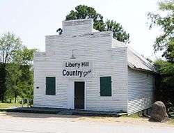
Liberty Hill is an unincorporated community in Kershaw County, South Carolina, United States.[1] The community is located at the junction of South Carolina Highway 97 and South Carolina Highway 522, 19.5 miles (31.4 km) northwest of Camden. Liberty Hill has a post office with ZIP code 29074, which opened on January 19, 1818.[2][3]
Parts of the community are included in the Liberty Hill Historic District, which is listed on the National Register of Historic Places.[4]
References
- 1 2 "Liberty Hill". Geographic Names Information System. United States Geological Survey.
- ↑ United States Postal Service. "USPS - Look Up a ZIP Code". Retrieved October 23, 2016.
- ↑ "Postmaster Finder - Post Offices by ZIP Code". United States Postal Service. Retrieved October 23, 2016.
- ↑ National Park Service (2010-07-09). "National Register Information System". National Register of Historic Places. National Park Service.
Municipalities and communities of Kershaw County, South Carolina, United States | ||
|---|---|---|
| City | 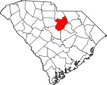 | |
| Towns | ||
| CDPs | ||
| Unincorporated communities | ||
This article is issued from Wikipedia - version of the 10/23/2016. The text is available under the Creative Commons Attribution/Share Alike but additional terms may apply for the media files.