Lily, Kentucky
| Lily | |
|---|---|
| Unincorporated community | |
 Lily  Lily Location within the state of Kentucky | |
| Coordinates: 37°1′28″N 84°4′31″W / 37.02444°N 84.07528°WCoordinates: 37°1′28″N 84°4′31″W / 37.02444°N 84.07528°W | |
| Country | United States |
| State | Kentucky |
| County | Laurel |
| Elevation | 1,119 ft (341 m) |
| Time zone | Eastern Time Zone (UTC-6) |
| • Summer (DST) | EST (UTC-5) |
| ZIP codes | 40740 |
| GNIS feature ID | 513422[1] |
Lily is an unincorporated community and coal town in Laurel County, Kentucky, United States. Their post office has been open since 1881.[2]
References
Municipalities and communities of Laurel County, Kentucky, United States | ||
|---|---|---|
| City | 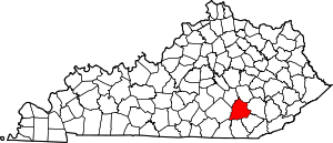 | |
| CDPs | ||
| Unincorporated communities | ||
| Footnotes | ‡This populated place also has portions in an adjacent county | |
This article is issued from Wikipedia - version of the 7/27/2016. The text is available under the Creative Commons Attribution/Share Alike but additional terms may apply for the media files.