List of Category A listed buildings in West Lothian

West Lothian shown within Scotland

This is a list of Category A listed buildings in West Lothian, Scotland.

In Scotland, the term listed building refers to a building or other structure officially designated as being of "special architectural or historic interest".[1] Category A structures are those considered to be "buildings of national or international importance, either architectural or historic, or fine little-altered examples of some particular period, style or building type."[2] Listing was begun by a provision in the Town and Country Planning (Scotland) Act 1947, and the current legislative basis for listing is the Planning (Listed Buildings and Conservation Areas) (Scotland) Act 1997.[3] The authority for listing rests with Historic Scotland, an executive agency of the Scottish Government, which inherited this role from the Scottish Development Department in 1991. Once listed, severe restrictions are imposed on the modifications allowed to a building's structure or its fittings. Listed building consent must be obtained from local authorities prior to any alteration to such a structure.[3] There are approximately 47,400 listed buildings in Scotland, of which around 8% (some 3,800) are Category A.[4]

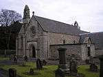
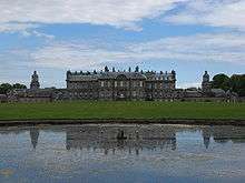
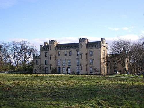
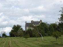
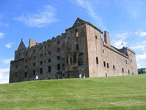
The council area of West Lothian covers 427 square kilometres (165 sq mi), and has a population of around 169,500. There are 42 Category A listed buildings within the area, ranging from Linlithgow Palace, a principal residence of the Kings of Scotland, to more modest farms and cottages such as Gowanbank or Woodcockdale. Historic churches include those at Abercorn, Mid Calder, Linlithgow, and Torphichen, the last being the only Scottish house of the Knights Hospitaller. Several small castles and tower houses merit Category A listing. More recent country houses include Hopetoun House, worked on successively by Sir William Bruce, William Adam and Robert Adam. A number of 19th century viaducts and aqueducts carry railways and canals across the River Avon and River Almond. In the historic royal burgh of Linlithgow, besides the palace and parish church, several town houses are listed at Category A. Few recent buildings in the area merit Category A listing, with nothing later than the church at Bangour Village Hospital, completed in 1930, being recognised as such.

Listed buildings

Name Location Date Listed Grid Ref. [note 1] Geo-coordinates Notes HB Number [note 2] Image
Abercorn Church Abercorn NT081790 55°59′44″N 3°28′27″W / 55.995579°N 3.474142°W / 55.995579; -3.474142 (Abercorn Church) 12th-century church with later alterations[5] 612

Upload another image
See more images

Hopetoun House 4 kilometres (2.5 mi) west of South Queensferry NT088790 55°59′45″N 3°27′47″W / 55.995713°N 3.462924°W / 55.995713; -3.462924 (Hopetoun House) Late 17th-century country house[6] 613

Upload another image

Hopetoun House estate buildings and steading Hopetoun House Estate NT0901678851 55°59′38″N 3°27′37″W / 55.993957°N 3.460196°W / 55.993957; -3.460196 (Hopetoun House estate buildings and steading) 18th-century estate buildings[7] 614
Midhope Castle Abercorn NT0728378685 55°59′32″N 3°29′16″W / 55.992134°N 3.487911°W / 55.992134; -3.487911 (Midhope Castle) 16th-century tower house[8] 630

Upload another image
See more images

House of the Binns 1.5 kilometres (0.93 mi) south of Blackness NT0508078567 55°59′26″N 3°31′23″W / 55.990643°N 3.523172°W / 55.990643; -3.523172 (House of the Binns) Country house dating to 1612–1630[9] 632

Upload another image
See more images

Duntarvie Castle 2km north of Winchburgh NT0905076477 55°58′22″N 3°27′32″W / 55.97264°N 3.458848°W / 55.97264; -3.458848 (Duntarvie Castle) Scots Renaissance house of circa 1590[10] 6422

Upload another image
See more images

Bangour Village Hospital, excluding villas 9, 23-29, 31, and boiler house 1 kilometre (0.62 mi) west of Dechmont NT0322171218 55°55′27″N 3°33′01″W / 55.924266°N 3.550318°W / 55.924266; -3.550318 (Bangour Village Hospital, excluding villas 9, 23-29, 31, and boiler house) Former hospital built 1898–1906, and church dating from the 1920s[11] 6588

Upload another image

Hatton House, south entrance gates 2 kilometres (1.2 mi) south of Ratho NT1279968444 55°54′04″N 3°23′46″W / 55.901183°N 3.396201°W / 55.901183; -3.396201 (Hatton House, south entrance gates) Gateway built 1692 as an entrance to the now-demolished Hatton House[12] 7355

Upload another image

Linhouse Viaduct 1.5 kilometres (0.93 mi) east of Murieston NT076647 55°52′01″N 3°28′38″W / 55.867043°N 3.477259°W / 55.867043; -3.477259 (Linhouse Viaduct) 1842 railway viaduct carrying the Edinburgh to Carstairs railway over the Linhouse Water[13] 7365

Upload another image

Almondell Bridge[note 3] 1 kilometre (0.62 mi) north of East Calder in Almondell and Calderwood Country Park NT0881668838 55°54′14″N 3°27′36″W / 55.903984°N 3.460012°W / 55.903984; -3.460012 (Almondell Bridge[note 4]) 1800 bridge over the River Almond[14][15] 7370

Upload another image

Almondell Bridge[note 6] 1 kilometre (0.62 mi) north of East Calder in Almondell and Calderwood Country Park NT0881668838 55°54′14″N 3°27′36″W / 55.903984°N 3.460012°W / 55.903984; -3.460012 (Almondell Bridge[note 7]) 1800 bridge over the River Almond[16][17] 14228

Upload another image

Almondell Aqueduct Almondell and Calderwood Country Park, East Calder NT0864068528 55°54′04″N 3°27′46″W / 55.901166°N 3.462721°W / 55.901166; -3.462721 (Almondell Aqueduct) 1820 aqueduct built to feed the Union Canal[18] 7371

Upload another image

Blackburn House Between Blackburn and Seafield NT000656 55°52′25″N 3°35′56″W / 55.873609°N 3.598983°W / 55.873609; -3.598983 (Blackburn House) 18th-century country house[19] 7419

Upload another image

Broxburn Viaduct 2.5 kilometres (1.6 mi) east of Broxburn NT1057872525 55°56′15″N 3°25′59″W / 55.937431°N 3.433062°W / 55.937431; -3.433062 (Broxburn Viaduct) Railway viaduct carrying the Edinburgh to Glasgow railway over the A89 road[20] 7427

Upload another image

Almond Valley Viaduct [note 9] 3 kilometres (1.9 mi) east of Broxburn NT1123772183 55°56′04″N 3°25′21″W / 55.934482°N 3.422403°W / 55.934482; -3.422403 (Almond Valley Viaduct [note 9]) 1842 railway viaduct carrying the Edinburgh to Glasgow railway over the River Almond[21] 7428

Upload another image

Almond Aqueduct [note 9] 3 kilometres (1.9 mi) south-east of Broxburn NT104706 55°55′14″N 3°26′04″W / 55.920566°N 3.434487°W / 55.920566; -3.434487 (Almond Aqueduct [note 9]) 1820 aqueduct carrying the Union Canal over the River Almond[22] 7430

Upload another image

Niddry Castle Near Winchburgh NT095743 55°57′13″N 3°27′00″W / 55.953631°N 3.450125°W / 55.953631; -3.450125 (Niddry Castle) Tower house of circa 1500[23] 7437

Upload another image
See more images

Avon Aqueduct [note 10] 3 kilometres (1.9 mi) south-west of Linlithgow NS967758 55°57′52″N 3°39′20″W / 55.96452°N 3.6556°W / 55.96452; -3.6556 (Avon Aqueduct [note 10]) 1822 aqueduct carrying the Union Canal over the River Almond[24] 7468

Upload another image

Kingscavil Cottages 3 kilometres (1.9 mi) east of Linlithgow NT030764 55°58′16″N 3°33′18″W / 55.971223°N 3.554936°W / 55.971223; -3.554936 (Kingscavil Cottages) 1873 cottages and former schoolhouse[25] 7482

Upload another image

Grange House 1.5 kilometres (0.93 mi) north of Linlithgow NT0002878768 55°59′29″N 3°36′15″W / 55.991421°N 3.604196°W / 55.991421; -3.604196 (Grange House) Early 20th-century country house[26] 12972
Ochiltree Castle 3.5 kilometres (2.2 mi) south-east of Linlithgow NT0326474760 55°57′22″N 3°33′03″W / 55.956087°N 3.550902°W / 55.956087; -3.550902 (Ochiltree Castle) Early 17th-century tower house[27] 12978

Upload another image

Preston House Preston Road, Linlithgow NS9957875849 55°57′54″N 3°36′37″W / 55.965111°N 3.610317°W / 55.965111; -3.610317 (Preston House) 19th-century baronial house by William Burn and David Bryce[28] 12983
Avon Viaduct [note 10] Linlithgow Bridge NS9816076951 55°58′29″N 3°38′00″W / 55.974709°N 3.63344°W / 55.974709; -3.63344 (Avon Viaduct [note 10]) 1842 viaduct carrying the Edinburgh to Glasgow railway over the River Avon[29] 12985

Upload another image

Woodcockdale, cottages and stables 2.5 kilometres (1.6 mi) south-west of Linlithgow NS9758775895 55°57′54″N 3°38′32″W / 55.965103°N 3.642215°W / 55.965103; -3.642215 (Woodcockdale, cottages and stables) Early 19th-century stables and cottages[30] 12989
Mid Calder Parish Church (St John's) Main Street, Mid Calder NT0737267323 55°53′24″N 3°28′57″W / 55.8901°N 3.48258°W / 55.8901; -3.48258 (Mid Calder Parish Church (St John's)) 16th-century Gothic church[31] 14144

Upload another image

Calder House Mid Calder NT0725967251 55°53′22″N 3°29′04″W / 55.889432°N 3.484362°W / 55.889432; -3.484362 (Calder House) 16th- or 17th-century mansion, incorporating walls of earlier fortalice[32] 14153

Upload another image

Calder House, east gateway West Calder Road, Mid Calder NT0742367187 55°53′20″N 3°28′54″W / 55.888889°N 3.481719°W / 55.888889; -3.481719 (Calder House, east gateway) Ornamental gateway of circa 1670[33] 14155

Upload another image

Linhouse 2 kilometres (1.2 mi) south of Murieston NT062629 55°51′02″N 3°29′56″W / 55.850606°N 3.498999°W / 55.850606; -3.498999 (Linhouse) 1589 country house[34] 14156
Houstoun House Uphall NT0526471334 55°55′33″N 3°31′04″W / 55.925715°N 3.517678°W / 55.925715; -3.517678 (Houstoun House) 17th-century house, now a hotel[35] 14243
Torphichen Preceptory and Torphichen Parish Church Torphichen NS9689472516 55°56′05″N 3°39′07″W / 55.934608°N 3.652019°W / 55.934608; -3.652019 (Torphichen Preceptory and Torphichen Parish Church) Gothic church of the 13th to 15th centuries, Scottish house of the Knights Hospitaller[36] 14532

Upload another image

Gowanbank 3 kilometres (1.9 mi) north-west of Armadale NS9157071261 55°55′20″N 3°44′12″W / 55.922165°N 3.736694°W / 55.922165; -3.736694 (Gowanbank) 19th-century farmhouse, steading and cottage by Sir James Gowans[37] 14557

Upload another image

Bathgate Academy Marjoribanks Street, Bathgate NS9794768697 55°54′02″N 3°38′01″W / 55.900534°N 3.633727°W / 55.900534; -3.633727 (Bathgate Academy) 19th-century Greek revival school[38] 22125

Upload another image

Linlithgow Burgh Halls The Cross, Linlithgow NT0021977204 55°58′39″N 3°36′02″W / 55.977414°N 3.600555°W / 55.977414; -3.600555 (Linlithgow Burgh Halls) 17th-century town house, including former jail and court house[39] 37362

Upload another image

Cross House 5 The Cross, Linlithgow NT0018277195 55°58′38″N 3°36′04″W / 55.977326°N 3.601145°W / 55.977326; -3.601145 (Cross House) 18th-century house, Category A listed for its interiors[40] 37363

Upload another image

St Michael's Well High Street, Linlithgow NT0041377119 55°58′36″N 3°35′51″W / 55.976691°N 3.597417°W / 55.976691; -3.597417 (St Michael's Well) Well dated 1720 with a statue of St Michael[41] 37383

Upload another image

West Port House 297-299 High Street, Linlithgow NS9965377027 55°58′33″N 3°36′34″W / 55.975706°N 3.609555°W / 55.975706; -3.609555 (West Port House) Laird's house, circa 1600 with later additions[42] 37430
Hamilton's Land 38-44 High Street, Linlithgow NT0039877139 55°58′37″N 3°35′52″W / 55.976868°N 3.597664°W / 55.976868; -3.597664 (Hamilton's Land) Early 17th-century tenement building, restored 1958[43] 37438
Hamilton's Land 46-48 High Street, Linlithgow NT0038977143 55°58′37″N 3°35′52″W / 55.976902°N 3.59781°W / 55.976902; -3.59781 (Hamilton's Land) Early 17th-century tenement building, restored 1958[44] 37439
Dovecot Learmonth Gardens, Linlithgow NT0034577008 55°58′32″N 3°35′54″W / 55.97568°N 3.598465°W / 55.97568; -3.598465 (Dovecot) 16th-century beehive dovecote[45] 37468

Upload another image

Linlithgow Palace Linlithgow Peel NT0019677325 55°58′43″N 3°36′03″W / 55.978496°N 3.600969°W / 55.978496; -3.600969 (Linlithgow Palace) Former royal palace built over 15th to 17th centuries, now in ruins[46] 37469

Upload another image
See more images

Linlithgow Palace Gateway Linlithgow Peel NT0019677279 55°58′41″N 3°36′03″W / 55.978083°N 3.600952°W / 55.978083; -3.600952 (Linlithgow Palace Gateway) Gateway to former royal palace, circa 1535[47] 37470

Upload another image

St Michael's Church Linlithgow Peel NT002772 55°58′40″N 3°36′00″W / 55.977834°N 3.600076°W / 55.977834; -3.600076 (St Michael's Church) 15th-century parish church[48] 37499

Upload another image

Notes

  1. Sometimes known as OSGB36, the grid reference (where provided) is based on the British national grid reference system used by the Ordnance Survey.
    "Guide to National Grid". Ordnance Survey. Retrieved 2007-12-12.
    "Get-a-map". Ordnance Survey. Retrieved 2007-12-17.
  2. The "HB Number" is a unique number assigned to each listed building by Historic Scotland.
  3. Almondell Bridge is listed twice
  4. Almondell Bridge is listed twice
  5. Almondell Bridge is listed twice
  6. Almondell Bridge is listed twice
  7. Almondell Bridge is listed twice
  8. Almondell Bridge is listed twice
  9. 1 2 3 4 5 6 Also in City of Edinburgh, as it crosses the River Almond which is the council boundary
  10. 1 2 3 4 5 6 Also in Falkirk, as it crosses the River Avon which is the council boundary

References

  1. Guide to the Protection of Scotland’s Listed Buildings (PDF). Historic Scotland. 2009. p. 4. ISBN 978-1-84917-013-0. Retrieved 2010-05-05.
  2. "What is Listing?". Historic Scotland. Retrieved 2010-05-05.
  3. 1 2 Scottish Historic Environment Policy (PDF). Historic Scotland. October 2008. pp. 24–25. ISBN 978-1-84917-002-4. Retrieved 2010-05-05.
  4. Guide to the Protection of Scotland’s Listed Buildings, p. 17.
  5. "Abercorn Church, Listed Building Report". Historic Scotland. Retrieved 2010-05-18.
  6. "Hopetoun House, Listed Building Report". Historic Scotland. Retrieved 2010-05-18.
  7. "Hopetoun House estate buildings and steading, Listed Building Report". Historic Scotland. Retrieved 2010-05-18.
  8. "Midhope Castle, Listed Building Report". Historic Scotland. Retrieved 2010-05-18.
  9. "House of the Binns, Listed Building Report". Historic Scotland. Retrieved 2010-05-18.
  10. "Duntarvie Castle, Listed Building Report". Historic Scotland. Retrieved 2010-05-18.
  11. "Bangour Village Hospital, Listed Building Report". Historic Scotland. Retrieved 2010-05-18.
  12. "Hatton House, south entrance gates, Listed Building Report". Historic Scotland. Retrieved 2010-05-18.
  13. "Linhouse Viaduct, Listed Building Report". Historic Scotland. Retrieved 2010-05-18.
  14. "Almondell Bridge, Listed Building Report". Historic Scotland. Retrieved 2010-05-18.
  15. "Almondell Bridge, Listed Building Report". Historic Scotland. Retrieved 2010-05-18.
  16. "Almondell Bridge, Listed Building Report". Historic Scotland. Retrieved 2010-05-18.
  17. "Almondell Bridge, Listed Building Report". Historic Scotland. Retrieved 2010-05-18.
  18. "Almondell Aqueduct, Listed Building Report". Historic Scotland. Retrieved 2010-05-18.
  19. "Blackburn House, Listed Building Report". Historic Scotland. Retrieved 2010-05-18.
  20. "Broxburn Viaduct, Listed Building Report". Historic Scotland. Retrieved 2010-05-18.
  21. "Almond Valley Viaduct, Listed Building Report". Historic Scotland. Retrieved 2010-05-18.
  22. "Almond Aqueduct, Listed Building Report". Historic Scotland. Retrieved 2010-05-18.
  23. "Niddry Castle, Listed Building Report". Historic Scotland. Retrieved 2010-05-18.
  24. "Avon Aqueduct, Listed Building Report". Historic Scotland. Retrieved 2010-05-18.
  25. "Kingscavil Cottages and Schoolhouse, Listed Building Report". Historic Scotland. Retrieved 2010-05-18.
  26. "Grange House, Listed Building Report". Historic Scotland. Retrieved 2010-05-18.
  27. "Ochiltree Castle, Listed Building Report". Historic Scotland. Retrieved 2010-05-18.
  28. "Preston House, Listed Building Report". Historic Scotland. Retrieved 2010-05-18.
  29. "Avon Viaduct, Listed Building Report". Historic Scotland. Retrieved 2010-05-18.
  30. "Woodcockdale, Listed Building Report". Historic Scotland. Retrieved 2010-05-18.
  31. "Mid Calder Parish Church (St John's), Listed Building Report". Historic Scotland. Retrieved 2010-05-18.
  32. "Calder House, Listed Building Report". Historic Scotland. Retrieved 2010-05-18.
  33. "Calder House, east gateway, Listed Building Report". Historic Scotland. Retrieved 2010-05-18.
  34. "Linhouse, Listed Building Report". Historic Scotland. Retrieved 2010-05-18.
  35. "Houstoun House, Listed Building Report". Historic Scotland. Retrieved 2010-05-18.
  36. "Torphichen Preceptory and Parish Church, Listed Building Report". Historic Scotland. Retrieved 2010-05-18.
  37. "Gowanbank, Listed Building Report". Historic Scotland. Retrieved 2010-05-18.
  38. "Bathgate Academy, Listed Building Report". Historic Scotland. Retrieved 2010-05-18.
  39. "Burgh Halls (Former Town House And Old Country Hall), Listed Building Report". Historic Scotland. Retrieved 2010-05-18.
  40. "Cross House, Listed Building Report". Historic Scotland. Retrieved 2010-05-18.
  41. "St Michael's Well, Listed Building Report". Historic Scotland. Retrieved 2010-05-18.
  42. "West Port House, Listed Building Report". Historic Scotland. Retrieved 2010-05-18.
  43. "38-44 High Street, Hamilton's Land, Listed Building Report". Historic Scotland. Retrieved 2010-05-18.
  44. "46-48 High Street, Hamilton's Land, Listed Building Report". Historic Scotland. Retrieved 2010-05-18.
  45. "Dovecot, Learmonth Gardens, Listed Building Report". Historic Scotland. Retrieved 2010-05-18.
  46. "Linlithgow Palace, Listed Building Report". Historic Scotland. Retrieved 2010-05-18.
  47. "Linlithgow Palace, Gate-house, Listed Building Report". Historic Scotland. Retrieved 2010-05-18.
  48. "St Michael's Parish Church, Listed Building Report". Historic Scotland. Retrieved 2010-05-18.

Media related to Category A listed buildings in West Lothian at Wikimedia Commons

This article is issued from Wikipedia - version of the 6/28/2016. The text is available under the Creative Commons Attribution/Share Alike but additional terms may apply for the media files.