| Name |
Location |
Date Listed |
Grid Ref. [note 1] |
Geo-coordinates |
Notes |
HB Number [note 2] |
Image |
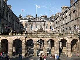
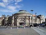
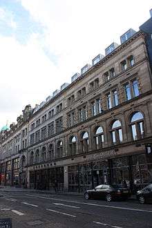
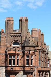
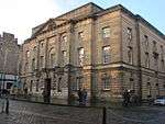
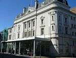
| Edinburgh City Chambers |
253 High Street |
14 December 1970 |
|
55°57′01″N 3°11′25″W / 55.950286°N 3.190357°W / 55.950286; -3.190357 (Edinburgh City Chambers) |
|
17597 |
 Upload another image
See more images
|
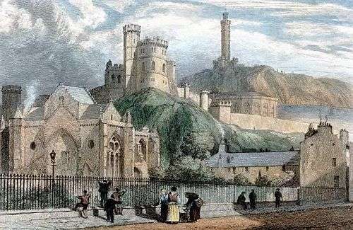
| Trinity College Church Apse |
Chalmer's Close (between High Street and Jeffrey Street) |
14 December 1970 |
|
55°57′04″N 3°11′08″W / 55.950989°N 3.185462°W / 55.950989; -3.185462 (Trinity College Church Apse) |
|
25747 |
 Upload another image
See more images
|
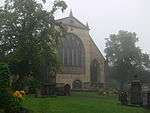
| Kirk of the Canongate |
|
14 December 1970 |
|
55°57′06″N 3°10′46″W / 55.95172°N 3.179559°W / 55.95172; -3.179559 (Kirk of the Canongate) |
|
26823 |
 Upload another image
See more images
|
| Greyfriars Kirk |
Greyfriars Place |
14 December 1970 |
|
55°56′48″N 3°11′32″W / 55.946593°N 3.192213°W / 55.946593; -3.192213 (Greyfriars Kirk) |
|
27018 |
 Upload another image
See more images
|
| Greyfriars Kirkyard |
Greyfriars Place |
14 December 1970 |
|
55°56′45″N 3°11′32″W / 55.945739°N 3.192267°W / 55.945739; -3.192267 (Greyfriars Kirkyard) |
|
27029 |
 Upload another image
See more images
|
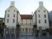
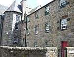
| Magdalene Chapel |
41 Cowgate |
14 December 1970 |
|
55°56′53″N 3°11′33″W / 55.947938°N 3.192511°W / 55.947938; -3.192511 (Magdalene Chapel) |
|
27110 |
 Upload another image
|
| St Giles' Cathedral |
High Street |
14 December 1970 |
|
55°56′58″N 3°11′27″W / 55.94958°N 3.190912°W / 55.94958; -3.190912 (St Giles' Cathedral) |
|
27381 |
 Upload another image
See more images
|
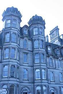
| The Hub Festival Centre |
348–350 Castlehill |
14 December 1970 |
|
55°56′56″N 3°11′43″W / 55.948865°N 3.19515°W / 55.948865; -3.19515 (The Hub Festival Centre) |
|
27542 |
 Upload another image
See more images
|
| General Assembly Hall of the Church of Scotland |
The Mound |
14 December 1970 |
|
55°56′58″N 3°11′43″W / 55.94944°N 3.195199°W / 55.94944; -3.195199 (General Assembly Hall of the Church of Scotland) |
|
27689 |
.jpg) Upload another image
|
| Tron Kirk |
High Street |
14 December 1970 |
|
55°57′00″N 3°11′16″W / 55.949969°N 3.187833°W / 55.949969; -3.187833 (Tron Kirk) |
|
27552 |
 Upload another image
See more images
|
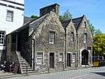
| Canongate Tolbooth |
163 Canongate |
14 December 1970 |
|
55°57′06″N 3°10′48″W / 55.951535°N 3.18005°W / 55.951535; -3.18005 (Canongate Tolbooth) |
Now used by The People's Story Museum |
27582 |
 Upload another image
See more images
|
| The Supreme Courts of Scotland |
Parliament Square |
14 December 1970 |
|
55°56′56″N 3°11′25″W / 55.948939°N 3.190316°W / 55.948939; -3.190316 (The Supreme Courts of Scotland) |
|
27699 |
 Upload another image
|
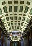
| Parliament Hall |
Parliament Square |
14 December 1970 |
|
55°56′56″N 3°11′27″W / 55.948843°N 3.190969°W / 55.948843; -3.190969 (Parliament Hall) |
|
27704 |
 Upload another image
|
| Signet Library |
Parliament Square |
14 December 1970 |
|
55°56′57″N 3°11′30″W / 55.949143°N 3.191539°W / 55.949143; -3.191539 (Signet Library) |
|
27709 |
 Upload another image
See more images
|
| District Courts (Formerly Police Chambers) |
1 and 1A Parliament Square |
14 December 1970 |
|
55°56′58″N 3°11′23″W / 55.949555°N 3.189726°W / 55.949555; -3.189726 (District Courts (Formerly Police Chambers)) |
|
27714 |

|
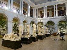
| National Museum of Scotland |
44 Chambers Street |
14 December 1970 |
|
55°56′49″N 3°11′22″W / 55.946899°N 3.18934°W / 55.946899; -3.18934 (National Museum of Scotland) |
|
27748 |
 Upload another image
See more images
|
| St Andrew's House |
Regent Road |
14 December 1970 |
|
55°57′13″N 3°11′02″W / 55.953519°N 3.184002°W / 55.953519; -3.184002 (St Andrew's House) |
|
27756 |
 Upload another image
See more images
|
| St Cecilia's Hall |
Cowgate |
14 December 1970 |
|
55°56′56″N 3°11′11″W / 55.948886°N 3.186487°W / 55.948886; -3.186487 (St Cecilia's Hall) |
|
27760 |
 Upload another image
|
| Usher Hall |
Cambridge Street |
14 December 1970 |
|
55°56′51″N 3°12′18″W / 55.947448°N 3.205066°W / 55.947448; -3.205066 (Usher Hall) |
|
27780 |
 Upload another image
See more images
|
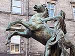
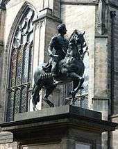
| Alexander and Bucephalus Statue |
High Street, City Chambers Courtyard |
14 December 1970 |
|
55°57′00″N 3°11′25″W / 55.950098°N 3.190271°W / 55.950098; -3.190271 (Alexander and Bucephalus Statue) |
|
27855 |
 Upload another image
See more images
|
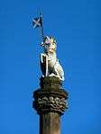
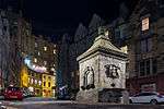
| Mercat Cross |
High Street |
14 December 1970 |
|
55°56′59″N 3°11′25″W / 55.94965°N 3.190209°W / 55.94965; -3.190209 (Mercat Cross) |
|
27792 |
 Upload another image
See more images
|
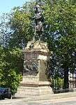
| Memorial to Walter Francis, 5th Duke of Buccleuch and 7th Duke of Queensberry |
High Street |
14 December 1970 |
|
55°56′58″N 3°11′30″W / 55.949491°N 3.191742°W / 55.949491; -3.191742 (Memorial to Walter Francis, 5th Duke of Buccleuch and 7th Duke of Queensberry) |
|
27844 |
 Upload another image
|
| Bowfoot Well |
West Bow |
21 April 1969 |
|
55°56′53″N 3°11′40″W / 55.947991°N 3.194498°W / 55.947991; -3.194498 (Bowfoot Well) |
|
27893 |
 Upload another image
|
| Greyfriars Bobby Fountain |
George IV Bridge |
29 April 1977 |
|
55°56′49″N 3°11′29″W / 55.946934°N 3.191327°W / 55.946934; -3.191327 (Greyfriars Bobby Fountain) |
|
27899 |
 Upload another image
See more images
|
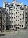
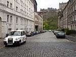
| George IV Bridge |
|
14 December 1970 |
|
55°56′54″N 3°11′31″W / 55.948195°N 3.191942°W / 55.948195; -3.191942 (George IV Bridge) |
|
27942 |
 Upload another image
See more images
|
| Netherbow Wellhead |
High Street |
14 December 1970 |
|
55°57′02″N 3°11′07″W / 55.950542°N 3.185256°W / 55.950542; -3.185256 (Netherbow Wellhead) |
|
27901 |
|
| Edinburgh College of Art |
Lauriston Place |
14 December 1970 |
|
55°56′45″N 3°11′59″W / 55.945829°N 3.199636°W / 55.945829; -3.199636 (Edinburgh College of Art) |
|
27974 |
 Upload another image
See more images
|
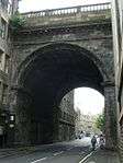
| King's Bridge |
King's Stables Road |
14 December 1970 |
|
55°56′51″N 3°12′06″W / 55.94749°N 3.201609°W / 55.94749; -3.201609 (King's Bridge) |
|
27943 |
.jpg) Upload another image
|
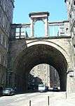
| Regent Bridge |
Over Calton Road |
19 April 1966 |
|
55°57′13″N 3°11′14″W / 55.953668°N 3.187226°W / 55.953668; -3.187226 (Regent Bridge) |
|
27945 |
 Upload another image
See more images
|
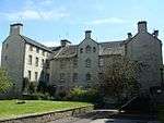
| George Heriot's School, Main Building |
Lauriston Place |
25 July 1966 |
|
55°56′45″N 3°11′41″W / 55.945913°N 3.194674°W / 55.945913; -3.194674 (George Heriot's School, Main Building) |
|
27980 |
 Upload another image
|
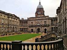
| Old College, University of Edinburgh |
South Bridge |
14 December 1970 |
|
55°56′51″N 3°11′12″W / 55.947555°N 3.186638°W / 55.947555; -3.186638 (Old College, University of Edinburgh) |
|
27989 |
 Upload another image
See more images
|
| Bastion of Flodden Wall, and Telfer Wall (Section) |
The Vennel |
14 December 1970 |
|
55°56′46″N 3°11′49″W / 55.946214°N 3.196989°W / 55.946214; -3.196989 (Bastion of Flodden Wall, and Telfer Wall (Section)) |
|
28006 |
 Upload another image
|
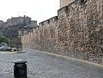
| Batteries, including Argyle, Dury's, Forewall, Half-Moon, and Western Defences |
Edinburgh Castle |
14 December 1970 |
|
55°56′54″N 3°11′56″W / 55.948307°N 3.198944°W / 55.948307; -3.198944 (Batteries, including Argyle, Dury's, Forewall, Half-Moon, and Western Defences) |
|
28010 |
 Upload another image
|
| Esplanade |
Edinburgh Castle |
14 December 1970 |
|
55°56′55″N 3°11′51″W / 55.948726°N 3.197435°W / 55.948726; -3.197435 (Esplanade) |
|
28011 |
 Upload another image
See more images
|
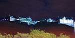
| Palace of Holyroodhouse |
Holyroodhouse |
14 December 1970 |
|
55°57′10″N 3°10′20″W / 55.952715°N 3.172286°W / 55.952715; -3.172286 (Palace of Holyroodhouse) |
|
28022 |
 Upload another image
See more images
|
| Fountain in Forecourt |
Palace of Holyroodhouse |
14 December 1970 |
|
55°57′09″N 3°10′23″W / 55.952601°N 3.172924°W / 55.952601; -3.172924 (Fountain in Forecourt) |
|
28024 |
 Upload another image
|
| Queen Mary's Bath House |
Holyroodhouse, Abbeyhill |
14 December 1970 |
|
55°57′13″N 3°10′27″W / 55.953505°N 3.174216°W / 55.953505; -3.174216 (Queen Mary's Bath House) |
|
28028 |
 Upload another image
|
| 28 and 30 Croft-An-Righ (Croft and Righ House) |
Holyroodhouse |
14 December 1970 |
|
55°57′15″N 3°10′17″W / 55.954135°N 3.17132°W / 55.954135; -3.17132 (28 and 30 Croft-An-Righ (Croft and Righ House)) |
|
28029 |
|
| Sundial, North Garden |
Holyroodhouse |
14 December 1970 |
|
55°57′13″N 3°10′23″W / 55.95348°N 3.173126°W / 55.95348; -3.173126 (Sundial, North Garden) |
|
28030 |
|
| Double Tree Hotel (Before 2014 this was the Point Hotel) |
28–36 Bread Street |
1 June 1979 |
|
55°56′44″N 3°12′13″W / 55.945619°N 3.203712°W / 55.945619; -3.203712 (Double Tree Hotel (Before 2014 this was the Point Hotel)) |
|
28347 |
 Upload another image
|
| 36–42 Candlemaker Row |
|
14 December 1970 |
|
55°56′49″N 3°11′30″W / 55.946931°N 3.191631°W / 55.946931; -3.191631 (36–42 Candlemaker Row) |
Including Candlemakers' Hall |
28416 |
 Upload another image
|
| Russell House |
3 Canongate |
14 December 1970 |
|
55°57′10″N 3°10′30″W / 55.952761°N 3.174994°W / 55.952761; -3.174994 (Russell House) |
|
28426 |
|
| Reid's Court, Canongate Manse |
95 Canongate |
14 December 1970 |
|
55°57′08″N 3°10′39″W / 55.952323°N 3.177608°W / 55.952323; -3.177608 (Reid's Court, Canongate Manse) |
|
28429 |
|
| Panmure House (Little Lochend Close) |
115 Canongate |
14 December 1970 |
|
55°57′08″N 3°10′42″W / 55.952234°N 3.178454°W / 55.952234; -3.178454 (Panmure House (Little Lochend Close)) |
|
28431 |
|
| 167 and 169 Canongate |
|
14 December 1970 |
|
55°57′05″N 3°10′49″W / 55.951525°N 3.180194°W / 55.951525; -3.180194 (167 and 169 Canongate) |
|
28433 |
|
| Queensberry House |
64 Canongate |
14 December 1970 |
|
55°57′07″N 3°10′34″W / 55.952033°N 3.175981°W / 55.952033; -3.175981 (Queensberry House) |
|
28440 |
 Upload another image
|
| Huntly House |
142 and 146 Canongate |
14 December 1970 |
|
55°57′05″N 3°10′46″W / 55.951289°N 3.179562°W / 55.951289; -3.179562 (Huntly House) |
Occupied by the Museum of Edinburgh |
28445 |
 Upload another image
|
| Acheson House |
140 Canongate |
14 October 1970 |
|
55°57′04″N 3°10′45″W / 55.951212°N 3.179127°W / 55.951212; -3.179127 (Acheson House) |
|
28446 |
 Upload another image
See more images
|
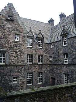
| Moray House |
174 Canongate |
14 December 1970 |
|
55°57′04″N 3°10′50″W / 55.951019°N 3.180515°W / 55.951019; -3.180515 (Moray House) |
|
28449 |
 Upload another image
See more images
|
| 3, 4, 5, 6 and 6B Chessel's Court (S Block) including St Saviour's Child Garden |
Canongate |
14 December 1970 |
|
55°57′01″N 3°10′59″W / 55.950374°N 3.183089°W / 55.950374; -3.183089 (3, 4, 5, 6 and 6B Chessel's Court (S Block) including St Saviour's Child Garden) |
|
28454 |
|
| Outlook Tower |
549 Castlehill |
14 December 1970 |
|
55°57′00″N 3°11′38″W / 55.950091°N 3.193762°W / 55.950091; -3.193762 (Outlook Tower) |
|
28488 |
 Upload another image
|
| Boswell's Court |
352 Castlehill |
14 December 1970 |
|
55°56′56″N 3°11′44″W / 55.948788°N 3.195644°W / 55.948788; -3.195644 (Boswell's Court) |
|
28489 |
|
| Cannonball House |
356 Castlehill and 2 Castle Wynd North |
14 December 1970 |
|
55°56′56″N 3°11′46″W / 55.948765°N 3.196203°W / 55.948765; -3.196203 (Cannonball House) |
|
28491 |
|
| 139 Cowgate, Former Tailor's Hall |
|
14 December 1970 |
|
55°56′53″N 3°11′24″W / 55.948134°N 3.189955°W / 55.948134; -3.189955 (139 Cowgate, Former Tailor's Hall) |
|
28595 |
|
| Library for Solicitors in the Supreme Courts of Scotland |
94–114 Cowgate |
12 December 1974 |
|
55°56′55″N 3°11′26″W / 55.948533°N 3.190511°W / 55.948533; -3.190511 (Library for Solicitors in the Supreme Courts of Scotland) |
|
28600 |
 Upload another image
|
| 98 Grassmarket |
|
21 April 1969 |
|
55°56′53″N 3°11′41″W / 55.948033°N 3.194772°W / 55.948033; -3.194772 (98 Grassmarket) |
|
28943 |
.jpg) Upload another image
|
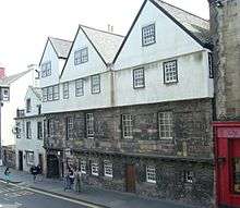
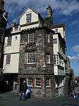
| John Knox House |
45 High Street |
14 December 1970 |
|
55°57′02″N 3°11′06″W / 55.950669°N 3.1851°W / 55.950669; -3.1851 (John Knox House) |
|
29033 |
 Upload another image
See more images
|
| Moubray House |
51–55 High Street |
14 December 1970 |
|
55°57′02″N 3°11′07″W / 55.950677°N 3.185228°W / 55.950677; -3.185228 (Moubray House) |
|
29034 |
 Upload another image
|
| 197–207 High Street including 1–14 Fleshmarket Close |
|
14 December 1970 |
|
55°57′01″N 3°11′19″W / 55.950186°N 3.188624°W / 55.950186; -3.188624 (197–207 High Street including 1–14 Fleshmarket Close) |
|
29045 |
 Upload another image
|
| 209–213 High Street including 1–6 Jackson's Close |
|
14 December 1970 |
|
55°57′01″N 3°11′20″W / 55.950167°N 3.188752°W / 55.950167; -3.188752 (209–213 High Street including 1–6 Jackson's Close) |
|
29046 |
Upload another image
|
| 215–219 High Street |
|
14 December 1970 |
|
55°57′01″N 3°11′20″W / 55.950372°N 3.18895°W / 55.950372; -3.18895 (215–219 High Street) |
|
29047 |
Upload another image
|
| 221–231 High Street |
|
14 December 1970 |
|
55°57′00″N 3°11′21″W / 55.950136°N 3.189135°W / 55.950136; -3.189135 (221–231 High Street) |
|
29048 |
|
| 233–243 High Street |
|
14 December 1970 |
|
55°57′00″N 3°11′22″W / 55.950116°N 3.189327°W / 55.950116; -3.189327 (233–243 High Street) |
|
29049 |
|
| 343–363 High Street and 2–8 Advocate's Close |
|
14 December 1970 |
|
55°56′59″N 3°11′29″W / 55.949845°N 3.191368°W / 55.949845; -3.191368 (343–363 High Street and 2–8 Advocate's Close) |
|
29050 |
 Upload another image
|
| 367–381 High Street |
|
14 December 1970 |
|
55°56′59″N 3°11′30″W / 55.949778°N 3.191767°W / 55.949778; -3.191767 (367–381 High Street) |
|
29052 |
 Upload another image
|
| Adam Bothwell's House |
High Street, 3 Advocate's Close |
14 December 1970 |
|
55°57′00″N 3°11′30″W / 55.949951°N 3.19158°W / 55.949951; -3.19158 (Adam Bothwell's House) |
|
29053 |
|
| Lord Reid Building |
High Street, New Assembly Close |
14 December 1970 |
|
55°56′58″N 3°11′19″W / 55.949531°N 3.188492°W / 55.949531; -3.188492 (Lord Reid Building) |
|
29069 |
|
| 435 Lawnmarket, including Deacon Brodie's Tavern |
|
14 December 1970 |
|
55°56′59″N 3°11′35″W / 55.949649°N 3.193028°W / 55.949649; -3.193028 (435 Lawnmarket, including Deacon Brodie's Tavern) |
|
29227 |
 Upload another image
|
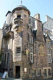
| Lady Stair's House |
Lady Stair's Close, Lawnmarket |
14 December 1970 |
|
55°56′59″N 3°11′37″W / 55.949669°N 3.193749°W / 55.949669; -3.193749 (Lady Stair's House) |
|
29231 |
 Upload another image
See more images
|
| Gladstone's Land |
481 and 483 Lawnmarket |
14 December 1970 |
|
55°56′58″N 3°11′38″W / 55.949481°N 3.193759°W / 55.949481; -3.193759 (Gladstone's Land) |
|
29233 |
 Upload another image
See more images
|
| 491–495 Lawnmarket |
|
14 December 1970 |
|
55°56′58″N 3°11′38″W / 55.949462°N 3.193823°W / 55.949462; -3.193823 (491–495 Lawnmarket) |
|
29234 |
|
| Milne's Court, including Edward Salveson Hall and Philip Henman Hall |
513–521 Lawnmarket |
14 December 1970 |
|
55°56′57″N 3°11′40″W / 55.949295°N 3.194362°W / 55.949295; -3.194362 (Milne's Court, including Edward Salveson Hall and Philip Henman Hall) |
|
29237 |
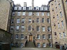 Upload another image
See more images
|
| 302–310 Lawnmarket, including Buchanan's Close and Brodie's Close |
|
14 December 1970 |
|
55°56′57″N 3°11′35″W / 55.949227°N 3.193047°W / 55.949227; -3.193047 (302–310 Lawnmarket, including Buchanan's Close and Brodie's Close) |
|
29239 |
|
| 312–320 Lawnmarket, including Fisher's Close |
|
14 December 1970 |
|
55°56′57″N 3°11′37″W / 55.949187°N 3.193478°W / 55.949187; -3.193478 (312–320 Lawnmarket, including Fisher's Close) |
|
29240 |
|
| 322–328 Lawnmarket, including Riddles Court, Riddles Close and 5 and 6 Victoria Terrace |
|
14 December 1970 |
|
55°56′56″N 3°11′37″W / 55.948988°N 3.193536°W / 55.948988; -3.193536 (322–328 Lawnmarket, including Riddles Court, Riddles Close and 5 and 6 Victoria Terrace) |
|
29242 |
|
| 89 West Bow |
|
21 April 1969 |
|
55°56′54″N 3°11′41″W / 55.948339°N 3.194765°W / 55.948339; -3.194765 (89 West Bow) |
|
29903 |
 Upload another image
|
| 91 and 93 West Bow, including Crocket's Land |
|
21 April 1969 |
|
55°56′54″N 3°11′41″W / 55.948285°N 3.194747°W / 55.948285; -3.194747 (91 and 93 West Bow, including Crocket's Land) |
|
29904 |
Upload another image
|
| 95–99 West Bow |
|
21 April 1969 |
|
55°56′54″N 3°11′41″W / 55.94824°N 3.194762°W / 55.94824; -3.194762 (95–99 West Bow) |
|
29905 |
Upload another image
|
| 101 and 103 West Bow |
|
21 April 1969 |
|
55°56′53″N 3°11′41″W / 55.948086°N 3.194853°W / 55.948086; -3.194853 (101 and 103 West Bow) |
|
29906 |
Upload another image
|
| Black Watch (South African War) Memorial |
Bank Street (Corner Market Street) |
12 December 1974 |
|
55°57′00″N 3°11′40″W / 55.950129°N 3.194548°W / 55.950129; -3.194548 (Black Watch (South African War) Memorial) |
|
30034 |
 Upload another image
See more images
|
| North Bridge |
|
12 December 1974 |
|
55°57′06″N 3°11′17″W / 55.951727°N 3.188143°W / 55.951727; -3.188143 (North Bridge) |
|
30035 |
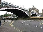 Upload another image
See more images
|
| Lauriston Place Fire Station |
Lauriston Place |
13 August 1987 |
|
55°56′44″N 3°11′59″W / 55.94547°N 3.199656°W / 55.94547; -3.199656 (Lauriston Place Fire Station) |
|
30123 |
 Upload another image
|
| 20–52 North Bridge, 175 and 177 High Street and 65–71 Cockburn Street |
|
12 December 1974 |
|
55°57′03″N 3°11′18″W / 55.950925°N 3.188439°W / 55.950925; -3.188439 (20–52 North Bridge, 175 and 177 High Street and 65–71 Cockburn Street) |
Including Scotsman Hotel, Scotsman Steps, Arcade, and Royal Mile Mansions |
30143 |
 Upload another image
|
| 26–28 Castle Terrace |
|
14 December 1970 |
|
55°56′50″N 3°12′11″W / 55.947181°N 3.202944°W / 55.947181; -3.202944 (26–28 Castle Terrace) |
|
47853 |
 Upload another image
|
| 29 Castle Terrace |
|
14 December 1970 |
|
55°56′50″N 3°12′09″W / 55.947094°N 3.202621°W / 55.947094; -3.202621 (29 Castle Terrace) |
|
47854 |
|
| 30, 31 and 32 Castle Terrace |
|
14 December 1970 |
|
55°56′49″N 3°12′09″W / 55.947077°N 3.20254°W / 55.947077; -3.20254 (30, 31 and 32 Castle Terrace) |
|
47855 |
|
| 33, 34 and 35 Castle Terrace |
|
14 December 1970 |
|
55°56′49″N 3°12′10″W / 55.946941°N 3.202664°W / 55.946941; -3.202664 (33, 34 and 35 Castle Terrace) |
|
47856 |
|
| 36 Castle Terrace |
|
14 December 1970 |
|
55°56′48″N 3°12′10″W / 55.946787°N 3.202772°W / 55.946787; -3.202772 (36 Castle Terrace) |
|
47857 |
|
| Victoria Terrace, with steps leading from Victoria Street to Upper Bow |
|
29 March 2001 |
|
55°56′55″N 3°11′39″W / 55.948669°N 3.194071°W / 55.948669; -3.194071 (Victoria Terrace, with steps leading from Victoria Street to Upper Bow) |
|
47901 |
 Upload another image
|
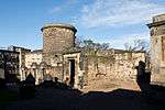
| Edinburgh Castle, Foog's Gate |
|
14 December 1970 |
|
55°56′54″N 3°12′01″W / 55.948445°N 3.200405°W / 55.948445; -3.200405 (Edinburgh Castle, Foog's Gate) |
|
48217 |
 Upload another image
|
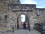
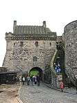
| Edinburgh Castle, Gatehouse |
|
14 December 1970 |
|
55°56′55″N 3°11′55″W / 55.948588°N 3.198696°W / 55.948588; -3.198696 (Edinburgh Castle, Gatehouse) |
|
48218 |
 Upload another image
|
| Edinburgh Castle, Governor's House |
|
14 December 1970 |
|
55°56′55″N 3°12′04″W / 55.948699°N 3.201166°W / 55.948699; -3.201166 (Edinburgh Castle, Governor's House) |
|
48219 |
 Upload another image
|
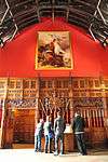
| Edinburgh Castle, Great Hall |
|
14 December 1970 |
|
55°56′53″N 3°12′00″W / 55.947975°N 3.199862°W / 55.947975; -3.199862 (Edinburgh Castle, Great Hall) |
|
48220 |
 Upload another image
|
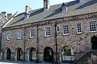
| Edinburgh Castle, New Barracks |
|
14 December 1970 |
|
55°56′54″N 3°12′05″W / 55.948462°N 3.20143°W / 55.948462; -3.20143 (Edinburgh Castle, New Barracks) |
|
48224 |
 Upload another image
|
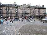
| Edinburgh Castle, Palace Block |
|
14 December 1970 |
|
55°56′53″N 3°11′58″W / 55.948186°N 3.199372°W / 55.948186; -3.199372 (Edinburgh Castle, Palace Block) |
|
48226 |
 Upload another image
|
| Edinburgh Castle, Portcullis Gate and Argyle Tower |
|
14 December 1970 |
|
55°56′56″N 3°11′59″W / 55.948884°N 3.199698°W / 55.948884; -3.199698 (Edinburgh Castle, Portcullis Gate and Argyle Tower) |
|
48227 |
 Upload another image
|
| Edinburgh Castle, St Margaret's Chapel |
|
14 December 1970 |
|
55°56′55″N 3°12′00″W / 55.948691°N 3.200092°W / 55.948691; -3.200092 (Edinburgh Castle, St Margaret's Chapel) |
|
48228 |
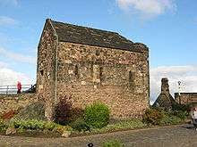 Upload another image
See more images
|
| Edinburgh Castle, Scottish National War Memorial |
|
14 December 1970 |
|
55°56′54″N 3°11′59″W / 55.948451°N 3.199797°W / 55.948451; -3.199797 (Edinburgh Castle, Scottish National War Memorial) |
|
48229 |
 Upload another image
|
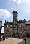
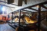
| Edinburgh Castle, United Services Museum |
|
14 December 1970 |
|
55°56′54″N 3°12′01″W / 55.948223°N 3.20019°W / 55.948223; -3.20019 (Edinburgh Castle, United Services Museum) |
|
48231 |
 Upload another image
|
| Edinburgh Castle, Vaults |
|
14 December 1970 |
|
55°56′54″N 3°12′01″W / 55.948223°N 3.20019°W / 55.948223; -3.20019 (Edinburgh Castle, Vaults) |
|
48232 |
 Upload another image
See more images
|
| South African War Memorial |
North Bridge |
12 December 1974 |
|
55°57′06″N 3°11′17″W / 55.951727°N 3.188143°W / 55.951727; -3.188143 (South African War Memorial) |
|
49067 |
 Upload another image
See more images
|
| 1 and 2 Chessel's Court |
Canongate |
14 December 1970 |
|
55°57′03″N 3°10′59″W / 55.95086°N 3.18304°W / 55.95086; -3.18304 (1 and 2 Chessel's Court) |
|
51171 |
 Upload another image
|
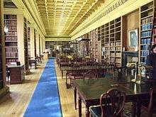
| Advocates' Library |
Parliament Square, Old Town |
14 December 1970 |
|
55°56′56″N 3°11′30″W / 55.948873°N 3.191579°W / 55.948873; -3.191579 (Advocates' Library) |
|
51179 |
 Upload another image
|
| Blackie House |
North Bank Street and Wardrop's Court, Old Town |
14 December 1970 |
|
55°57′00″N 3°11′36″W / 55.949916°N 3.193276°W / 55.949916; -3.193276 (Blackie House) |
|
51522 |
 Upload another image
|
| Royal Lyceum Theatre |
Grindlay Street |
12 December 1974 |
|
55°56′49″N 3°12′15″W / 55.94698°N 3.204187°W / 55.94698; -3.204187 (Royal Lyceum Theatre) |
|
30031 |
 Upload another image
See more images
|
| 1–3 Ramsay Garden |
|
14 December 1970 |
|
55°56′58″N 3°11′47″W / 55.949373°N 3.196494°W / 55.949373; -3.196494 (1–3 Ramsay Garden) |
|
29593 |
 Upload another image
|
| 4–10 Ramsay Garden |
|
14 December 1970 |
|
55°56′58″N 3°11′47″W / 55.949373°N 3.196494°W / 55.949373; -3.196494 (4–10 Ramsay Garden) |
|
29594 |
|
| 11 and 12 Ramsay Garden |
|
14 December 1970 |
|
55°56′57″N 3°11′49″W / 55.949244°N 3.196843°W / 55.949244; -3.196843 (11 and 12 Ramsay Garden) |
|
29595 |
|
| Patrick Geddes Hall (Part) |
1 Mound Place |
14 December 1970 |
|
55°56′59″N 3°11′45″W / 55.949595°N 3.195845°W / 55.949595; -3.195845 (Patrick Geddes Hall (Part)) |
|
29379 |
|
| Patrick Geddes Hall (Part) |
2 Mound Place |
14 December 1970 |
|
55°56′59″N 3°11′45″W / 55.949614°N 3.195701°W / 55.949614; -3.195701 (Patrick Geddes Hall (Part)) |
|
29380 |
|
| 11, 12 and 13 North Bank Street |
|
14 December 1970 |
|
55°56′59″N 3°11′38″W / 55.949802°N 3.194009°W / 55.949802; -3.194009 (11, 12 and 13 North Bank Street) |
|
29236 |
|
| Dolphin House |
3, 4 and 5 Hunter Square |
14 December 1970 |
|
55°56′59″N 3°11′18″W / 55.949749°N 3.188339°W / 55.949749; -3.188339 (Dolphin House) |
|
29123 |
|
| Former Skinner's Hall |
2–4 New Skinner's Close |
14 December 1970 |
|
55°56′59″N 3°11′07″W / 55.949732°N 3.185408°W / 55.949732; -3.185408 (Former Skinner's Hall) |
|
28325 |
 Upload another image
|
| Bank of Scotland |
11 Bank Street |
14 December 1970 |
|
55°57′01″N 3°11′35″W / 55.950323°N 3.193033°W / 55.950323; -3.193033 (Bank of Scotland) |
|
28263 |
 Upload another image
See more images
|
| 17–20 Bank |
|
14 December 1970 |
|
55°56′59″N 3°11′35″W / 55.949756°N 3.193143°W / 55.949756; -3.193143 (17–20 Bank) |
|
28264 |
|
| 15 North Bank Street |
|
14 December 1970 |
|
55°56′59″N 3°11′40″W / 55.949781°N 3.194313°W / 55.949781; -3.194313 (15 North Bank Street) |
|
28265 |
|
| 16 North Bank Street |
|
14 December 1970 |
|
55°56′59″N 3°11′40″W / 55.949689°N 3.194454°W / 55.949689; -3.194454 (16 North Bank Street) |
|
28266 |
|
| Abbey Sanctuary |
Abbey Strand |
14 December 1970 |
|
55°57′10″N 3°10′26″W / 55.952861°N 3.173892°W / 55.952861; -3.173892 (Abbey Sanctuary) |
|
28207 |
 Upload another image
|
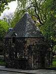
| Thompson's Court |
Abbey Strand |
14 December 1970 |
|
55°57′10″N 3°10′27″W / 55.952868°N 3.174165°W / 55.952868; -3.174165 (Thompson's Court) |
|
28208 |
.jpg) Upload another image
|
| Sacred Heart Church (Roman Catholic) |
28 Lauriston Street |
14 December 1970 |
|
55°56′42″N 3°12′05″W / 55.945137°N 3.20152°W / 55.945137; -3.20152 (Sacred Heart Church (Roman Catholic)) |
|
27266 |
 Upload another image
|
| Charles II Statue |
Parliament Square |
14 December 1970 |
|
55°56′57″N 3°11′26″W / 55.949233°N 3.190533°W / 55.949233; -3.190533 (Charles II Statue) |
|
27851 |
 Upload another image
|
| Calton Old Burial Ground and Monuments |
Regent Road |
19 April 1966 |
|
55°57′15″N 3°11′10″W / 55.954056°N 3.186149°W / 55.954056; -3.186149 (Calton Old Burial Ground and Monuments) |
|
27920 |
 Upload another image
|
| 11–15 Cornwall Street |
|
14 December 1970 |
|
55°56′50″N 3°12′12″W / 55.947122°N 3.203455°W / 55.947122; -3.203455 (11–15 Cornwall Street) |
|
47858 |
 Upload another image
|
| 13–16 Ramsay Garden |
|
14 December 1970 |
|
55°56′57″N 3°11′48″W / 55.949092°N 3.196726°W / 55.949092; -3.196726 (13–16 Ramsay Garden) |
|
48247 |
 Upload another image
|
| 1–6 India Buildings |
Victoria Street |
14 December 1970 |
|
55°56′55″N 3°11′35″W / 55.948517°N 3.193089°W / 55.948517; -3.193089 (1–6 India Buildings) |
|
29868 |
 Upload another image
|
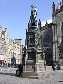
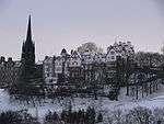
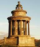
| Burns Monument |
Regent Road |
19 April 1966 |
|
55°57′12″N 3°10′42″W / 55.953457°N 3.178347°W / 55.953457; -3.178347 (Burns Monument) |
|
27801 |
 Upload another image
See more images
|
| 25 Castle Terrace and 17 Cornwall Street |
|
14 December 1970 |
|
55°56′50″N 3°12′12″W / 55.947122°N 3.203455°W / 55.947122; -3.203455 (25 Castle Terrace and 17 Cornwall Street) |
|
28485 |
|
