List of Indiana state historical markers in Marion County
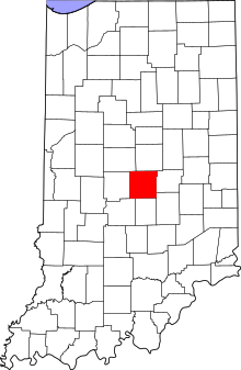
Location of Marion County in Indiana
This is a list of the Indiana state historical markers in Marion County.
This is intended to be a complete list of the official state historical markers placed in Marion County, Indiana, United States by the Indiana Historical Bureau. The locations of the historical markers and their latitude and longitude coordinates are included below when available, along with their names, years of placement, and topics as recorded by the Historical Bureau. There are 62 historical markers located in Marion County.[1]
Historical markers
| Marker title | Image | Year placed | Location | Topics |
|---|---|---|---|---|
| State Capitol[2] | 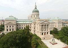 |
1946 | Junction of Capitol Avenue and W. Market Street at the east entrance to the Statehouse in Indianapolis 39°46′7″N 86°9′43″W / 39.76861°N 86.16194°W |
Buildings and Architecture, Government Institutions, Politics |
| Anthony Wayne 1745-1796[3] |  |
1960 | Front lawn of George Washington High School at 2215 W. Washington Street in Indianapolis 39°45′57″N 86°11′59″W / 39.76583°N 86.19972°W |
Military, Early Settlement and Exploration |
| Sarah T. Bolton[4] |  |
1960 | 107 E. Sherman Drive, west of Sarah T. Bolton Park, in Beech Grove 39°43′8″N 86°6′5.6″W / 39.71889°N 86.101556°W |
Arts and Culture, Women |
| Lincoln to the Citizens of Indiana[5] | 1961 | 402 W. Washington Street at its junction with Missouri Street in Indianapolis 39°46′2.6″N 86°9′55.4″W / 39.767389°N 86.165389°W |
Politics, Military | |
| Toll House - Michigan Road[6] |  |
1961 | 4702 N. Michigan Road/U.S. Route 421 in Indianapolis 39°50′29.4″N 86°11′20.4″W / 39.841500°N 86.189000°W |
Transportation, Business, Industry, and Labor |
| Camp Morton 1861-1865[7] |  |
1962 | 1900 block of N. Alabama Street at the Herron-Morton Place Historic Park in Indianapolis 39°47′35″N 86°9′8″W / 39.79306°N 86.15222°W |
Military |
| Brig. General Benjamin Harrison 1833-1901[8] |  |
1963 | President Benjamin Harrison Home at 1230 N. Delaware Street in Indianapolis 39°47′3″N 86°9′15″W / 39.78417°N 86.15417°W |
Politics, Military |
| Civil War Arsenal 1861-1864[9] | 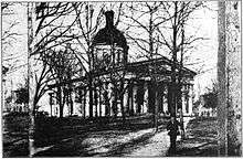 |
1964 | Statehouse in Indianapolis 39°46′7.5″N 86°9′42.2″W / 39.768750°N 86.161722°W |
Military |
| Home of Charles Warren Fairbanks May 11, 1852 - June 4, 1918[10] | 1966 | In the front lawn of a gated establishment at the junction of 30th and Meridian Streets in Indianapolis 39°48′35″N 86°9′25″W / 39.80972°N 86.15694°W |
Politics | |
| The Central Canal[11] |  |
1966 | Junction of Illinois Street and Westfield Boulevard 39°51′18″N 86°9′36″W / 39.85500°N 86.16000°W |
Transportation, Business, Industry, and Labor |
| Milestones in Nursing[12] | 1968 | 1001 W. 10th Street at the Nursing Museum entrance at Wishard Hospital in Indianapolis 39°46′48.3″N 86°10′33″W / 39.780083°N 86.17583°W |
Women, Science, Medicine, and Inventions | |
| Mary Bryan, Pioneer Woman[13] | 1975 | Junction of Pine Street and Southport Road at the cemetery in Southport 39°39′54.5″N 86°6′59″W / 39.665139°N 86.11639°W |
Women, Early Settlement and Exploration | |
| Indianapolis Motor Speedway[14] | 1975 | 4790 W. 16th Street at the Indianapolis Motor Speedway Hall of Fame Museum in Indianapolis 39°47′23″N 86°14′1″W / 39.78972°N 86.23361°W |
Sports, Special Events, Science, Medicine, and Inventions | |
| Former U.S. Arsenal[15] | 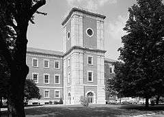 |
1976 | Western edge of the Arsenal Technical High School campus in Indianapolis 39°46′30″N 86°7′59″W / 39.77500°N 86.13306°W |
Military |
| Crown Hill[16] |  |
1976 | 738 W. 38th Street in Crown Hill Cemetery, along the road between the chapel/crypt and the 38th Street overpass, in Indianapolis 39°49′32″N 86°10′22.6″W / 39.82556°N 86.172944°W |
Cemetery |
| Woodruff Place[17] |  |
1976 | Junction of Woodruff Cross Drive and Woodruff Middle Drive on the median, south of the fountain, in Indianapolis 39°46′39″N 86°7′42.4″W / 39.77750°N 86.128444°W |
Historic District, Neighborhoods, and Towns, Buildings and Architecture |
| [The Indianapolis Times][18] | 1979 | 300 block of W. Maryland Street at Capitol Avenue in Indianapolis 39°45′57″N 86°9′44″W / 39.76583°N 86.16222°W |
Newspapers and Media | |
| First Presbyterian Church of Southport[19] | 1983 | 6200 McFarland Road at the Banta Road junction in Southport 39°40′23″N 86°6′40″W / 39.67306°N 86.11111°W |
Religion | |
| William Forsyth 1854-1935[20] | 1984 | Junction of N. Emerson and E. Washington Streets at Brown's Corner Park in Indianapolis 39°46′13″N 86°5′3″W / 39.77028°N 86.08417°W |
Arts and Culture | |
| Macedonian Tribune[21] | 1990 | Southeastern corner of the junction of West and Washington Streets in Indianapolis 39°46′1.4″N 86°10′0.4″W / 39.767056°N 86.166778°W |
Newspapers and Media, Immigration and Ethnic Groups | |
| North Meridian Street Historic District[22] | 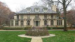 |
1991 | Junction of Westfield Boulevard and N. Meridian Street in Indianapolis 39°51′28″N 86°9′26.5″W / 39.85778°N 86.157361°W |
Historic District, Neighborhoods, and Towns |
| North Meridian Street Historic District[23] | 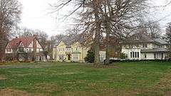 |
1991 | Junction of 40th and N. Meridian Streets in Indianapolis 39°49′45″N 86°9′24.6″W / 39.82917°N 86.156833°W |
Historic District, Neighborhoods, and Towns |
| Crispus Attucks High School[24] | 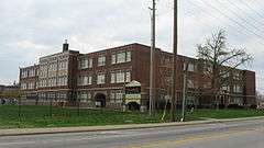 |
1992 | 1140 Dr. Martin Luther King, Jr. Street in Indianapolis 39°46′58″N 86°10′7″W / 39.78278°N 86.16861°W |
African American, Education, Buildings and Architecture |
| North Western Christian University[25] | 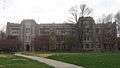 |
1992 | 1325 N. College Avenue, on the eastern side of the street north of the Interstate 65 overpass, in Indianapolis 39°47′5.6″N 86°8′40.4″W / 39.784889°N 86.144556°W |
Education, Religion |
| Site of Golden Hill Totem Pole[26] | 1992 | Totem Lane in the Golden Hill neighborhood of Indianapolis 39°49′6″N 86°11′6″W / 39.81833°N 86.18500°W |
Arts and Culture, American Indian/Native American | |
| Site of the Central Canal[27] | 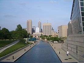 |
1992 | At the Central Canal, behind the North State Office Building at 100 N. Senate Avenue, in Indianapolis 39°46′10″N 86°9′56″W / 39.76944°N 86.16556°W |
Transportation, Business, Industry, and Labor |
| Ransom Place Historic District[28] | 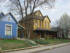 |
1993 | 830 Dr. Martin Luther King, Jr. Street in Indianapolis 39°46′50″N 86°10′6″W / 39.78056°N 86.16833°W |
Historic District, Neighborhoods, and Towns, African American |
| Willard Park[29] | 1993 | Willard Park at 1901 E. Washington Street in Indianapolis 39°46′2″N 86°7′42″W / 39.76722°N 86.12833°W |
Education | |
| Indiana School for the Blind[30] | 1994 | Northern side of the entrance for 7725 N. College Avenue in Indianapolis 39°53′41″N 86°8′39″W / 39.89472°N 86.14417°W |
Education, Government Institutions | |
| Indiana Avenue[31] | 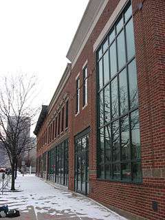 |
1994 | On a traffic island at the southeastern corner of the junction of West Street and Indiana Avenue in Indianapolis 39°46′31″N 86°9′59.32″W / 39.77528°N 86.1664778°W |
African American, Historic District, Neighborhoods, and Towns |
| Bulgarian Orthodox Church[32] | 1995 | On the campus of Indiana University – Purdue University Indianapolis at 226 N. Blackford Street in Indianapolis 39°46′16.6″N 86°10′13″W / 39.771278°N 86.17028°W |
Religion, Immigration and Ethnic Groups | |
| Joseph W. Summers Memorial Bridge[33] |  |
1995 | Eastern side of Meridian Street on the southeastern corner of its bridge over Fall Creek in Indianapolis 39°48′11″N 86°9′23.4″W / 39.80306°N 86.156500°W |
Transportation, Buildings and Architecture, Politics |
| Joseph W. Summers Memorial Bridge[34] |  |
1995 | Western side of Meridian Street on the northwestern corner of its bridge over Fall Creek in Indianapolis 39°48′13″N 86°9′24.3″W / 39.80361°N 86.156750°W |
Transportation, Buildings and Architecture |
| The Old Northside[35] |  |
1995 | 1456 Central Avenue in Indianapolis 39°47′13″N 86°8′58.4″W / 39.78694°N 86.149556°W |
Historic District, Neighborhoods, and Towns, Buildings and Architecture |
| The Old Northside[36] |  |
1995 | Junction of 12th and Delaware Streets in Indianapolis 39°46′59″N 86°9′15″W / 39.78306°N 86.15417°W |
Historic District, Neighborhoods, and Towns, Buildings and Architecture |
| Fort Benjamin Harrison[37] |  |
1996 | Otis Avenue between Hess and Lawton Roads in Indianapolis 39°51′26″N 86°0′57.2″W / 39.85722°N 86.015889°W |
Military, Historic District, Neighborhoods, and Towns |
| Bates-Hendricks House[38] | 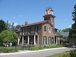 |
1996 | 1526 S. New Jersey Street along the median north of Lincoln Street in Indianapolis 39°44′46.5″N 86°9′2″W / 39.746250°N 86.15056°W |
Buildings and Architecture, Politics |
| Indiana Federation of Colored Women's Clubs[39] | 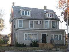 |
1997 | 2034 N. Capitol Avenue in Indianapolis 39°47′38.6″N 86°9′42″W / 39.794056°N 86.16167°W |
African American, Women |
| Romanian Orthodox Church[40] | 1998 | White River State Park at the northeastern corner of the Blackford Street bridge over the Central Canal in Indianapolis 39°46′10″N 86°10′12″W / 39.76944°N 86.17000°W |
Immigration and Ethnic Groups, Religion | |
| Lockerbie Square[41] | 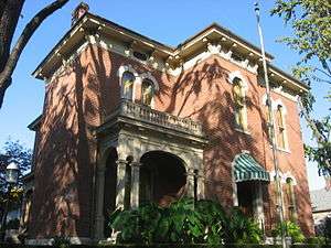 |
1998 | Junction of Lockerbie and N. East Streets in Indianapolis 39°46′19.4″N 86°8′55.4″W / 39.772056°N 86.148722°W |
Historic District, Neighborhoods, and Towns, Buildings and Architecture |
| German Greenhouses and Truck Gardens[42] | 1998 | Bluff Park, at the junction of Bluff Road and Hanna Avenue in Indianapolis 39°42′26″N 86°10′12″W / 39.70722°N 86.17000°W |
Immigration and Ethnic Groups, Nature and Natural Disasters, Business, Industry, and Labor, Agriculture | |
| Indianapolis Fire Department / Bowen-Merrill Fire[43] | 1999 | 2 W. Washington Street in Indianapolis 39°46′2″N 86°9′31.5″W / 39.76722°N 86.158750°W |
Government Institutions, Nature and Natural Disasters | |
| Athenaeum[44] | 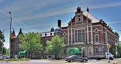 |
1999 | 401 E. Michigan Street in Indianapolis 39°46′25″N 86°9′0″W / 39.77361°N 86.15000°W |
Immigration and Ethnic Groups, Buildings and Architecture |
| Market Street Temple[45] | 1999 | 435 E. Market Street in Indianapolis 39°46′5.6″N 86°8′59″W / 39.768222°N 86.14972°W |
Religion, Immigration and Ethnic Groups | |
| Holy Rosary - Danish Church Historic District[46] | 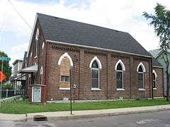 |
2000 | Southeastern corner of the junction of S. East Street and S. Stevens Street in Indianapolis 39°45′28″N 86°8′57.4″W / 39.75778°N 86.149278°W |
Immigration and Ethnic Groups, Historic District, Neighborhoods, and Towns |
| Widows and Orphans Friends' Society[47] | 2003 | Eastern side of Capitol Avenue, ½ block south of its junction with 14th Street, in Indianapolis 39°47′8.4″N 86°9′40″W / 39.785667°N 86.16111°W |
Women | |
| Greek Orthodox Church[48] |  |
2003 | West Street beside the Indiana Historical Society at 450 W. Ohio Street in Indianapolis 39°46′14″N 86°10′0″W / 39.77056°N 86.16667°W |
Religion, Immigration and Ethnic Groups |
| Brookville Road[49] | 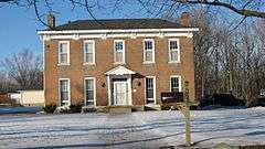 |
2004 | 10622 Brookville Road in Indianapolis 39°44′22.4″N 85°58′41″W / 39.739556°N 85.97806°W |
Transportation, Business, Industry, and Labor |
| John Muir in Indianapolis[50] |  |
2004 | On a grassy triangle at the former site of Osgood, Smith & Co. near the junction of Illinois and Merrill Streets in Indianapolis 39°45′31.5″N 86°9′36.6″W / 39.758750°N 86.160167°W |
Nature and Natural Disasters, Politics |
| Marion County Girl Scouts[51] | 2004 | Irvington Presbyterian Church at 55 Johnson Avenue in Indianapolis 39°46′9″N 86°4′19″W / 39.76917°N 86.07194°W |
Women, Arts and Culture | |
| Zerelda G. Wallace[52] | 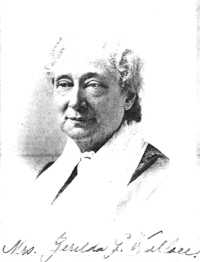 |
2004 | Central Christian Church at 701 N. Delaware Street in Indianapolis 39°46′37″N 86°9′13″W / 39.77694°N 86.15361°W |
Women, Religion |
| 28th Regiment USCT[53] | 2004 | Junction of Virginia Avenue and McCarty Street in Indianapolis 39°45′26″N 86°8′42″W / 39.75722°N 86.14500°W |
African American, Military | |
| Robert F. Kennedy on Death of Martin L. King[54] |  |
2005 | King Park at the junction of 17th Street and Broadway in Indianapolis 39°47′25.4″N 86°8′45.6″W / 39.790389°N 86.146000°W |
Politics, African American |
| Calvin Fletcher[55] | 2006 | Junction of Virginia Avenue and East Street in Indianapolis 39°45′39″N 86°8′57″W / 39.76083°N 86.14917°W |
Historic District, Neighborhoods, and Towns, African American, Military | |
| John Freeman[56] | 2006 | Next to the Landmark Center, on the western side of Pennsylvania Street between 10th and 11th Streets, in Indianapolis 39°41′54″N 86°9′21″W / 39.69833°N 86.15583°W |
Underground Railroad, African American, Government Institutions | |
| 1907 Indiana Eugenics Law[57] | 2007 | Eastern lawn of the Indiana State Library at 140 N. Senate Avenue in Indianapolis 39°46′11″N 86°9′49″W / 39.76972°N 86.16361°W |
Science, Medicine, and Inventions, Legal | |
| Ovid Butler, Sr.[58] | 2007 | 1306 North Park Avenue in Indianapolis 39°47′4″N 86°8′52″W / 39.78444°N 86.14778°W |
Education, Newspapers and Media | |
| St. Vincent's Infirmary[59] | 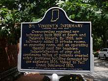 |
2007 | 536 E. Vermont Street in Indianapolis 39°46′22.6″N 86°8′52″W / 39.772944°N 86.14778°W |
Medicine |
| The Lincoln Funeral Train[60] |  |
2009 | Southern lawn of the Indiana Statehouse at 200 W. Washington Street in Indianapolis 39°46′3″N 86°9′46″W / 39.76750°N 86.16278°W |
Government Institutions, Politics, Special Events |
| Bethel African Methodist Episcopal Church[61] |  |
2009 | 414 W. Vermont Street in Indianapolis 39°46′23″N 86°9′57″W / 39.77306°N 86.16583°W |
African American, Buildings & Architecture, Education & Libraries, Military, Religion, Underground Railroad |
| Marshall "Major" Taylor[62] |  |
2009 | Junction of 38th Street and the Monon Trail, across from the Indiana State Fairgrounds, in Indianapolis 39°49′31″N 86°8′23″W / 39.82528°N 86.13972°W |
African American, Sports |
| Indianapolis Propylaeum[63] | 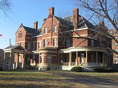 |
2009 | In front of the Propylaeum at 1410 N. Delaware Street in Indianapolis 39°47′11″N 86°9′16″W / 39.78639°N 86.15444°W |
Women, Buildings & Architecture, Arts & Culture |
See also
- List of Indiana state historical markers
- National Register of Historic Places listings in Marion County, Indiana
References
- ↑ "Indiana Historical Markers by County". State of Indiana. Retrieved 2012-03-15.
- ↑ State Capitol, Indiana Historical Bureau, n.d. Accessed 2012-03-14.
- ↑ Anthony Wayne 1745-1796, Indiana Historical Bureau, n.d. Accessed 2012-03-14.
- ↑ Sarah T. Bolton, Indiana Historical Bureau, n.d. Accessed 2012-03-14.
- ↑ Lincoln to the Citizens of Indiana, Indiana Historical Bureau, n.d. Accessed 2012-03-14.
- ↑ Toll House - Michigan Road, Indiana Historical Bureau, n.d. Accessed 2012-03-14.
- ↑ Camp Morton 1861-1865, Indiana Historical Bureau, n.d. Accessed 2012-03-14.
- ↑ Brig. General Benjamin Harrison 1833-1901, Indiana Historical Bureau, n.d. Accessed 2012-03-14.
- ↑ Civil War Arsenal 1861-1864, Indiana Historical Bureau, n.d. Accessed 2012-03-14.
- ↑ Home of Charles Warren Fairbanks May 11, 1852 - June 4, 1918, Indiana Historical Bureau, n.d. Accessed 2012-03-14.
- ↑ The Central Canal, Indiana Historical Bureau, n.d. Accessed 2012-03-14.
- ↑ Milestones in Nursing, Indiana Historical Bureau, n.d. Accessed 2012-03-14.
- ↑ Mary Bryan, Pioneer Woman, Indiana Historical Bureau, n.d. Accessed 2012-03-14.
- ↑ Indianapolis Motor Speedway, Indiana Historical Bureau, n.d. Accessed 2012-03-14.
- ↑ Former U.S. Arsenal, Indiana Historical Bureau, n.d. Accessed 2012-03-14.
- ↑ Crown Hill, Indiana Historical Bureau, n.d. Accessed 2012-03-14.
- ↑ Woodruff Place, Indiana Historical Bureau, n.d. Accessed 2012-03-14.
- ↑ [The Indianapolis Times], Indiana Historical Bureau, n.d. Accessed 2012-03-14.
- ↑ First Presbyterian Church of Southport, Indiana Historical Bureau, n.d. Accessed 2012-03-14.
- ↑ William Forsyth 1854-1935, Indiana Historical Bureau, n.d. Accessed 2012-03-14.
- ↑ Macedonian Tribune, Indiana Historical Bureau, n.d. Accessed 2012-03-14.
- ↑ North Meridian Street Historic District, Indiana Historical Bureau, n.d. Accessed 2012-03-14.
- ↑ North Meridian Street Historic District, Indiana Historical Bureau, n.d. Accessed 2012-03-14.
- ↑ Crispus Attucks High School, Indiana Historical Bureau, n.d. Accessed 2012-03-14.
- ↑ North Western Christian University, Indiana Historical Bureau, n.d. Accessed 2012-03-14.
- ↑ Site of Golden Hill Totem Pole, Indiana Historical Bureau, n.d. Accessed 2012-03-14.
- ↑ Site of the Central Canal, Indiana Historical Bureau, n.d. Accessed 2012-03-14.
- ↑ Ransom Place Historic District, Indiana Historical Bureau, n.d. Accessed 2012-03-14.
- ↑ Willard Park, Indiana Historical Bureau, n.d. Accessed 2012-03-14.
- ↑ Indiana School for the Blind, Indiana Historical Bureau, n.d. Accessed 2012-03-14.
- ↑ Indiana Avenue, Indiana Historical Bureau, n.d. Accessed 2012-03-14.
- ↑ Bulgarian Orthodox Church, Indiana Historical Bureau, n.d. Accessed 2012-03-14.
- ↑ Joseph W. Summers Memorial Bridge, Indiana Historical Bureau, n.d. Accessed 2012-03-14.
- ↑ Joseph W. Summers Memorial Bridge, Indiana Historical Bureau, n.d. Accessed 2012-03-14.
- ↑ The Old Northside, Indiana Historical Bureau, n.d. Accessed 2012-03-14.
- ↑ The Old Northside, Indiana Historical Bureau, n.d. Accessed 2012-03-14.
- ↑ Fort Benjamin Harrison, Indiana Historical Bureau, n.d. Accessed 2012-03-14.
- ↑ Bates-Hendricks House, Indiana Historical Bureau, n.d. Accessed 2012-03-14.
- ↑ Indiana Federation of Colored Women's Clubs, Indiana Historical Bureau, n.d. Accessed 2012-03-14.
- ↑ Romanian Orthodox Church, Indiana Historical Bureau, n.d. Accessed 2012-03-14.
- ↑ Lockerbie Square, Indiana Historical Bureau, n.d. Accessed 2012-03-14.
- ↑ German Greenhouses and Truck Gardens, Indiana Historical Bureau, n.d. Accessed 2012-03-14.
- ↑ Indianapolis Fire Department / Bowen-Merrill Fire, Indiana Historical Bureau, n.d. Accessed 2012-03-14.
- ↑ Athenaeum, Indiana Historical Bureau, n.d. Accessed 2012-03-14.
- ↑ Market Street Temple, Indiana Historical Bureau, n.d. Accessed 2012-03-14.
- ↑ Holy Rosary - Danish Church Historic District, Indiana Historical Bureau, n.d. Accessed 2012-03-14.
- ↑ Widows and Orphans Friends' Society, Indiana Historical Bureau, n.d. Accessed 2012-03-14.
- ↑ Greek Orthodox Church, Indiana Historical Bureau, n.d. Accessed 2012-03-14.
- ↑ Brookville Road, Indiana Historical Bureau, n.d. Accessed 2012-03-14.
- ↑ John Muir in Indianapolis, Indiana Historical Bureau, n.d. Accessed 2012-03-14.
- ↑ Marion County Girl Scouts, Indiana Historical Bureau, n.d. Accessed 2012-03-14.
- ↑ Zerelda G. Wallace, Indiana Historical Bureau, n.d. Accessed 2012-03-14.
- ↑ 28th Regiment USCT, Indiana Historical Bureau, n.d. Accessed 2012-03-14.
- ↑ Robert F. Kennedy on Death of Martin L. King, Indiana Historical Bureau, n.d. Accessed 2012-03-14.
- ↑ Calvin Fletcher, Indiana Historical Bureau, n.d. Accessed 2012-03-14.
- ↑ John Freeman, Indiana Historical Bureau, n.d. Accessed 2012-03-14.
- ↑ 1907 Indiana Eugenics Law, Indiana Historical Bureau, n.d. Accessed 2012-03-14.
- ↑ Ovid Butler, Sr., Indiana Historical Bureau, n.d. Accessed 2012-03-14.
- ↑ St. Vincent's Infirmary, Indiana Historical Bureau, n.d. Accessed 2012-03-14.
- ↑ The Lincoln Funeral Train, Indiana Historical Bureau, n.d. Accessed 2012-03-14.
- ↑ Bethel African Methodist Episcopal Church, Indiana Historical Bureau, n.d. Accessed 2012-03-14.
- ↑ Marshall "Major" Taylor, Indiana Historical Bureau, n.d. Accessed 2012-03-14.
- ↑ Indianapolis Propylaeum, Indiana Historical Bureau, n.d. Accessed 2012-03-14.
External links
Municipalities and communities of Marion County, Indiana, United States | ||
|---|---|---|
| Cities | ||
| Town | ||
| Townships | ||
| Included towns (see Unigov) | ||
| Footnotes | ‡This populated place also has portions in an adjacent county or counties | |
This article is issued from Wikipedia - version of the 8/9/2016. The text is available under the Creative Commons Attribution/Share Alike but additional terms may apply for the media files.