List of Indiana state historical markers in Steuben County
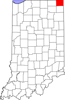
Location of Steuben County in Indiana
This is a list of the Indiana state historical markers in Steuben County.
This is intended to be a complete list of the official state historical markers placed in Steuben County, Indiana, United States, by the Indiana Historical Bureau. The locations of these historical markers, and their latitude and longitude coordinates, are included below when available, along with their names, years of placement, and topics as recorded by the Historical Bureau. There are 2 historical markers located in Steuben County.[1]
Historical markers
| Marker title | Image | Year placed | Location | Topics |
|---|---|---|---|---|
| Fremont Indiana[2] | 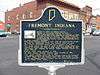 |
1976 | Northwestern corner of the junction of Toledo (State Road 120 and Wayne (State Road 827) Streets at the site of the old town pump in Fremont 41°43′51.4″N 84°55′58.6″W / 41.730944°N 84.932944°W |
Historic District, Neighborhoods, and Towns, American Indian/Native American |
| Indiana's Northern Boundary Line[3] | 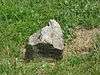 |
2000 | 4.7 miles east of Fremont at the junction of State Road 120 and County Road 775E, along the southern shore of Clear Lake 41°43′35.4″N 84°50′45.6″W / 41.726500°N 84.846000°W |
Early Settlement and Exploration, Government Institutions |
See also
- List of Indiana state historical markers
- National Register of Historic Places listings in Steuben County, Indiana
References
- ↑ "Indiana Historical Markers by County". State of Indiana. Retrieved 2012-03-15.
- ↑ Fremont Indiana, Indiana Historical Bureau, n.d. Accessed 2012-03-14.
- ↑ Indiana's Northern Boundary Line, Indiana Historical Bureau, n.d. Accessed 2012-03-14.
External links
Municipalities and communities of Steuben County, Indiana, United States | ||
|---|---|---|
| City | ||
| Towns | ||
| Townships | ||
| Unincorporated communities |
| |
| Footnotes | ‡This populated place also has portions in an adjacent county or counties | |
This article is issued from Wikipedia - version of the 8/9/2016. The text is available under the Creative Commons Attribution/Share Alike but additional terms may apply for the media files.