List of earthquakes in Pakistan

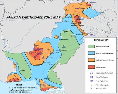
Earthquake hazard zones of Pakistan
Pakistan is situated at the north western side of the Indian subcontinent and overlaps both with the Indian and the Eurasian tectonic plates. Its Sindh and Punjab provinces lie on the northwestern corner of the Indian plate while Balochistan and most of the Khyber-Pakhtunkhwa lie within the Eurasian plate which mainly comprises the Iranian plateau, some parts of the Middle East and Central Asia. Therefore, it has a history of earthquakes. The Northern Areas and Azad Kashmir lie mainly in Central Asia along the edge of the Indian plate and hence are prone to violent earthquakes where the two tectonic plates collide.
The following is a list of major earthquakes affecting Pakistan.
| Date, Time |
Latitude/Longitude |
M |
Deaths |
Notes |
District/Province |
Title |
|---|
| 893-894 [1] |
24°50′N 67°50′E / 24.83°N 67.83°E / 24.83; 67.83 |
8 |
150,000 |
|
Shahbandar, Sindh |
|
| 2 May 1668 [1] |
24°50′N 67°30′E / 24.83°N 67.5°E / 24.83; 67.5 |
7.6 |
50,000 |
|
Shahbandar, Sindh |
|
| 16 June 1819 [2] |
23°36′N 69°36′E / 23.600°N 69.600°E / 23.600; 69.600 |
7.5 |
3,200 |
|
Allahbund, Sindh |
1819 Rann of Kutch |
| 24 September 1827 [3] |
31°34′N 74°21′E / 31.57°N 74.35°E / 31.57; 74.35 |
7.8 |
1,000 |
|
Lahore, Punjab |
|
| 24 January 1852 [3] |
29°18′N 68°54′E / 29.3°N 68.9°E / 29.3; 68.9 |
8 |
|
|
Kahan, Balochistan |
|
| 22 January 1865 [4] |
34°00′N 71°33′E / 34°N 71.55°E / 34; 71.55 |
6 |
|
|
Peshawar |
|
| 1883 |
|
|
|
|
Jhalawan, Balochistan |
|
| 1889 [4] |
27°45′N 67°10′E / 27.75°N 67.17°E / 27.75; 67.17 |
8 |
|
|
Jhalawan, Balochistan |
|
| 20 December 1892 [4] |
30°50′N 66°31′E / 30.83°N 66.52°E / 30.83; 66.52 |
6.8 |
|
Chaman Fault |
Qilla Abdullah, Balochistan |
|
| 21 October 1909 [5] |
29°02′N 67°48′E / 29.03°N 67.8°E / 29.03; 67.8 |
7 |
100 |
|
Sibi, Balochistan |
|
| 24 August 1931 [5] |
30°23′N 67°41′E / 30.38°N 67.68°E / 30.38; 67.68 |
7 |
|
|
Sharigh Valley, Balochistan |
|
| 27 August 1931 [5] |
29°55′N 67°15′E / 29.91°N 67.25°E / 29.91; 67.25 |
7.4 |
|
|
Mach, Balochistan |
|
| 31 May 1935 at 21:56 UTC |
28°52′0″N 66°23′0″E / 28.86667°N 66.38333°E / 28.86667; 66.38333 |
7.7 |
30,000 - 60,000 |
|
Ali Jaan, Balochistan |
1935 Quetta |
| 28 November 1945 at 05:26 PST [6] |
25°09′N 63°29′E / 25.15°N 63.48°E / 25.15; 63.48 |
8.1 |
4,000 |
Tsunami |
Balochistan |
1945 Balochistan |
| 28 December 1974, at 12:11 UTC |
35°06′N 72°54′E / 35.100°N 72.900°E / 35.100; 72.900 |
6.2 |
5,300 |
17,000 injured |
Hunza, Hazara and Swat districts; Northwest Frontier Province |
1974 Hunza |
| 8 October 2005 at 08:50:38 |
34°29′35″N 73°37′44″E / 34.49306°N 73.62889°E / 34.49306; 73.62889 |
7.6 or 7.8 |
80,000 |
3.5 million people homeless |
Azad Kashmir, Islamabad & North West Frontier Province |
2005 Kashmir |
| 29 October 2008 at 04:09 |
30°39′11″N 67°19′23″E / 30.65306°N 67.32306°E / 30.65306; 67.32306 |
6.4 |
215 |
120,000 homeless |
Ziarat District, Quetta |
2008 Pakistan |
| 18 January 2011 at 20:23:17 UTC |
28°49′37″N 63°58′26″E / 28.827°N 63.974°E / 28.827; 63.974 |
7.2 |
|
|
|
2011 Pakistan |
| 24 September 2013 at 11:29:47 UTC |
26°57′N 65°30′E / 26.95°N 65.5°E / 26.95; 65.5 |
7.7 |
825 |
|
Awaran District, Balochistan |
2013 Balochistan [7] |
| 28 September 2013 at 07:34 UTC |
27°14′N 65°34′E / 27.24°N 65.56°E / 27.24; 65.56 |
6.8 |
400 |
|
Awaran District, Balochistan |
|
| 8 May 2014 at 22:51:15 UTC [8] |
26°23′13″N 68°21′29″E / 26.387°N 68.358°E / 26.387; 68.358 |
4.5 |
50[9] |
|
Sindh |
2014 Pakistan |
| 26 October 2015 09:09:32.70 UTC [10] |
36°26′N 70°43′E / 36.44°N 70.72°E / 36.44; 70.72 |
7.5 |
363 |
1,200 injuries |
Gilgit-Baltistan and Khyber Pakhtunkhwa[11] |
October 2015 Hindu Kush |
| 25 December 2015 |
|
6.3 |
40 |
88 injuries |
Gilgit-Baltistan and Khyber Pakhtunkhwa |
December 2015 Hindu Kush |
References
- 1 2 Quittmeyer & Jacob 1979, p. 805
- ↑ Oldham, R. (1926) "The Cutch (Kachh) earthquake of 16th June 1819 with a revision of the great earthquake of 12th June 1897" Memoirs of Geological Survey of India 46: pp. 1–77
- 1 2 Quittmeyer & Jacob 1979, p. 806
- 1 2 3 Quittmeyer & Jacob 1979, p. 807
- 1 2 3 Quittmeyer & Jacob 1979, p. 792
- ↑ Quittmeyer & Jacob 1979, p. 795
- ↑ USGS. "M7.7 - 61km NNE of Awaran, Pakistan". United States Geological Survey.
- ↑ "M4.5 - 8km SSE of Daur, Pakistan". United States Geological Survey. 8 May 2014. Retrieved 31 May 2015.
- ↑ "2 killed, 50 injured in S. Pakistan quake". worldbulletin. 9 May 2014. Retrieved 31 May 2015.
- ↑ USGS. "M7.5 - 45km N of `Alaqahdari-ye Kiran wa Munjan, Afghanistan". United States Geological Survey.
- ↑ "Earthquake death toll rises to 363 in Pakistan". Samaa TV. Retrieved 5 January 2016.
Sources
External links
