List of historic places in Richmond County, Nova Scotia

This is a list of historic places in Richmond County, Nova Scotia.
List of historic places
| Name | Address | Municipality | PC | Coordinates | IDF | IDP | IDM | |
Image |
|---|---|---|---|---|---|---|---|---|---|
| Chapel Island National Historic Site of Canada | 233 Chapel Island Rd. | Chapel Island | B2E | 45°41′33″N 60°45′51″W / 45.6925°N 60.7642°W | 3216 | 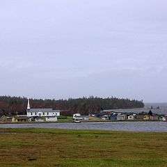 | |||
| Captain James Embree House | 209 Granville Street | Port Hawkesbury | B9A | 45°36′59″N 61°21′54″W / 45.6165°N 61.3651°W | 3555 |  | |||
| Flynn-Cutler-Robichaud House | 694 Lower Road | Arichat | B0E | 45°30′39″N 61°00′48″W / 45.5107°N 61.0132°W | 5323 | | |||
| Fort Toulouse Archaeological Site - BjCf-02 | Battery Provincial Park | St. Peter's | B0E | 45°39′24″N 60°52′01″W / 45.6568°N 60.8669°W | 7087 | | |||
| LeNoir Forge | 712 Lower Road | Arichat | B0E | 45°30′37″N 61°00′42″W / 45.5103°N 61.0116°W | 2806 | | |||
| Leonard House | 36 Manse Road | West Bay | B0E | 45°42′24″N 61°10′07″W / 45.7066°N 61.1686°W | 12015 | | |||
| Lockmaster's House | St. Peters Canal National Historic Site | St. Peter's | B0E | 45°39′31″N 60°51′53″W / 45.6586°N 60.8648°W | 4771 | | |||
| MacAskill House | 7 MacAskill Drive | St. Peter's | B0E | 45°39′20″N 60°52′41″W / 45.6555°N 60.8781°W | 7334 | | |||
| The Morrison House | 3258 West Bay Highway | St. George's Channel | B0E | 45°42′54″N 61°03′12″W / 45.7149°N 61.0532°W | 3067 | | |||
| Notre Dame de l'Assomption | 2292 No. 206 Highway | Arichat | B0E | 45°30′36″N 61°01′57″W / 45.5101°N 61.0326°W | 6526 | | |||
| Port Toulouse Archaeological Site - BjCf-03 | Battery Provincial Park | St. Peter's | B0E | 45°39′24″N 60°52′01″W / 45.6567°N 60.8669°W | 7010 | | |||
| St. Peters Canal National Historic Site of Canada | Highway 4 | St. Peter's | B0E | 45°39′18″N 60°52′10″W / 45.6551°N 60.8695°W | 4487 | 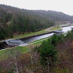 | |||
| St. Peters National Historic Site of Canada | The isthmus of St. Peter's | St. Peter's | B0E | 45°39′00″N 60°51′58″W / 45.6501°N 60.8662°W | 12764 | |
See also
| Wikimedia Commons has media related to Cultural heritage monuments in Nova Scotia. |
- List of historic places in Nova Scotia
- List of National Historic Sites of Canada in Nova Scotia
- Heritage Property Act (Nova Scotia)
This article is issued from Wikipedia - version of the 12/4/2013. The text is available under the Creative Commons Attribution/Share Alike but additional terms may apply for the media files.