List of provinces of the Netherlands
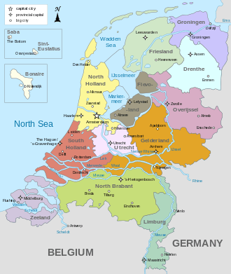
Map of the Netherlands, with provinces and capital cities
- See also Provinces of the Netherlands
Population, area and density, sortable on each field
| Province | Population (2004 estimate) |
Area (km²) | Density | GDP (2003, PPS in mil. €) |
GDP per cap. (2003, in €) |
|---|---|---|---|---|---|
| South Holland | 3,453,000 | 2,860 | 1,207.3 | 95,868 | 27,825 |
| North Holland | 2,583,900 | 2,660 | 971.4 | 65,295 | 27,169 |
| Utrecht | 1,159,200 | 1,356 | 854.9 | 38,355 | 33,148 |
| Limburg | 1,143,000 | 2,167 | 527.5 | 28,038 | 24,585 |
| North Brabant | 2,406,900 | 4,938 | 487.4 | 65,295 | 27,169 |
| Gelderland | 1,967,600 | 4,995 | 393.9 | 45,043 | 22,942 |
| Overijssel | 1,105,800 | 3,337 | 331.4 | 25,854 | 23,441 |
| Flevoland | 356,400 | 1,426 | 249.9 | 6,915 | 19,439 |
| Groningen | 575,900 | 2,344 | 245.7 | 18,496 | 32,245 |
| Zeeland | 378,300 | 1,792 | 211.1 | 9,354 | 24,706 |
| Friesland | 642,500 | 3,361 | 191.2 | 13,989 | 21,830 |
| Drenthe | 482,300 | 2,652 | 181.9 | 10,323 | 21,427 |
| Netherlands | 16,254,800 | 41,525 | 391.4 | 440,167 | 27,132 |
This article is issued from Wikipedia - version of the 10/24/2015. The text is available under the Creative Commons Attribution/Share Alike but additional terms may apply for the media files.