Wayne National Forest
| Wayne National Forest | |
| U.S. National Forest | |
 Wayne National Forest sign | |
| Named for: Anthony Wayne [1] | |
| Country | United States |
|---|---|
| State | Ohio |
| Counties | Athens, Gallia, Hocking, Jackson, Lawrence, Monroe, Morgan, Noble, Perry, Scioto, Vinton, Washington |
| Ranger Districts | Athens (Athens Unit), Athens (Marietta Unit), Ironton |
| Coordinates | 39°30′0″N 82°0′0″W / 39.50000°N 82.00000°WCoordinates: 39°30′0″N 82°0′0″W / 39.50000°N 82.00000°W |
| Highest point | Knob near Oliver Run [2] |
| - location | east of Antioch, Ohio |
| - elevation | 1,368 ft (417.0 m) |
| - coordinates | 39°39′38″N 80°58′51″W / 39.66056°N 80.98083°W |
| Lowest point | Ohio River [2] |
| - location | north of Millersport, Ohio |
| - elevation | 523 ft (159.4 m) |
| - coordinates | 38°33′10″N 82°17′39″W / 38.55278°N 82.29417°W |
| Area | 240,101 acres (97,165 ha) [3] |
| - Proclamation Boundary | 832,147 acres (336,758 ha) [3] |
| Established | December 1992 [4] |
| - Wayne Purchase Unit | November 1934 [4] |
| - Wayne-Hoosier PU | December 1949 [5] |
| - Wayne-Hoosier NF | September 1951 [4] |
| Owner | US Forest Service |
| IUCN category | VI - Managed Resource Protected Area |
| Headquarters | Nelsonville, Ohio |
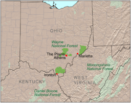 Location of Wayne National Forest
| |
| Wikimedia Commons: Wayne National Forest | |
| Website: Wayne National Forest | |
The Wayne National Forest is located in the south-eastern part of the US state of Ohio, in the Unglaciated Allegheny Plateau. It is the only national forest in Ohio. Forest headquarters are located between The Plains and Nelsonville, Ohio, on US Route 33, overlooking the Hocking River.
The originally forested land was cleared for agricultural and lumbering use in the late 18th and 19th century, but years of poor timbering and agricultural practices led to severe erosion and poor soil composition. The Wayne National Forest was started as part of a reforestation program.[6]
The forest comprises three administrative and purchase units: Athens, Marietta, and Ironton. Many of the lands included in the forest are former coal-mining lands, and much of this land is owned by the federal government without the mineral rights, those having been retained by former owners.
As of January 2012, the forest has 240,101 acres (972 km2) in federal ownership within a proclamation boundary of 832,147 acres (3,368 km2).[3]
- The Athens Unit is located in Athens, Hocking, Morgan, Perry, and Vinton Counties, and includes 67,224 acres (272 km²) as of 2002. It features the Wildcat Hollow Trail, a hiking trail just northeast of Burr Oak State Park in Morgan County; the Stone Church Horse Trail in Perry County; the Utah Ridge Recreation Area in Athens County, and the Dorr Run ATV Trails in Hocking County.
- The Marietta Unit is located in Monroe, Noble and Washington Counties, and includes 63,381 acres (256 km²) as of 2002, with over half of the total being within Washington County.
- The Ironton Unit is located in Gallia, Jackson, Lawrence and Scioto Counties, and includes 99,049 acres (401 km²) as of 2002, with over two-thirds of the total being within Lawrence County.
The area of Ohio included within the Forest is based on late Paleozoic geology, heavy in sandstones and shales, including redbeds, with many coal beds. The topography is typically very rugged, with elevation changes typically in the 200–400-foot range.
The North Country Trail passes through several areas of the Wayne, in which it is coincident with the Buckeye Trail and the American Discovery Trail.
References
- ↑ "Origin of Eastern Region Forest Names". U.S. Forest Service. Retrieved June 27, 2011.
- 1 2 Highest and lowest elevations determined using Google Earth Digital Elevation Model and Wayne National Forest boundary data on January 19, 2009.
- 1 2 3 "Land Areas of the National Forest System" (PDF). U.S. Forest Service. January 2012. Retrieved June 30, 2012.
- 1 2 3 "History". Wayne National Forest. Archived from the original on January 19, 2009. Retrieved January 19, 2009.
- ↑ "History". USDA Forest Service, Eastern Region. Archived from the original on January 19, 2009. Retrieved January 19, 2009.
- ↑ Mangus, Michael; Herman, Jennifer L. (2008). Ohio Encyclopedia. North American Book Dist LLC. p. 570. ISBN 978-1-878592-68-2.
External links
- Wayne National Forest Official Website
- A Forest Returns: The Success Story of Ohio's Only National Forest –- oral history on the beginnings of the Wayne.
- Economic Analysis of the 2006 Wayne National Forest Plan – a critical analysis of future USFS plans for the Wayne