Lone Tree Township, Clay County, Iowa
| Lone Tree Township | |
|---|---|
| Township | |
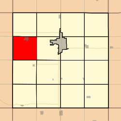 Location in Clay County | |
| Coordinates: 43°07′37″N 095°19′41″W / 43.12694°N 95.32806°WCoordinates: 43°07′37″N 095°19′41″W / 43.12694°N 95.32806°W | |
| Country |
|
| State |
|
| County | Clay |
| Area | |
| • Total | 35.35 sq mi (91.55 km2) |
| • Land | 35.34 sq mi (91.52 km2) |
| • Water | 0.01 sq mi (0.03 km2) 0.03% |
| Elevation | 1,398 ft (426 m) |
| Population (2000) | |
| • Total | 860 |
| • Density | 24.3/sq mi (9.4/km2) |
| GNIS feature ID | 0468302 |
Lone Tree Township is a township in Clay County, Iowa, USA. As of the 2000 census, its population was 860.
History
Lone Tree Township was created in 1877.[1] Lone Tree Township takes its name from a large elm tree that was a local landmark on the prairie.[2]
Geography
Lone Tree Township covers an area of 35.35 square miles (91.6 km2) and contains one incorporated settlement, Everly. According to the USGS, it contains one cemetery, Lone Tree.
The stream of Sewer Creek runs through this township.
Notes
- ↑ Gillespie, Samuel (1909). History of Clay County, Iowa: From Its Earliest Settlement to 1909. S. J. Clarke Publishing Company. p. 60.
- ↑ Gillespie, Samuel (1909). History of Clay County, Iowa: From Its Earliest Settlement to 1909. S. J. Clarke Publishing Company. p. 66.
References
External links
Municipalities and communities of Clay County, Iowa, United States | ||
|---|---|---|
| Cities | ||
| Townships | ||
This article is issued from Wikipedia - version of the 11/3/2016. The text is available under the Creative Commons Attribution/Share Alike but additional terms may apply for the media files.