Luang Prabang
| Louangphabang ຫຼວງພະບາງ Luang Phabang, Luang Prabang | |
|---|---|
| City | |
|
Panorama of south-east Louangphabang | |
 Louangphabang Location in Laos | |
| Coordinates: 19°53′N 102°08′E / 19.883°N 102.133°E | |
| Country |
|
| Admin. division | Louangphabang Province |
| Admin. division | Louangphabang District |
| Government | |
| • Type | Local Committee for World Heritage Louangphabang[1] |
| Population | |
| • Total | 55,027 |
| Time zone | UTC+07:00 |
| Post Code | 06000[2] |
| Website | http://tourismluangprabang.org/ |
| Town of Luang Prabang | |
|---|---|
| Name as inscribed on the World Heritage List | |
 | |
| Type | Cultural |
| Criteria | ii, iv, v |
| Reference | 479 |
| UNESCO region | Asia |
| Inscription history | |
| Inscription | 1995 (19th Session) |
Louangphabang[3][4][5][6] (Lao: ຫລວງພະບາງ) or Luang Phabang[7][8][9][10] (pronounced [lǔaŋ pʰa.bàːŋ]), commonly transliterated into Western languages from pre 1975 Lao spelling ຫຼວງພຣະບາງ (ຣ = silent r) as Luang Prabang,[11][12][13] literally meaning: "Royal Buddha Image", is a city[14] in north central Laos, consisting of 58 adjacent villages, of which 33 comprise the UNESCO Town Of Luang Prabang World Heritage Site.[15][16] It was listed in 1995 for unique and "remarkably" well preserved architectural, religious and cultural heritage, a blend of the rural and urban developments over several centuries, including the French colonial influences during the 19th and 20th centuries.[17] The centre of the city consists of 4 main roads and is located on a peninsula at the confluence of the Nam Khan and Mekong River. The town is well known for its numerous Buddhist temples and monasteries. Every morning, hundreds of monks from the various monasteries walk through the streets collecting alms. One of the major landmarks in the city is mount Phou si; a large steep hill which despite the constrained scale of the city, is 150 metres (490 ft) high; a steep staircase leads to Wat Chom Si shrine and an overlook of the city and the rivers.[18][19]
The city was formerly the capital of a kingdom of the same name. It had also been known by the ancient name of Chiang Thong.[20] It was the royal capital and seat of government of the Kingdom of Laos, until the communist takeover in 1975. The city is part of Luang Prabang District of Luang Prabang Province and is the capital and administrative centre of the province. It lies approximately 300 km (190 mi) north of the capital Vientiane. Currently, the population of the city as a whole is roughly 56,000 inhabitants with the UNESCO protected site being inhabited by around 24,000.[15][21][22]
History
Muang Sua was the old name of Luang Prabang following its conquest in 698 CE by a Tai prince, Khun Lo. Khun Lo had been awarded the town by his father, Khun Borom, who is associated with the Lao legend of the creation of the world, which the Lao share with the Shan and other peoples of the region. Khun Lo established a dynasty whose fifteen rulers reigned over an independent Muang Sua for nearly a century.
In the second half of the 8th century, Nan-chao intervened frequently in the affairs of the principalities of the middle Mekong Valley, resulting in the occupation of Muang Sua in 709. Nan-chao princes or administrators replaced the aristocracy of Tai overlords. Dates of the occupation are not known, but it probably ended well before the northward expansion of the Khmer empire under Indravarman I (r. 877–89) and extended as far as the territories of Sipsong Panna on the upper Mekong.
In the meantime, the Khmers founded an outpost at Xay Fong near Vientiane, and Champa expanded again in southern Laos, maintaining its presence on the banks of the Mekong until 1070. Chanthaphanit, the local ruler of Xay Fong, moved north to Muang Sua and was accepted peacefully as ruler after the departure of the Nan-chao administrators. Chanthaphanit and his son had long reigns, during which the town became known by the Tai name Xieng Dong Xieng Thong.
The dynasty eventually became involved in the squabbles of a number of principalities. Khun Chuang, a warlike ruler who may have been a Kammu (alternate spellings include Khamu and Khmu) tribesman, extended his territory as a result of the warring of these principalities and ruled from 1128 to 1170. Khun Chuang, a single family ruled over a far-flung territory and reinstituted the Siamese administrative system of the 7th century. At some point, Theravada Buddhism was subsumed by Mahayana Buddhism.
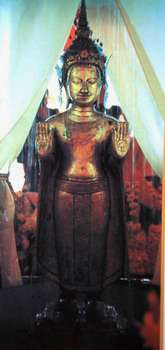
Xieng Dong Xieng Thong experienced a brief period of Khmer suzerainty under Jayavarman VII from 1185 to 1191. By 1180 the Sipsong Panna had regained their independence from the Khmers, however, and in 1238 an internal uprising in the Khmer outpost of Sukhothai expelled the Khmer overlords. Xieng Dong Xieng Thong in 1353 became the capital of the Lan Xang kingdom. In 1359 the Khmer king from Angkor gave the Phra Bang to his son-in-law, the first Lang Xang monarch Fa Ngum (1353-1373); to provide Buddhist legitimacy both to Fa Ngum's rule and by extension to the sovereignty of Laos and was used to spread Theravada Buddhism in the new kingdom. The capital name was changed to Luangphabang, where it was kept, named after the Buddha image.[23]:225–226 The capital was moved in 1560 by King Setthathirath I to Vientiane, which remains the capital today.

In 1707, Lan Xang fell apart because of a dynastic struggle and Luang Prabang became the capital of the independent Kingdom of Luang Phrabang. When France annexed Laos, the French recognised Luang Prabang as the royal residence of Laos. Eventually, the ruler of Luang Prabang became synonymous with the figurehead of Laos. When Laos achieved independence, the king of Luang Prabang, Sisavang Vong, became the head of state of the Kingdom of Laos.[24]
World War II

The town was the scene of many events during and in the aftermath of World War II and it was occupied by several foreign countries during the war (Vichy France, Thailand, Imperial Japan, Free France, and Nationalist China). Initially the Vichy French controlled the city but lost it to Thai forces following the Franco-Thai War of 1940–1941. On 9 March 1945, a nationalist group declared Laos once more independent, with Luang Prabang as its capital but on 7 April 1945 two battalions of Japanese troops occupied the city.[25] The Japanese attempted to force Sisavang Vong (the King of Luang Phrabang) to declare Laotian independence but on 8 April he instead simply declared an end to Laos' status as a French protectorate. The King then secretly sent Prince Kindavong to represent Laos to the Allied forces and Sisavang Vatthana as representative to the Japanese.[25] Following Japan's surrender to the Allies Free French forces were sent to reoccupy Laos and entered Luang Prabang on 25 August, at which time the King assured the French that Laos remained a French colonial protectorate.[25] In September the Chinese Nationalist forces arrived to receive the surrender of the remaining Japanese forces but also quickly set about buying up the Laotian opium crop.[25]
Laotian Civil War era
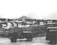
In April and May 1946 the French attempted to recapture Laos by using paratroops to retake Vientiane and Luang Prabang and drive Phetsarath and the Lao Issara ministers out of Laos and into Thailand and Vietnam. During the First Indochina War the Viet Minh and Pathet Lao forces attempted to capture the city several times in 1953 and 1954 but were stopped before they could reach it by French forces.[26] During the Laotian Civil War of the 1950s, 60s, and 70s, a secret American airbase was located at Luang Prabang and it was the scene of fighting. Luang Prabang remained the royal capital until 1975, when the Pathet Lao communist forces seized power with North Vietnamese support and dissolved the ancient monarchy.
Monarchs of Luang Prabang

- Khun Lo, warlord who founded the city
- Fa Ngum, prince of Luang Prabang who founded Lan Xang
- Oun Kham, king who ruled under the French
- Kham Souk (Zakarine), king who ruled under the French and who pushed for independence
- Sisavang Vong, king under the French, and who, when France granted Laos independence, became king of the whole country
Tourism
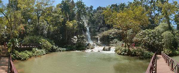
Luang Prabang has both natural and historical sites. Among the natural tourism sites are the Kuang Si Falls, Tat Sae Waterfalls, and Pak Ou Caves. Elephant riding is offered at some sites. Phou Si, in the center of the town, has broad views of the town and river systems, and is a popular place to watch the sun setting over the Mekong River. At the end of the main street of Luang Prabang is a night market where stalls sell shirts, bracelets, and other souvenirs. The Haw Kham Royal Palace Museum and the Wat Xieng Thong temple are among the best known historical sites. The town, particularly the main street, is dotted with many smaller wats such as Wat Hosian Voravihane. Every morning at sunrise, monks walk in a procession through the streets accepting alms offered by local residents, an event popular with tourists but subject to some controversy surrounding tourist etiquette.[27][28] Mountain biking is quite common, with people often biking around the town or to the waterfalls for the day. Down the Mekong River, a 15-minute boat ride from the city centre, Ban Chan (the pottery village [29]) is an interesting place.[30] Luang Prabang received 'Best City' in the Wanderlust Travel Awards 2015.
Gastronomy

Luang Prabang has a rich artistic and culinary history and the city's cooks were hired by the king. Typical local dishes include: O-lam (Or lam, the favourite dish of Luang Prabang locals), Luang Prabang sausage, mokpa (steamed fish), Mekong River moss (served fried) with its chilli sauce (cheo bong).[31]
Transportation
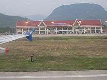
Luang Prabang is served by Luang Prabang International Airport with non-stop flights to adjoining countries.
Luang Prabang is linked by Route 13 with Vang Vieng and Vientiane, and by Route 1 with Muang Xay. Route 13 also connects the city to Cambodia.
The road from Huay Xai to Luang Prabang is poorly maintained, remote, unlit, unmarked and dangerous for the unfamiliar, particularly in the wet season. Buses regularly travel the route in 14–16 hours.[32]
Route 13 from Vientiane, passing Vang Vieng, to Luang Prabang is paved, though the surface is in poor condition at places. It is also relatively narrow, with sharp curves. There are no markings or lighting on the road. Since 2014, a new road connects Kasi (close to Vang Vieng) to Luang Prabang in around 3 hours (compared to 5 hours via Route 13). Several daily buses run from Vientiane to Luang Prabang, taking 11–13 hours.[32]
The Mekong River itself is also an important transportation link. At Chiang Khong it is possible to hire a barge to cross the river. A trip from Huay Xai, across from Thailand, downstream to Luang Prabang takes two days by slow boat, typically with a stop at Pakbeng.
If coming from Vietnam, sleeper buses can be caught from Hanoi to either Luang Prabang or Vang Vieng.
Climate
Luang Prabang features a tropical wet and dry climate (Aw) under the Köppen climate classification. While the city is generally very warm throughout the year, it is noticeably cooler during December and January. Luang Prabang also experiences wet and dry seasons, with the wet season from April until October, and the dry season during the remaining five months. The city receives approximately 1,450 millimetres (57 in) of precipitation annually.
| Climate data for Luang Prabang | |||||||||||||
|---|---|---|---|---|---|---|---|---|---|---|---|---|---|
| Month | Jan | Feb | Mar | Apr | May | Jun | Jul | Aug | Sep | Oct | Nov | Dec | Year |
| Record high °C (°F) | 39.4 (102.9) |
38.9 (102) |
41.1 (106) |
45.0 (113) |
43.9 (111) |
40.0 (104) |
38.9 (102) |
40.0 (104) |
37.8 (100) |
38.3 (100.9) |
36.1 (97) |
32.8 (91) |
45.0 (113) |
| Average high °C (°F) | 27.4 (81.3) |
30.8 (87.4) |
33.1 (91.6) |
34.4 (93.9) |
33.8 (92.8) |
32.4 (90.3) |
31.8 (89.2) |
31.5 (88.7) |
31.9 (89.4) |
30.8 (87.4) |
28.5 (83.3) |
26.3 (79.3) |
31.1 (88) |
| Daily mean °C (°F) | 19.1 (66.4) |
21.6 (70.9) |
24.4 (75.9) |
26.9 (80.4) |
27.7 (81.9) |
27.6 (81.7) |
27.0 (80.6) |
26.7 (80.1) |
26.4 (79.5) |
24.8 (76.6) |
21.9 (71.4) |
18.6 (65.5) |
24.4 (75.9) |
| Average low °C (°F) | 14.2 (57.6) |
15.4 (59.7) |
18.0 (64.4) |
21.4 (70.5) |
23.5 (74.3) |
24.5 (76.1) |
24.0 (75.2) |
23.5 (74.3) |
22.9 (73.2) |
21.1 (70) |
18.0 (64.4) |
14.4 (57.9) |
20.1 (68.2) |
| Record low °C (°F) | 0.6 (33.1) |
7.8 (46) |
10.0 (50) |
13.9 (57) |
17.2 (63) |
13.9 (57) |
19.4 (66.9) |
13.9 (57) |
10.6 (51.1) |
12.8 (55) |
6.1 (43) |
4.4 (39.9) |
0.6 (33.1) |
| Average precipitation mm (inches) | 15.2 (0.598) |
18.6 (0.732) |
29.8 (1.173) |
107.9 (4.248) |
147.2 (5.795) |
258.2 (10.165) |
228.4 (8.992) |
288.6 (11.362) |
172.6 (6.795) |
126.2 (4.969) |
40.1 (1.579) |
10.1 (0.398) |
1,442.9 (56.807) |
| Average rainy days | 2 | 2 | 3 | 9 | 12 | 14 | 16 | 19 | 12 | 6 | 3 | 1 | 99 |
| Average relative humidity (%) | 82 | 77 | 74 | 76 | 81 | 85 | 87 | 89 | 87 | 86 | 84 | 85 | 82.8 |
| Mean monthly sunshine hours | 190.9 | 205.7 | 197.7 | 207.1 | 197.4 | 134.9 | 126.0 | 141.3 | 179.0 | 194.5 | 180.0 | 173.9 | 2,128.4 |
| Source #1: NOAA (1961–1990)[33] | |||||||||||||
| Source #2: Deutscher Wetterdienst (extremes)[34] | |||||||||||||
Sister cities
See also
Gallery

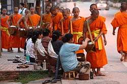 Monks collecting alms at dawn, Luang Prabang
.jpg) Royal Palace, Luang Prabang
Royal Palace, Luang Prabang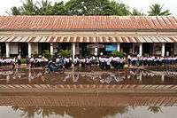 Primary school, Luang Prabang
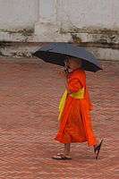 A young monk, Luang Prabang
.jpg) Luang Prabang night market
Luang Prabang night market Buddha images at Vat Visounarath
.jpg) Boats on the Mekong at Luang Prabang
Boats on the Mekong at Luang Prabang
References
- ↑ Sengnaly, Phanthong. "Conference of Local Committee For World Heritage". www.luangprabang-heritage.org. Retrieved 16 June 2016.
- ↑ "Laos Postal Explorer". pe.usps.com. Retrieved 19 October 2016.
- ↑ "Laos". www.state.gov. Retrieved 14 June 2016.
- ↑ Longman School Atlas (Revised Edition). Pearson Education India. ISBN 9788131729076. Retrieved 14 June 2016.
- ↑ Inc, Dorling Kindersley Publishing. Essential Atlas of the World. Dorling Kindersley. ISBN 9780756609641. Retrieved 14 June 2016.
- ↑ McCoy, John. Geo-data: the world geographical encyclopedia. Thomson-Gale. ISBN 9780787655815. Retrieved 15 June 2016.
- ↑ Ricklefs, M. C.; Lockhart, Bruce; Lau, Albert; Reyes, Portia; Aung-Thwin, Maitrii. A New History of Southeast Asia. Palgrave Macmillan. ISBN 9781137015549. Retrieved 15 June 2016.
- ↑ Saqalli, Mehdi; Jourdren, Marine; Maestripieri, Nicolas; Guillerme, Sylvie; Maire, Eric; Soulileuth, Bounsamai; Latsachach, Keoudone; Sounyafong, Phabvilay; Tammahuxsa, Louy; Sengtaheuanghoung, Oloth; Ribolzi, Olivier; Becerra, Sylvia (1 June 2015). "Backward waters, modern waters: Perception-Based Regional Mapping territory uses and water-related sanitary stakes in Luang Phabang area (Lao PDR)". Applied Geography. 60: 184–193. doi:10.1016/j.apgeog.2015.04.001. Retrieved 15 June 2016.
- ↑ Ladwig, Patrice (1 January 2014). "Worshipping Relics and Animating Statues. Transformations of Buddhist statecraft in contemporary Laos". Modern Asian Studies. 49 (06): 1875–1902. doi:10.1017/S0026749X13000486. ISSN 0026-749X. Retrieved 15 June 2016.
- ↑ Lockhart, Bruce M. (1 January 2002). "Review of Laos Culture and Society, ; The Politics of Ritual and Remembrance: Laos since 1975, Grant Evans; Theravadins, Colonialists and Commissars in Laos, , ; Essai d'Anthropologie Politique Sur Le Laos Contemporain: Marché, Socialisme, Et Genies". Journal of Southeast Asian Studies. 33 (1): 180–184. doi:10.1017/s0022463402300080. JSTOR 20072402.
- ↑ Ammon, Ulrich. Sociolinguistics: An International Handbook of the Science of Language and Society. Walter de Gruyter. p. 2010. ISBN 9783110184181. Retrieved 14 June 2016.
- ↑ Ball, Martin J. The Routledge Handbook of Sociolinguistics Around the World: A Handbook. Routledge. ISBN 9781135261047. Retrieved 14 June 2016.
- ↑ Burke, Andrew; Vaisutis, Justine. Laos. Lonely Planet. p. 345. ISBN 9781741045680. Retrieved 14 June 2016.
- ↑ "Luangprabang at a Glance (page 2)" (PDF). Ministry of Public Works and Transport (Laos). Retrieved 15 June 2016.
- 1 2 Application of Information and Communication Technology to Promote Sustainable Development A Case Study: Town of Luang Prabang, Lao PDR (pdf) Tokyo Institute of Technology, Retrieved June 15, 2016
- ↑ "Town of Luang Prabang - Map". UNESCO. Retrieved 15 June 2016.
- ↑ "Town of Luang Prabang - UNESCO World Heritage Centre". UNESCO. Retrieved 16 June 2016.
- ↑ Cavendish 2007, p. 809.
- ↑ Daniel White (28 January 2010). Frommer's Cambodia and Laos. John Wiley & Sons. pp. 270–. ISBN 978-0-470-61583-6. Retrieved 3 January 2013.
- ↑ chiang-tong
- ↑ Promkerd, Prasartthong; Khoprasert, Yuvaluk; Virathavone, Phongthep; Thoummabouth, Manivone; Sirisak, Ouane; Jäkel, Thomas (1 March 2008). "Factors explaining the abundance of rodents in the city of Luang Prabang, Lao PDR, as revealed by field and household surveys". Integrative Zoology. 3 (1): 11–20. doi:10.1111/j.1749-4877.2008.00069.x. ISSN 1749-4877. Retrieved 15 June 2016.
- ↑ "General Overview". www.luangprabang-heritage.org. Retrieved 15 June 2016.
- ↑ Coedès, George (1968). Walter F. Vella, ed. The Indianized States of Southeast Asia. trans.Susan Brown Cowing. University of Hawaii Press. ISBN 978-0-8248-0368-1.
- ↑ http://www.globalurban.org/GUDMag08Vol4Iss1/YamaguchiVaggione.htm
- 1 2 3 4 Savada, Andrea Matles (editor) (1994) "Events in 1945" A Country Study: Laos Federal Research Division, Library of Congress
- ↑ At War in the Shadow of Vietnam: U.S. Military Aid to the Royal Lao Government, 1955 – 1975. pp. 9–10.
- ↑ Luang Prabang Tourism information on respecting the alms giving ceremony
- ↑ http://www.ecotourismlaos.com/dosdont.htm Dos and don'ts in Laos
- ↑ Ban Chan, the pottery village
- ↑ San Francisco Bay Guardian
- ↑ "Lao Food". Sabaidee Laos. Tourism Marketing Department Lao PDR. Retrieved 7 August 2015.
- 1 2 Luang Prabang. Travelfish.org, retrieved 15 Feb 2011
- ↑ "Luangphabang Climate Normals 1961-1990". National Oceanic and Atmospheric Administration. Retrieved 24 January 2016.
- ↑ "Klimatafel von Luang Prabang (Louangphrabang) / Laos" (PDF). Baseline climate means (1961–1990) from stations all over the world (in German). Deutscher Wetterdienst. Retrieved 24 January 2016.
External links
| Wikimedia Commons has media related to Luang Prabang. |
-
 Luang Prabang travel guide from Wikivoyage
 - City portal of Luang Prabang on Luangprabang-laos.com
Coordinates: 19°53′N 102°08′E / 19.883°N 102.133°E
| Attapu | |
|---|---|
| Bokeo | |
| Bolikhamsai | |
| Champassack | |
| Houaphanh | |
| Khammouane | |
| Louang Namtha | |
| Luang Prabang | |
| Oudomxay | |
| Phongsaly | |
| Salavan | |
| Savannakhet | |
| Sekong | |
| Vientiane |
|
| Vientiane (Viengchan) |
|
| Xaignabouli | |
| Xiangkhouang | |
| ||