Lugus, Sulu
| Lugus | |
|---|---|
| Municipality | |
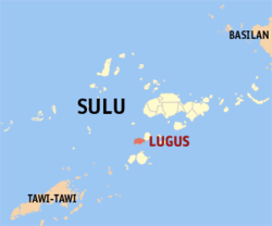 Map of Sulu with Lugus highlighted | |
.svg.png) Lugus Location within the Philippines | |
| Coordinates: 05°42′N 120°49′E / 5.700°N 120.817°ECoordinates: 05°42′N 120°49′E / 5.700°N 120.817°E | |
| Country | Philippines |
| Region | Autonomous Region in Muslim Mindanao (ARMM) |
| Province | Sulu |
| District | 2nd district of Sulu |
| Barangays | 17 |
| Government[1] | |
| • Mayor | Al-zhudurie Lim Asmadun |
| Population (2010)[2] | |
| • Total | 21,897 |
| Time zone | PST (UTC+8) |
| ZIP code | 7411 |
| Dialing code | +63 (0)68 |
| Income class | 5th |
Lugus is a fifth class municipality in the province of Sulu, Philippines. According to the 2010 census, it has a population of 21,897 people.[2]
Barangays
Lugus is politically subdivided into 17 barangays.[2]
- Alu Bus-Bus
- Alu-Duyong
- Bas Lugus
- Gapas Rugasan
- Gapas Tubig Tuwak
- Huwit-huwit Bas Nonok
- Huwit-huwit Proper
- Kutah Parang
- Laha
- Larap
- Lugus Proper
- Mangkallay
- Mantan
- Pait
- Parian Kayawan
- Sibul
- Tingkangan
Demographics
| Population census of Lugus | ||
|---|---|---|
| Year | Pop. | ±% p.a. |
| 1990 | 14,907 | — |
| 1995 | 16,330 | +1.72% |
| 2000 | 18,839 | +3.11% |
| 2007 | 21,650 | +1.94% |
| 2010 | 19,839 | −3.13% |
| Source: National Statistics Office[2] | ||
References
- ↑ "Official City/Municipal 2013 Election Results". Intramuros, Manila, Philippines: Commission on Elections (COMELEC). 1 July 2013. Retrieved 5 September 2013.
- 1 2 3 4 "Total Population by Province, City, Municipality and Barangay: as of May 1, 2010" (PDF). 2010 Census of Population and Housing. National Statistics Office. Retrieved 27 August 2014.
External links
- Philippine Standard Geographic Code
- Philippine Census Information
- Local Governance Performance Management System
 |
Sulu Sea | | ||
| Sulu Sea | |
Tapul | ||
| ||||
| | ||||
| Pandami / Siasi |
Jolo (capital) | |
| Municipalities | |
This article is issued from Wikipedia - version of the 11/1/2016. The text is available under the Creative Commons Attribution/Share Alike but additional terms may apply for the media files.