Lunedale
Coordinates: 54°36′00″N 2°12′32″W / 54.600°N 2.209°W
Lunedale is a dale, or valley, of the east side of the Pennines in England, west of Middleton-in-Teesdale.[1] Its principal villages are Grassholme, Thringarth and West Pasture. There is also a civil parish covering the area with a population (including Holwick) taken at the 2011 census of 187.[2] Lunedale is part of County Durham.
The River Lune flows through Lunedale before reaching Teesdale where it joins the River Tees. The river flows through two reservoirs on the way: Selset Reservoir and Grassholme Reservoir. Running roughly parallel to Lunedale to the south is Baldersdale.
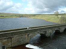
The Pennine Way passes through Lunedale on its way to Middleton-in-Teesdale, and crosses Grassholme Bridge over Grassholme Reservoir.
A former railway viaduct from the now-closed Barnard Castle to Middleton-in-Teesdale line crosses the River Lune just north of Mickleton.
References
- ↑ Ordnance Survey: Landranger map sheet 91 Appleby-in-Westmorland (Brough & Kirkby Stephen) (Map). Ordnance Survey. 2014. ISBN 9780319231302.
- ↑ "Civil parish population 2011". Retrieved 7 July 2015.
North East England Portal | |
| Unitary authorities | |
| Major settlements |
|
| Topics | |