Lungavilla
| Lungavilla | |
|---|---|
| Comune | |
| Comune di Lungavilla | |
 Lungavilla Location of Lungavilla in Italy | |
| Coordinates: 45°2′N 9°5′E / 45.033°N 9.083°ECoordinates: 45°2′N 9°5′E / 45.033°N 9.083°E | |
| Country | Italy |
| Region | Lombardy |
| Province / Metropolitan city | Province of Pavia (PV) |
| Area | |
| • Total | 6.9 km2 (2.7 sq mi) |
| Elevation | 74 m (243 ft) |
| Population (Dec. 2004) | |
| • Total | 2,217 |
| • Density | 320/km2 (830/sq mi) |
| Time zone | CET (UTC+1) |
| • Summer (DST) | CEST (UTC+2) |
| Postal code | 27053 |
| Dialing code | 0383 |
| Website | Official website |
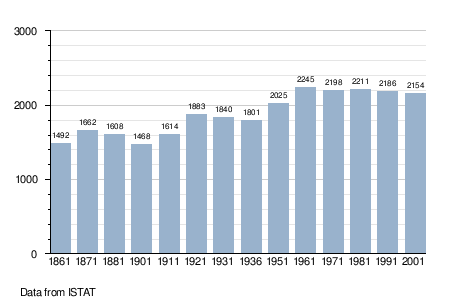
Lungavilla is a comune (municipality) in the Province of Pavia in the Italian region Lombardy, located about 50 km south of Milan and about 15 km southwest of Pavia. As of 31 December 2004, it had a population of 2,217 and an area of 6.9 km².[1]
Lungavilla borders the following municipalities: Castelletto di Branduzzo, Montebello della Battaglia, Pizzale, Verretto, Voghera.
Demographic evolution
Notable People
- Luigi Furini, (1954), poet
References
External links
This article is issued from Wikipedia - version of the 1/31/2015. The text is available under the Creative Commons Attribution/Share Alike but additional terms may apply for the media files.