Macclenny, Florida
| Macclenny, Florida | |
|---|---|
| City | |
|
Top, left to right: Baker County Courthouse, Old Baker County Courthouse, railroad crossing in the historic district, water tower | |
 Location in Baker County and the state of Florida | |
| Coordinates: 30°17′N 82°7′W / 30.283°N 82.117°WCoordinates: 30°17′N 82°7′W / 30.283°N 82.117°W | |
| Country |
|
| State |
|
| County | Baker |
| Government | |
| • Mayor | Gary Dopson |
| Area | |
| • Total | 4.7 sq mi (12.3 km2) |
| • Land | 4.7 sq mi (12.3 km2) |
| • Water | 0 sq mi (0 km2) |
| Elevation | 131 ft (40 m) |
| Population (2010) | |
| • Total | 6,374 |
| • Density | 1,345/sq mi (519.5/km2) |
| Time zone | Eastern (EST) (UTC-5) |
| • Summer (DST) | EDT (UTC-4) |
| ZIP code | 32063 |
| Area code(s) | 904 |
| FIPS code | 12-41950[1] |
| GNIS feature ID | 0286243[2] |
| Website |
www |

Macclenny is a city in Baker County, Florida, United States. The population was 6,374 at the 2010 census,[3] up from 4,459 at the 2000 census. It is the county seat of Baker County.[4]
History

Macclenny was first called Darbyville because most of the land around current-day Macclenny was owned by the Darby family. Carr Bowers McClenny married into the Darby family and then bought most of the land. Darbyville was then known as McClenny. Carr's business in McClenny was in sawmills, turpentine, lumber and land. The name McClenny was changed to the current name of Macclenny because the post office department had a rule against capital letters in the middle of a name. The first post office in Macclenny was then established in 1890. There were settlers in Macclenny as early as 1829 but after the Civil War most of the people settled there. However, in 1888 most of the town residents were killed in a yellow fever epidemic. Residents of the town then increased over time to 4,500.[5]
Geography
Macclenny is located in eastern Baker County at 30°17′N 82°7′W / 30.283°N 82.117°W,[6] 28 miles (45 km) west of downtown Jacksonville. U.S. Route 90 (Macclenny Avenue) runs through the center of town, and Interstate 10 passes through the southern tip of the town, with access from Exit 335 (State Road 121). Lake City is 32 miles (51 km) to the west, and the Florida–Georgia border is 6 miles (10 km) to the north.
According to the United States Census Bureau, the city has a total area of 4.7 square miles (12.3 km2), all of it land.[3]
Demographics
| Historical population | |||
|---|---|---|---|
| Census | Pop. | %± | |
| 1890 | 334 | — | |
| 1900 | 350 | 4.8% | |
| 1910 | 388 | 10.9% | |
| 1920 | 350 | −9.8% | |
| 1930 | 519 | 48.3% | |
| 1940 | 771 | 48.6% | |
| 1950 | 1,177 | 52.7% | |
| 1960 | 2,671 | 126.9% | |
| 1970 | 2,733 | 2.3% | |
| 1980 | 3,851 | 40.9% | |
| 1990 | 3,966 | 3.0% | |
| 2000 | 4,459 | 12.4% | |
| 2010 | 6,374 | 42.9% | |
| Est. 2015 | 6,487 | [7] | 1.8% |
As of the census[1] of 2000, there were 4,459 people, 1,548 households, and 1,140 families residing in the city. The population density was 1,354.9 people per square mile (523.3/km²). There were 1,644 housing units at an average density of 499.5 per square mile (192.9/km²). The racial makeup of the city was 75.89% White, 21.87% African American, 0.36% Native American, 0.67% Asian, 0.07% Pacific Islander, 0.45% from other races, and 0.70% from two or more races. Hispanic or Latino of any race were 2.47% of the population.
There were 1,548 households out of which 38.4% had children under the age of 18 living with them, 49.5% were married couples living together, 20.5% had a female householder with no husband present, and 26.3% were non-families. 23.0% of all households were made up of individuals and 10.7% had someone living alone who was 65 years of age or older. The average household size was 2.70 and the average family size was 3.17.
In the city the population was spread out with 28.9% under the age of 18, 12.4% from 18 to 24, 25.5% from 25 to 44, 18.8% from 45 to 64, and 14.4% who were 65 years of age or older. The median age was 32 years. For every 100 females there were 90 males. For every 100 females age 18 and over, there were 85 males.
The median income for a household in the city was $31,895, and the median income for a family was $37,091. Males had a median income of $26,775 versus $19,573 for females. The per capita income for the city was $14,909. About 17.1% of families and 20.9% of the population were below the poverty line, including 37.4% of those under age 18 and 10.2% of those age 65 or over.
References
- 1 2 "American FactFinder". United States Census Bureau. Retrieved 2008-01-31.
- ↑ "US Board on Geographic Names". United States Geological Survey. 2007-10-25. Retrieved 2008-01-31.
- 1 2 "Geographic Identifiers: 2010 Demographic Profile Data (G001): Macclenny city, Florida". U.S. Census Bureau, American Factfinder. Retrieved October 18, 2013.
- ↑ "Find a County". National Association of Counties. Retrieved 2011-06-07.
- ↑ "McClenny Family Website". mcclenny.org. Retrieved July 16, 2014.
- ↑ "US Gazetteer files: 2010, 2000, and 1990". United States Census Bureau. 2011-02-12. Retrieved 2011-04-23.
- ↑ "Annual Estimates of the Resident Population for Incorporated Places: April 1, 2010 to July 1, 2015". Retrieved July 2, 2016.
- ↑ "Census of Population and Housing". Census.gov. Retrieved June 4, 2015.
External links
| Wikimedia Commons has media related to Macclenny, Florida. |
- City of Macclenny official website
- Baker County Press, newspaper that serves Macclenny, Florida, available for free in full-text with images in Florida Digital Newspaper Library
Municipalities and communities of Baker County, Florida, United States | ||
|---|---|---|
| City | 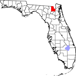 | |
| Town | ||
| Unincorporated communities | ||
| Central city | 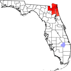 | |
|---|---|---|
| Municipalities over 10,000 population (in 2000) | ||
| Municipalities 1,000-10,000 population (in 2000) |
| |
| Counties | ||