Main Line of Public Works
| Main Line of Public Works | |
|---|---|
|
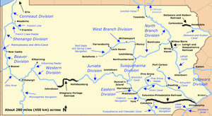
Map of historic Pennsylvania canals and connecting railroads | |
| Specifications | |
| Locks |
168 (The Eastern Division Canal had 14 locks, the Juniata Division 86, and the Western Division 68.) |
| Maximum height above sea level |
2,322 ft (708 m) (Summit of the Allegheny Portage Railroad through Blair Gap) |
| Status | Canals abandoned except for historic and recreational segments. Many railroad segments survive as part of the Keystone Corridor. |
| History | |
| Original owner | Commonwealth of Pennsylvania |
| Date of act | 1826 |
| Construction began | 1828 |
| Date completed | 1834 |
| Date closed | Sold to Pennsylvania Railroad in 1857; last canal segment, near Harrisburg, closed in 1901 |
| Geography | |
| Start point | Philadelphia |
| End point | Pittsburgh |
| Branch(es) | Wiconisco Canal, Kittanning Feeder, Allegheny Outlet |
| Branch of | Pennsylvania Canal |
| Connects to | Delaware River, Schuylkill Canal, Conestoga Navigation, Susquehanna and Tidewater Canal, Codorus Navigation, Union Canal, Susquehanna Division, Allegheny River, Monongahela River, Ohio River, Ashley Planes, Lehigh and Susquehanna Railroad, Lehigh Canal & Delaware Canal |
The Main Line of Public Works was a package of legislation supporting a vision passed in 1826[lower-alpha 1] — a collection of various long proposed canal and road projects that became a canal system (1824 proposals and studies) and later added railroads (amendments in 1828) designed to cross the breadth of Pennsylvania (mainly, southern) with the visionary goal of providing the best commercial means[lower-alpha 2] of transportation between Philadelphia and Pittsburgh. Built between 1826 and 1834 by the Commonwealth of Pennsylvania, it established the Pennsylvania Canal System, the Allegheny Portage Railroad, and the Pennsylvania Canal Commission.
Later amendments substituted a new technology, railroads in place of the 82 miles (132 km) canal that had been planned on the right-of-way of the substitute: the Philadelphia and Columbia Railroad (P&CRR), a new technology, for an envisioned canal link connecting the Delaware River (Philadelphia) to the Susquehanna River that would have proved too costly.[lower-alpha 3]
Historic backstory
Trans-Appalachian settlement had begun in earnest at the close of the French and Indian War (1763), and the British Governments policy of curbing expanded settlement in the colonial mid-west was one cause that created support for the American Revolution (a casus belli, and not just along the American frontiers for those hoping to emigrate into the nearly empty Amerindian lands of the Ohio Country, for the American families were prone to have large families, and Eastern seaboard populations were blooming in the pre-industrialized predominantly Agricultural culture). By the 1810s, population west of the mountains was effectively exploding with new cities seeming to rise every couple of years anchored by 1800s transport hubs (gateway cities) like Brownsville, Pittsburgh, Cincinnati, Buffalo, Detroit, New Orleans, and later by the 1840s, St.Louis, Chicago, and St. Joseph Missouri. The market potential of this burgeoning population was the target of Philadelphia and New Jersey's business class.
In 1823 entrepreneur White made a proposal which would have dammed and created a Ship Navigation allowing deep keeled coastal shipping to reach docks and pickup and tran-ship the coal steadily coming down the Lehigh Canal into Easton, Pennsylvania; the first 60 miles of which down to the Philadelphia suburb town of Bristol would later become the Delaware Canal. An employee of industrialist[lower-alpha 4] Josiah White's had figured out how to get "Rock Coal" to burn properly during the War of 1812 renewing serious interest in exploiting these relatively coal resources. Efforts to improve shipping capabilities on the Schuylkill Navigation was lagging hope when backers took to quarreling over the best way to proceed; disgusted, WHite distanced himself from the project. White went looking for a source of coal in 1815 looked at the mines of the failing and unreliable Lehigh Coal Mine Company—who'd almost managed to drop more coal in the Lehigh than they'd delivered to market since their founding in 1792. After surveying and deciding improving Navigation on the Lehigh could be feasible, returned to lease the operations of that company. Two years later he'd obtained the legal permissions "to ruin himself" fixing up the Lehigh, so founding the Lehigh Navigation Company[lower-alpha 5] and using a quasi-lock of his own design between 1918 & 1820, the works had made sufficient improvements to be able to deliver 365 tons of coal to Easton[lower-alpha 6] late in the year—by 1825 the annual tonnage had climbed to over 28,000 short tons (25,000 t) per annum, and the two overachievers had firmly established anthracite as a reliable inexpensive fuel.
A couple years later, the legislature declined another offer by the Lehigh Coal and Navigation Company (LC&N) which had built the Lehigh Canal with private funds. LC&N was unquestionably one of the most innovative companies of the era, driving the mining, transportation and industrial development of Pennsylvania by example, implementation, and by funding quite a few projects, as well. This new proposal was to build—at the companies expense— the project that would (in concept) become their version of the eventual Delaware Canal (alternatively the 'Delaware Division of the Pennsylvania Canal') built by the states engineering managers a few years later. The route was nearly the same, but the Delaware Canal as the state built it had numerous engineering flaws, including too short locks, and single (one way) locks LC&N's experience and expertise would have mitigated. LC&N had started coal flowing to Philadelphia using short barges it called arks, but was re-doing the Lehigh Canal already to have boats over 120 feet (37 m) and two way traffic with full locks. While some problems were fixable, the lock's design was always a problem until the Canal became the parkland and current haven for pleasure boats.
White and Hazard made the offer in return for a break on tolls, and even included an offer to operate the system at cost—the state garnering all the tolls. This offer too was declined, and in 1827 in a separate amending act, the state authorized the Delaware Canal, which was delayed for a few more years costing LC&N many dollars, until it was finally dug alongside, and generally in sight of the Delaware River between Easton down river to Bristol. When completed in 1832 by the state it also didn't work—having leaking issues and water supply problems like those that plagued the Union Canal and Schuylkill Navigation, and the state needed to hire Josiah White to fix it before it became fully usable in 1834. Lehigh Coal & Navigation Company would operate the Canal into the 1930s, and controlled its resources and those rights attained on the Lehigh until the 1960s when they reverted or conveyed back to the state.
Hence the Canal system was envisioned and built at the urging of New Jersey and Pennsylvanian businessmen, especially Philadelphia's bearing witness to the navigations improving commerce on the Lehigh and Schuylkill Rivers,[lower-alpha 7] though in 1824 both systems needed further development. But the same decision makers were also continually reading the copious press coverage about the progress, the works designs, and engineering feats accomplished or building as the Erie Canal progressed. Philadelphia's luminaries were vying with other coastal cities to become the United States' most important and influential port as the country's population expanded westward to the Ohio Country and Northwest Territory regions. The system would also not only open better access to the newly opened Southeastern Coal Region and the initial mines in the Panther Creek Valley but authorized an extension of the Lehigh Canal up to White Haven, and a railroad connecting that upper canal with the coal sources in the Wyoming Valley. All the eastern projects were to reliably provide clean-burning anthracite coal to eastern cities that had already consumed much of the eastern forests for heating fuel.
List of works
The rail portions of the system were authorized in 1828 by an act of the Pennsylvania General Assembly entitled An act relative to the Pennsylvania Canal, and to provide for the commencement of a Railroad to be constructed at the expense of the state and to be styled "The Pennsylvania Railroad" (Act of March 24, 1828, Pamph. Laws, p. 221).[2][3][4]
Begun with Navigations construction along the Susquehanna and the West Fork of the Susquehanna with surveys for the best route over the barrier of the northern Allegheny Mountains, the system in time ran from Philadelphia on the Delaware estuary westwards across the great plain of southern Pennsylvania (goal of connecting the Susquehanna to New York City via canals) through Harrisburg and across the state to Pittsburgh and connected with other divisions of the Pennsylvania Canal. It consisted of the following principal sections, moving from east to west:[5][6]
- Philadelphia and Columbia Railroad: 82 miles (132 km) from Philadelphia to Columbia near the former ferry site known as Wright's Ferry, in Lancaster County. Originally expected to be a bona fide canal in the 1820s conception, the easternmost leg of the Pennsylvania Canal was to be a continuation of the first funded and more difficult to construct engineering navigations and construction farther west in less populated rural regions. The canal joining the Delaware and Susquehanna rivers was to run across the most populated expanse of Pennsylvania's Great Valley region (and so was delayed politically in part) but its planning was overtaken by the growth of railroad technology, which by the mid-1830s had demonstrated sufficient promise to adopt the new technology for the leg of the capability and funding and construction was shifted to a railroad—it was faster and cheaper to build above ground and make bridges than it was to dig a deep ditch and provide it with reliable water supplies to enable two way barge traffic.
- Eastern Division Canal: 43 miles (69 km) from Columbia to Duncan's Island at the mouth of the Juniata River.
- Juniata Division Canal: 127 miles (204 km) from Duncan's Island to Hollidaysburg
- Allegheny Portage Railroad: 36 miles (58 km) from Hollidaysburg to Johnstown
- Western Division Canal: 103 miles (166 km) from Johnstown to the terminus in Pittsburgh.
The canals reduced travel time between Philadelphia and Pittsburgh from at least 23 days to just four.[7]
The Main Line of Public Works was completed in 1834 and was sold to the Pennsylvania Railroad on June 25, 1857, for $7,500,000. Within a year, the PRR replaced the Philadelphia-Pittsburgh route with an entirely rail-based system.[4][8]
Philadelphia and Columbia Railroad
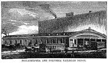

The Philadelphia and Columbia Railroad began in Philadelphia at Broad and Vine Streets, ran north on Broad and west on Pennsylvania Avenue (a segment later taken over and submerged/tunneled over by the Reading Railroad), then headed northwest across the Columbia Bridge over the Schuylkill River. Just after crossing the river, it traveled up the Belmont Plane, an inclined plane in the current location of West Fairmount Park, and continued west across the eastern part of the state to Columbia, where the Columbia Plane headed down to the Susquehanna River. At that point, the eastern division of the canal continued north along the river and then west.
The Northern Liberties and Penn Township Railroad was incorporated in 1829 to build a branch continuing east on Noble Street and Willow Street to the Delaware River. This opened in 1834.[9]
Belmont Plane
The Belmont Plane ran from the Schuylkill River for 2,805 feet (855 m), rising 1 foot (0.3 m) per 15 feet (4.6 m) for a total rise of 187 feet (57 m). Steam-driven cables dragged the railway cars to the top of Belmont Hill.
The Plane was the site of a signal event in railroad history. On July 10, 1836, the Philadelphia-based Norris Locomotive Works drove a 4-2-0 locomotive up the Incline, making it the first steam locomotive to climb an ascending grade while pulling a load. The 14,400-pound (6,500 kg) engine, named George Washington, hauled a load of 19,200 pounds (8,709 kg), including 24 people riding on the tender and one freight car, up the grade at 15 miles (24 km) per hour. So remarkable was this accomplishment that reports in engineering journals doubted its occurrence.[10] Nine days later, the engine repeated the feat in a more formal trial with an even greater load.

In 1850, the state bought the West Philadelphia Railroad, which had been incorporated in 1835 to bypass the Belmont Plane and failed after completing only the section from 52nd Street west to the main line at Rosemont. The state built the rest from 52nd Street east to downtown, but on a different alignment than the one originally planned; the new line, put into operation October 15, 1850,[4] ended at the west end of the Market Street Bridge, from which the City Railroad continued east. The old line, which ran from the Schuylkill River up the Belmont Plane to Ardmore along the route of present-day Montgomery Avenue in Lower Merion Township, was abandoned.
The Columbia Bridge and line east to Broad and Vine Streets were sold to the Philadelphia and Reading Railroad as part of its main line. The Reading acquired the Northern Liberties and Penn Township Railroad in 1870, giving it access to the Delaware River.
The section of the old Pennsylvania Railroad running from Philadelphia west through Chester County and, by extension, the western suburbs of Philadelphia, is still known as the Main Line.
The Columbia Plane, which lowered railway cars down to the Eastern Division Canal along the Susquehanna River, was bypassed in 1840 by a new track alignment.[11]
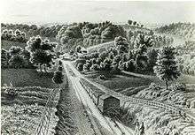
Eastern Division Canal
The Pennsylvania Canal's Eastern Division, which opened in 1833, ran 43 miles (69 km) along the east side of the Susquehanna River between Columbia and Duncan's Island at the mouth of the Juniata River. The canal included 14 locks with an average lift of 7.5 feet (2.3 m). The state originally planned a canal of 24 miles (39 km) running between the Union Canal at Middletown to the Juniata. However, the plan changed in 1828, when the state opted to extend the Eastern Division 19 miles (31 km) further south to connect with the newly decided replacement of a canal by the Philadelphia and Columbia Railroad at historic Wright's Ferry.[12]
Engineers faced complications at the northern end of the Eastern Division Canal, where it met the Juniata Division Canal and the Susquehanna Division Canal at Duncan's Island. Boats had to cross from one side of the Susquehanna River to the other between either the Susquehanna Division or the Juniata Division on the west side and the Eastern Division on the east side. They solved the problem by building a dam 1,998 feet (609 m) long and 8.5 feet (2.6 m) high between the lower end of Duncan's Island and the east bank of the Susquehanna. This formed a pool across which boats could be pulled from a wooden, two-tier towpath bridge at Clark's Ferry. Two Duncan's Island lift locks raised or lowered the boats traveling between the dam pool and the other canals.[12]
Juniata Division Canal
|
Pennsylvania Main Line Canal, Juniata Division, Canal Section | |
|
Pennsylvania Main Line Canal, Juniata Division, April 2010 | |
 | |
| Location | 1.5 mi. section of canal bet. PA RR Main Line and Juniata River, Granville Township, Pennsylvania |
|---|---|
| Area | 13.6 acres (5.5 ha) |
| Built | 1830 |
| Built by | Clinton, DeWitt Jr. |
| Architect | Clinton, DeWitt Jr. |
| Architectural style | Other, Canal |
| NRHP Reference # | 02000069[13] |
| Added to NRHP | February 20, 2002 |

The Juniata Division Canal was approved in segments starting in 1827 with a canal from near Duncan's Island in the Susquehanna River to Lewistown, 40 miles (64 km) upstream. Subsequently, the state agreed to extend the canal to Hollidaysburg and the eastern end of the Allegheny Portage Railroad, 127 miles (204 km) from the Susquehanna. A total of 86 locks were required to overcome a change in elevation of 584 feet (178 m) over the full length of the canal, which opened in 1832.[12]
From the canal basin, westbound boats began their journey by being elevated about 10 feet (3 m) by a lock that brought them to the level of a wooden aqueduct on which they were towed 600 feet (183 m) to the south side of the Juniata. At North's Island, 18 miles (29 km) from the Susquehanna, they were towed by a water powered continuous rope to the north side of the river across a slack water pool formed by a dam. From North's Island to Huntingdon, the river was dammed in three more places to feed water to the canal, and above Huntingdon, 14 more dams were needed to create 16 miles (26 km) of slack water navigation in the river to supplement 22 miles (35 km) of travel in segments of canal. In addition, the state built three reservoirs on Juniata tributaries to keep the upper parts of the canal filled with water.[12]
Remnants
A canal section of 1.5 miles (2.4 km) has been restored near Locust Campground, 3 miles (4.8 km) west of Lewistown. At the western end of the canal, the Hollidaysburg Canal Basin Park has preserved two canal basins and a connecting lock; a museum at the park illustrates how canal boats transferred between the canal and the Allegheny Portage Railroad.[14]
The Pennsylvania Main Line Canal, Juniata Division, Canal Section was added to the National Register of Historic Places in 2002.[13]
Allegheny Portage Railroad

From 1834 until 1854, when the Pennsylvania Railroad Company finished a competing line, the Allegheny Portage Railroad made continuous boat traffic possible over the Allegheny Mountains between the Juniata and Western Division Canals. It followed a 36-mile (58 km) route that included 11 levels, 10 inclined planes fitted with stationary engines that could raise and lower boats and cargo, a 900-foot (270 m), viaduct over the Little Conemaugh River, and many bridges.[15] Infrastructure included 153 drains and culverts.[16] The railroad climbed 1,398 feet (426 m) from the eastern canal basin at Hollidaysburg and 1,171 feet (357 m) from the western basin at Johnstown.[15] At its summit, the railroad reached an elevation of 2,322 feet (708 m) above sea level.[16]

Western Division Canal
|
Western Division-Pennsylvania Canal | |
|
| |
| Location | Along the Conemaugh River, Bolivar, Derry Township, and Fairfield Township |
|---|---|
| Area | 15 acres (6.1 ha) |
| Built | 1830 |
| Built by | Pennsylvania Canal Commission |
| NRHP Reference # | 74001817[13] |
| Added to NRHP | September 17, 1974 |
|
Western Division of the PA Canal | |
|
| |
| Location | Along the Conemaugh River, Bell, Derry, and Loyalhanna Townships |
|---|---|
| Area | 15 acres (6.1 ha) |
| Built | 1830 |
| Built by | White, Canvas; Geddes, James |
| NRHP Reference # | 82001537[13] |
| Added to NRHP | November 14, 1982 |
In 1826, the state legislature authorized the first segment of the Western Division Canal, from Pittsburgh up the Allegheny River to its confluence with the Kiskiminetas River at Freeport. Pittsburgh residents favored a route that would follow the south bank of the Allegheny River and terminate in Pittsburgh, while residents of the borough of Allegheny favored a north bank canal ending in the borough, across the river from Pittsburgh. Eventually, the canal was run along the physically more favorable north bank, but the state agreed to build the main terminal and turning basin in Pittsburgh and a secondary terminal and connecting canal, the Allegheny Outlet, in the borough. Getting the main canal across the Allegheny River into Pittsburgh required an aqueduct of 1,140 feet (347 m), the longest on the Pennsylvania Main Line route. Linking to the Ohio River at Pittsburgh, the Western Division Canal also linked, through a tunnel of 810 feet (250 m) under Grant's Hill in Pittsburgh, with the Monongahela River.[12]
Subsequent Western Division Canal extensions went from Freeport up the Kiskiminetas and Conemaugh Rivers to Blairsville and then to the western end of the Allegheny Portage Railroad at Johnstown. East of Tunnelton, the route went through a canal tunnel of 817 feet (249 m) built to avoid a long loop of the Conemaugh River. The first fully loaded freight boat traveled from Johnstown to Pittsburgh in 1831; the route through Grant's Hill opened in 1832. Over its length of 104 miles (167 km), the canal employed 68 locks, 16 river dams, and 16 aqueducts. From Freeport, a separate extension, the Kittanning Feeder, ran 14 miles (23 km) up the Allegheny River to Kittanning.[12]
Johnstown Flood
The 1889 Johnstown Flood was caused by the failure of the South Fork Dam, part of the Main Line of Public Works. The dam across the Little Conemaugh River in the hills above Johnstown, Pennsylvania, created a two-square-mile (5.2 km2) reservoir. Dubbed Lake Conemaugh, it supplied water to the Western Division Canal. When canal traffic declined, the lake and dam were abandoned, then sold to the Pennsylvania Railroad in 1857; the railroad in turn sold them to private interests. They were purchased by the South Fork Fishing and Hunting Club in 1879, and a private resort was built surrounding the lake. On May 31, 1889, following heavy rains, the South Fork Dam failed, sending 20 million tons (18.2 million cubic meters) of water down the gorge toward Johnstown. More than 2,200 people were killed.[17]
Remnants
The Tunnelview Historical Site shows where in 1830 a canal tunnel of 817 feet (249 m) was built through Bow Ridge to avoid a long bend on the Conemaugh River, 10 miles (16 km) west of Blairsville. Saltsburg Canal Park, where Loyalhanna Creek joins the Conemaugh River to form the Kiskiminetas River, recognizes the canal's economic contribution to Saltsburg.[14]
Points of interest
| Feature | Coordinates | Description |
|---|---|---|
| Philadelphia | 39°57′08″N 75°09′50″W / 39.95222°N 75.16389°W[18] | City at the eastern terminus of the Main Line of Public Works and the Columbia–Philadelphia Railroad |
| Columbia | 40°02′01″N 76°30′16″W / 40.03361°N 76.50444°W[19] | Borough at the western terminus of the Philadelphia and Columbia Railroad and the southern terminus of the Eastern Division Canal |
| Duncan's Island | 40°25′02″N 77°00′33″W / 40.41722°N 77.00917°W.[20] | Island at the northern terminus of the Eastern Division Canal and the eastern terminus of the Juniata Division Canal |
| Lewistown | 40°35′57″N 77°34′17″W / 40.59917°N 77.57139°WCoordinates: 40°35′57″N 77°34′17″W / 40.59917°N 77.57139°W[21] | Borough at the western terminus of the Juniata Division Canal and the eastern terminus of the Allegheny Portage Railroad |
| Hollidaysburg | 40°25′38″N 78°23′20″W / 40.42722°N 78.38889°W[22] | Borough at the western terminus of the Juniata Division Canal and the eastern terminus of the Allegheny Portage Railroad |
| Johnstown | 40°19′36″N 78°55′19″W / 40.32667°N 78.92194°W[23] | City at the western terminus of the Allegheny Portage Railroad and the eastern terminus of the Western Division Canal |
| Pittsburgh | 40°26′26″N 79°59′45″W / 40.44056°N 79.99583°W[24] | City at the western terminus of the Main Line of Public Works and the Western Division Canal |
| Kittanning | 40°48′59″N 79°31′19″W / 40.81639°N 79.52194°W[25] | Borough at the northern terminus of the Kittanning Feeder Canal |
See also
- Allegheny Portage Railroad
- Delaware and Hudson Canal
- Delaware Canal, aka later: Pennsylvania Canal (Delaware Division)
- List of canals in the United States
- Lehigh Canal
- Pennsylvania Canal System
- Pennsylvania Canal, aka later: Pennsylvania Canal (Eastern Division)
- Pennsylvania Canal (North Branch Division)
- Pennsylvania Canal (Susquehanna Division)
- Pennsylvania Canal (West Branch Division)
- IPennsylvania Canal Guard Lock and Feeder Dam, Raystown Branch
- Pennsylvania Canal Tunnel
- Pennsylvania Canal and Limestone Run Aqueduct
Notes
- ↑ The legislation was amended several times, usually to substitute some other means or project as a result of some engineering difficulty or obstacle that was unforeseen and difficult to accomplish notably in 1828, and 1834 which redefined goals and reset funding while authorizing right-of-ways and charters, etcetera.
- ↑ In 1824-1826, the 'best means' of moving both people and cargo meant Water transport, usually by using Mule towed barges compatible with the waterway. Such technologies and systems had been in service for many centuries in the Canals in Europe (old proven technologies) connecting rivers and ports, bypassing marshlands, or even crossing peninsular barriers.
* Towpath Canals were also by far, the fastest way to travel, the commercial drivers. drovers, and infrastructure giving otherwise unobtainable average speeds over long distances, barring competing sea transport with favorable winds—and the endurance to ride for a long, long work day on a given vehicle. If duration or illness became an issue, many locks sprouted pubs, stores, and Inns catering to the travelers and boatmen and the canals were the first travel companies to offer passenger services on regular schedules, and usually provided options jump off with allowances to later continue the journey on a later regularly scheduled barge or boat. - ↑ The canal connecting the Susquehanna to Philadelphia was envisioned south of the Schuylkill Canal (a navigation) transiting through a water gap and through Reading, PA, which barely had enough water, given much of what was available had to be split to the Union Canal, to be reliable during Summer and Autumn. The poor water supply for the Schuylkill Navigation was one reason Josiah White dropped his interest in the project and explored taking over the lackluster Lehigh Coal Mine Company and proposed the navigation improving the navigability of the Lehigh River. The Legislature granted him permission to bankrupt himself on the Lehigh (which had seen its share of mostly publicly funded improvement attempts[1] as well)
- ↑ Wire mill and nail factory owner, Josiah White was the Bill Gates of the 19th century. He built the first suspension bridge across the Schuylkill, for his factories were located near the Falls of the Schuylkill, systematically worked out several ways to effectively use Anthracite coal as a clean fuel, then spent a lifetime building infrastructure to deliver anthracite to the energy consumer, most of which he had to invent, design, develop, and refine along the way.
- ↑ Josiah White and his partner Ezrah Howard seeking other investors found some investors had an opinion that the coal mine had failed long enough under too many managers to have a chance, but the Navigations would work. Others, thought the coal mine was no challenge, but they'd be crazy to back the Navigations. In the end, they formed two companies with minority investors, the Lehigh Coal Company and the Lehigh Navigation Company.
- ↑ White and Hazard had circulated a prospectus with a goal for the Lehigh Navigation Company to regularly deliver ten tons of coal per month by 1824. They'd had to scramble in 1820 to find enough surprised and delighted buyers for no one was expecting anthracite in such quantities.
- ↑ there were at least 17 efforts—most largely publicly funded—to improve navigability of the Schuylkill before 1818
References
- ↑ Alfred Mathews & Ausin N. Hungerford (1884). The History of the Counties of Lehigh & Carbon, Commonwealth of Pennsylvania. Philadelphia: Ancestry.com, Transcribed from the original in April 2004 by Shirley Kuntz.
The task which Josiah White and Erskine Hazard undertook, that of making the Lehigh a navigable stream, was one which had before been several times attempted, and as often abandoned as too expensive and difficult to be successfully carried out. The Legislature was early aware of the importance of the navigation of this stream, and in 1771 passed a law for its improvement. Subsequent laws for the same object were enacted in 1791, 1794, 1798, 1810, 1814, and 1816, and a company had been formed under one of them which expended upwards of thirty thousand dollars in clearing out channels, one of which they attempted to make through the ledges of slate about seven miles above Allentown, though they soon relinquished the work.
- ↑ Churella, Albert J. (2013). The Pennsylvania Railroad: Volume I, Building an Empire, 1846-1917. Philadelphia: University of Pennsylvania Press. pp. 2; 43. ISBN 978-0-8122-4348-2. OCLC 759594295.
- ↑ Compilation of the Laws of Pennsylvania relative to the Internal Improvements: together with the canal and railroad regulations, as established by the Board of Canal Commissioners Harrisburg:Barrett and Parke (1840), pp. 35-42
- 1 2 3 Burgess, George H. and Kennedy, Miles C. (1949), Centennial History of the Pennsylvania Railroad Company, Philadelphia: The Pennsylvania Railroad Company. p. 10, 96
- ↑ "Pennsylvania Canals". Pennsylvania Historical and Museum Commission. Archived from the original on August 18, 2007. Retrieved August 7, 2007.
- ↑ Roberts, Charles S. (1997). Triumph I. Baltimore: Barnard, Roberts, and Company. p. 34. ISBN 0-934118-23-X.
- ↑ "Allegheny Portage Railroad". WQED Multimedia TV.
- ↑ "Sale of the Main Line of Public Works of Pennsylvania" The New York Times, June 26, 1857
- ↑ PRR Chronology, 1834
- ↑ Carter, Charles F. "When Railroads Were New" New York:Henry Holt & Co. (1909) pp. 128-133
- ↑ PRR Chronology, 1836
- 1 2 3 4 5 6 Shank, William H. (1986). The Amazing Pennsylvania Canals, 150th Anniversary Edition. York, Pennsylvania: American Canal and Transportation Center. ISBN 0-933788-37-1.
- 1 2 3 4 National Park Service (2010-07-09). "National Register Information System". National Register of Historic Places. National Park Service.
- 1 2 "Introduction to Pennsylvania's Historic Canals". Pennsylvania Canal Society. Retrieved November 26, 2009.
- 1 2 "The Allegheny Portage Railroad". Pennsylvania Historical and Museum Commission. Retrieved March 24, 2010.
- 1 2 Bianculli, Anthony J. (2003). Trains and Technology: The American Railroad in the 19th Century, Vol. 3, Tracks and Structures. Newark, Del.: University of Delaware Press. p. 48. ISBN 0-87413-802-7. Retrieved March 22, 2009.
- ↑ Frank, Walter Smoter (2004). "The Cause of the Johnstown Flood". Walter Smoter Frank. According to the source, the article is a version of a May 1988 article in Civil Engineering, pp. 63–66
- ↑ "Philadelphia". Geographic Names Information System. United States Geological Survey. August 30, 1990. Retrieved March 22, 2009.
- ↑ "Columbia". Geographic Names Information System. United States Geological Survey. August 2, 1979. Retrieved March 22, 2009.
- ↑ "Duncan Island". Geographic Names Information System. United States Geological Survey. August 2, 1979. Retrieved March 20, 2009.
- ↑ "Lewistown". Geographic Names Information System. United States Geological Survey. August 2, 1979. Retrieved March 22, 2009.
- ↑ "Hollidaysburg". Geographic Names Information System. United States Geological Survey. August 2, 1979. Retrieved March 22, 2009.
- ↑ "Johnstown". Geographic Names Information System. United States Geological Survey. August 2, 1979. Retrieved March 21, 2009.
- ↑ "Pittsburgh". Geographic Names Information System. United States Geological Survey. August 2, 1979. Retrieved March 21, 2009.
- ↑ "Kittanning". Geographic Names Information System. United States Geological Survey. August 2, 1979. Retrieved March 21, 2009.
Further reading
For more on the Philadelphia and Columbia Railroad, see William Hasell Wilson, The Columbia-Philadelphia Railroad and Its Successor (1896). A reprint of this booklet was issued in 1985. See also John C. Trautwine, Jr., The Philadelphia and Columbia Railroad of 1834, in Philadelphia History, Vol. 2, No. 7 (Philadelphia, PA: City History Soc. of Philadelphia, 1925). This is a pamphlet written for The City History Society of Philadelphia and read at the meeting of March 15, 1921.
External links
| Wikimedia Commons has media related to Pennsylvania Main Line of Public Works. |