Wyoming Valley
| Wyoming Valley, PA MSA Metropolitan Statistical Area | ||||||
|---|---|---|---|---|---|---|
| Scranton/Wilkes-Barre | ||||||
| ||||||
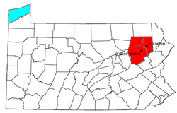 Location of the Scranton–Wilkes-Barre–Hazleton Metro Area within the State of Pennsylvania. | ||||||
| Coordinates: 41°18′N 75°54′W / 41.3°N 75.9°W | ||||||
| Country | United States | |||||
| State(s) | Pennsylvania | |||||
| Largest city | Scranton | |||||
| Other cities |
- Wilkes-Barre - Hazleton - Pittston City (Greater Pittston) | |||||
| Area | ||||||
| • Total | 1,777 sq mi (4,600 km2) | |||||
| Highest elevation | 2,460[1] ft (750 m) | |||||
| Lowest elevation | 400 ft (100 m) | |||||
| Population [2] | ||||||
| • Total | 563,631 | |||||
| • Rank | 95th in the U.S. | |||||
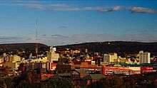
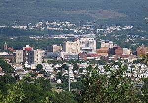


The Wyoming Valley is a historic industrialized region of northeastern Pennsylvania once famous for fueling the industrial revolution in the United States with its many anthracite coal mines. As a metropolitan area, it is known as the Scranton/Wilkes-Barre area, the 95th-largest metropolitan area in the United States. It is called the "Scranton/Wilkes-Barre Metropolitan Area" after its principal cities, Scranton and Wilkes-Barre, and makes up its own unique physiographic province, the Anthracite Valley in the geology of Pennsylvania. Greater Pittston makes up the center of the valley.
The airport(s) for this area are Wilkes-Barre/Scranton International Airport (Avoca) and the Wilkes-Barre Wyoming Valley Airport (Forty Fort). The Wyoming Valley also has professional sports teams; they include the Scranton/Wilkes-Barre Railriders (Baseball AAA), the Wilkes-Barre/Scranton Penguins (Hockey AHL), and the Scranton/Wilkes-Barre Steamers(Basketball Premier Basketball League). Some other attractions are the Mohegan Sun Arena at Casey Plaza in Wilkes-Barre, the Pocono Raceway in Long Pond, PNC Field in Moosic, Mohegan Sun Casino in Plains, the Toyota Pavilion in Scranton, the Wyoming Valley Mall in Wilkes-Barre, the Shoppes at Montage in Moosic, the Steamtown Mall in Scranton, the Viewmont Mall in Scranton/Dickson City, Pennsylvania, and the Montage Mountain Waterpark/Ski Resort in Scranton.
The valley is a crescent-shaped depression, a part of the ridge-and-valley or folded Appalachians. The Susquehanna River occupies the southern part of the valley, which is notable for its deposits of anthracite. These have been extensively mined. Deep mining of anthracite has declined throughout the greater Coal Region, however, due to the greater economics of strip mining. Parts of the local mines had already shut down because some coal beds were on fire and had to be sealed; but the exodus of mining companies came quickly following the legal and political repercussions of the 1959 Knox Mine Disaster—when the roof of the Knox Coal Company's mine under the river collapsed. The Pocono Mountains, a ridgeline away, are often visible from higher elevations to the east and to the southeast of the Wyoming Valley[notes 1]
Metropolitan Statistical Area
The Scranton–Wilkes-Barre–Hazleton, PA Metropolitan Statistical Area covers Lackawanna, Luzerne and Wyoming counties.[3] It had a combined population of 563,936 in 2011 The counties adjacent to the "Wyoming Valley" includes Monroe County (Southeast), Susquehanna County (Northeast), Wayne County (East), Columbia County (West), Bradford County (Northwest), Carbon County (South), Sullivan County (West) and Schuylkill County (Southeast). The area also has the highest percentage of non-Hispanic whites of any U.S. metropolitan area with a population over 500,000, with 96.2% of the population stating their race as white alone and not claiming Hispanic ethnicity.[4]
When metropolitan areas were first defined in 1950, Scranton and Wilkes-Barre were in separate metropolitan areas. Lackawanna County was defined as the Scranton Standard Metropolitan Area, while Luzerne County was defined as the Wilkes-Barre–Hazleton Standard Metropolitan Area. The two metropolitan areas were merged after the 1970 census as the Northeast Pennsylvania Standard Metropolitan Statistical Area, with Monroe County added as a component. It was renamed the Scranton/Wilkes-Barre Metropolitan Statistical Area after the 1980 census, and Columbia and Wyoming counties were added. Hazleton was added as a primary city in the 1990 census, while Monroe County lost its metropolitan status. After the 2000 census, Columbia County lost metropolitan status, while Hazleton was removed as a primary city.
History
The name Wyoming derives from the Lenape Munsee name xwé:wamənk, meaning "at the smaller river hills."[5]
According to the Jesuit Relation of 1635, the Wyoming Valley was inhabited by the Scahentoarrhonon people, an Iroquoian-speaking group; it was then known as the Scahentowanen Valley. By 1744 it was inhabited by Lenape, Mahican, Shawnee and others who had been pushed out of eastern areas by the Iroquois Confederacy. From the 1740s to the 1760s, the valley was the site of Moravian mission work among the Native Americans living there. They envisioned a settlement for Christian Indians. But the violence of the French and Indian War, the North American front of the Seven Years' War, drove these settlers away with David Zeisberger, the Moravian "Apostle to the Indians."
Pennsylvania's and Connecticut's conflicting claims to the territory — King Charles II of England had granted the land to the colony of Connecticut in 1662, and also to William Penn in 1681 — led to military skirmishes known as the Pennamite Wars. After Yankee settlers from Connecticut founded the town of Wilkes-Barre in 1769, armed bands of Pennsylvanians (Pennamites) tried without success to expel them in 1769-70, and again in 1775.
During the American Revolutionary War, the Battle of Wyoming took place here on July 3, 1778, in which more than 300 Revolutionaries died at the hands of Loyalists and their Iroquois allies. The incident was depicted by the Scottish poet Thomas Campbell in his 1809 poem Gertrude of Wyoming. At the time, rebel colonists widely believed that Joseph Brant, a Mohawk chief, had led the Iroquois forces; in the poem, Brant is described as the "Monster Brant" because of the atrocities committed. Later colonists determined that Brant had not been present at this conflict. The popularity of the poem may have led to the state of Wyoming later being named after the valley.
See also
Notes
- ↑ The Poconos being bounded by the Lehigh River Valley on their west side, whose east bank watershed begins on the divide of the Penobscot Knob ridgeline east of the Valley.
References
The following printed resources are in the collection of the Connecticut State Library (CSL):
- Boyd, J. P. The Susquehanna Company, 1753-1803. [CSL call number: F157 .W9 B69 1931]
- Henry, William (ed.). Documents Relating to the Connecticut Settlement in the Wyoming Valley. Bowie, MD: Heritage Books, Inc., 1990 [CSL call number: F157 .W9 D63 1990 v1, 2].
- Joyce, Mary Hinchcliffe. Pioneer Days in the Wyoming Valley. Philadelphia: 1928 [CSL call number: F157 .W9 J89].
- Smith, William. An Examination of the Connecticut Claim to Lands in Pennsylvania: With an Appendix, Containing Extracts and Copies Taken from Original Papers. Philadelphia: Joseph Crukshank, 1774 [CSL call number: Wells Collection F157 .W9 S55].
- Stark, S. Judson. The Wyoming Valley: Probate Records... Wilkes-Barre, PA: Wyoming Historical and Geological Society, 1923 [CSL call number: F157 .W9 S72].
- Warfle, Richard Thomas. Connecticut's Western Colony; the Susquehannah Affair. (Connecticut Bicentennial Series, #32). Hartford, CT: American Revolutionary Bicentennial Commission of Connecticut, 1979 [CSL call number: Conn Doc Am35 cb num 32].
- Wilkes-Barre, Pennsylvania. Wilkes-Barre (the "Diamond City"), Luzerne County, Pennsylvania. Wilkes-Barre, PA: The Committee on Souvenir and Program, 1906 [CSL call number: F159 .W6 W65 1906].
Footnotes
- ↑ "Pennsylvania County High Points". Peakbagger.com. Retrieved January 1, 2007.
- ↑ http://www.census.gov/popest/data/metro/totals/2009/files/CBSA-EST2009-alldata.csv
- ↑ "METROPOLITAN STATISTICAL AREAS AND COMPONENTS". Retrieved May 26, 2007., Office of Management and Budget, 2007-05-11. Accessed 2008-07-30.
- ↑ "Percent Non-Hispanic White, 2000: Metros Ranked by Percent of Population Selecting Race of Non-Hispanic/Latino, White Alone". CensusScope.org. Retrieved 2009-01-28.
- ↑ Bright, William (2004). Native American Place Names of the United States. Norman: University of Oklahoma Press, pg. 576
External links
| Wikisource has original text related to this article: |
- Connecticut's "Susquehanna Settlers"
- History of the Wilkes-Barre area
- Sullivanclinton.com - the full historical context
- Sullivanclinton.com - Wyoming Valley today
Coordinates: 41°15′04″N 75°54′22″W / 41.251°N 75.906°W