Maiella
| Maiella | |
|---|---|
| Monte Amaro | |
 | |
| Highest point | |
| Elevation | 2,795 m (9,170 ft) [1] |
| Prominence | 1,812 m (5,945 ft) [1] |
| Listing | Ultra |
| Coordinates | 42°05′13″N 14°05′15″E / 42.08694°N 14.08750°ECoordinates: 42°05′13″N 14°05′15″E / 42.08694°N 14.08750°E [1] |
| Geography | |
 Mount Amaro Italy | |
| Location | Abruzzo, Italy |
| Parent range | Apennine Mountains |
| Climbing | |
| First ascent | 1873 |
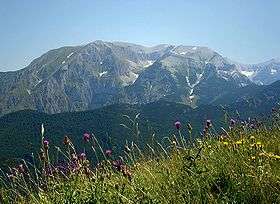
The Maiella (or Majella) is a massif in the Central Apennines, in Abruzzo, central Italy.
Geography
The mountain is located at the boundary between the provinces of Chieti, Pescara and L'Aquila.
The highest peak is Monte Amaro at 2,793 m, the second highest of the entire Apennine range. The massif is at the center of the Maiella National Park.
The Maiella is formed by a compact limestone massif, on which summit are the highest peaks in the group: Monte Amaro 2,793 m, Monte Acquaviva 2,737 m, Monte Focalone 2,676 m, Monte Rotondo 2,656 m, Monte Macellaro 2,646 m, Pesco Falcone 2,546 m, Cima delle Murelle 2,598 m.
Vast plateaus are present up to 2,500 m. The slopes are characterized by steep valleys and gorges, carved out by rivers such as the Orfento, the Foro and others.
Nearby are the Monte Morrone, Monte Porrara and Monti Pizzi groups. The Maiella includes an iced waterfall, known as Il Principiante, located at 1,600 meters and having a height of 25 meters.
Scientific research
The area of the Montagna della Maiella has been subject to a major international geoscientific research Project, TaskForceMajella from 1998 up to 2005.
See also
References
- 1 2 3 "Europe Ultra-Prominences". Peaklist.org. Retrieved 2014-05-24.
![]() Media related to Majella at Wikimedia Commons
Media related to Majella at Wikimedia Commons