Mallawan
| Mallawan | |
|---|---|
| Town | |
| Mallanwan | |
 Mallawan Location in Uttar Pradesh, India | |
| Coordinates: 27°02′32″N 80°08′54″E / 27.0421°N 80.1483°ECoordinates: 27°02′32″N 80°08′54″E / 27.0421°N 80.1483°E | |
| country |
|
| State | Uttar Pradesh |
| District | Hardoi |
| Town | Mallanwan |
| Government | |
| • Type | Municipality (NPP) |
| • Body | Chairman of NPP |
| Area | |
| • Total | 11.43 km2 (4.41 sq mi) |
| Population | |
| • Total | 36,915 |
| Time zone | IST |
| Area code(s) | 05851 |
Mallawan (Hindi:मल्लावां) is a town and municipality (Nagar Palika, NPP)[1] in Hardoi district in the Indian state of Uttar Pradesh. It is also referred to as Mallanwan in Indian Railway records.[2]
Geography
It is located at 27°2'8"N 80°9'6"E[3] and its average elevation is 142 metres. River Ganga passes, touching its border to Kannauj. Mallawan is located 47 km south-east of Hardoi and 92 km from state capital Lucknow.
Demography
Per 2011 census Mallawan had a total population of 36,915, out of which 19,404 (53%) were male and 17,511 (47%) female.[1] It had a literacy rate of 68.71%. It is divided into 25 wards. 57% of the population were Hindus, 42.5% were Muslims, and the rest belonged to other religions.
History
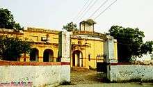
Early Mallawan used to be a Buddhist site. Later it was held by Thateras until it was invaded by Sayyed Salar Masood Gazi in 1033 AD.[4] A wandering saint, Maqdoom Shah, and later his disciple, Misbah-ul-Islam, commonly known as Qazi Bhikari, were appointed qazi of Pargana. In 1765 AD Jesuit missionary and traveller Joseph Tiefenthaler visited and described Mallawan as a small town build of bricks surrounded by many trees. With the advent of British Rule, followed by the annexation of Oudh in 1856, Mallawan was made district headquarter and possessed considerable political importance.[5] During the struggle of 1857 the Raikawars, independence fighters from nearby village Rudamau, burned Mallawan's court house. Conditions worsened, leading to the move of the district headquarter to Hardoi.
Education
Mallawan is home to one of oldest high schools in India, founded in 1857 by Ram Sahai Bajpai as Adarsh Shri Prasad Mahavidyalaya at Bajiganj.[6] B.N. Inter College is situated at Bhagvantnagar. Shree RAm Bhajan Ramesh Chandra Avasthi Inter College is situated at Gangarampur.
Mallawan is home to several colleges which award degree in Agriculture, Art and Science. Patel ShreeTikaram Degree College, affiliated to Kanpur University is situated within town at Kanpur-Farukhabaad highway. Other degree colleges include Divya Kripal degree college situated at a distance of 3 km at Goswa.
Transportation & Tourism
Mallawan is well connected to the road as well as to the railway network. Public and private buses serve routes to Sandila, Kannauj, Lucknow, Kanpur, Hardoi and other locations. The local train station Mallanwan offers connections to Kanpur, Balamau and Sitapur. The closest airports are Chakeri, Kanpur and Lucknow.
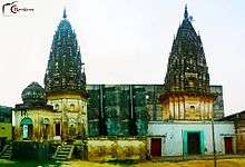
Mallawan features a few touristic sites, including Baba Sunasir Nath temple situated at Kaliyanpur village. Every year, in the month of Shraavana, a huge number of people offer prayers on falling Monday's . A large fair is organized on this occasion. Due to presence of many splendid temples, It is also referred as Choti Kashi. The town is also home to Hazrat Makdoom Shah Babab Misbah Dargah situated at Mohiuddinpur.[7]
References
- 1 2 "Mallawan City Population Census 2011 - Uttar Pradesh". www.census2011.co.in. Retrieved 2016-07-22.
- ↑ "MLW/Mallanwan (1 PFs) Railway Station - Train Departure Timings - India Rail Info". India Rail Info. Retrieved 2016-07-22.
- ↑ "MALLAWAN - Wikimapia". wikimapia.org. Retrieved 2016-07-22.
- ↑ Gajette of Hardoi Distric. Uttar Pradesh Government. 1970. p. 270 – via open edition.
- ↑ "Hardoi district Gazette" (PDF).
- ↑ Gajette of Hardoi Distric. 1970. p. 217 – via open.
- ↑ "Hazrat-Makdoom-Shah-Baba". aulia-e-hind.com. Retrieved 2016-07-22.