Mankono Department
| Mankono Department Département de Mankono | |
|---|---|
| Department | |
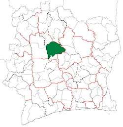 Location in Ivory Coast. Mankono Department has had these boundaries since 2012. | |
| Country |
|
| District | Woroba |
| Region | Béré |
| 1980 | Established as a first-level subdivision via a division of Séguéla Dept |
| 1997 | Converted to a second-level subdivision |
| 2005 | Divided to create Kounahiri Dept |
| 2011 | Converted to a third-level subdivision |
| 2012 | Divided to create Dianra Dept |
| Departmental seat | Mankono |
| Government[1] | |
| • Prefect | Dago Rémi Adjé |
| Population (2014) | |
| • Total | 215,500[2] |
| Time zone | GMT (UTC+0) |
Mankono Department is a department of Béré Region in Woroba District, Ivory Coast. In 2014, its population was 215,500 and its seat is the settlement of Mankono. The sub-prefectures of the department are Bouandougou, Mankono, Marandallah, Sarhala, and Tiéningboué.
History
.jpg)
.jpg)
Mankono Department was created in 1980 as a first-level subdivision via a split-off from Séguéla Department.[3] Using current boundaries as a reference, from 1980 to 2005 the department occupied the same territory as Béré Region.
In 1997, regions were introduced as new first-level subdivisions of Ivory Coast; as a result, all departments were converted into second-level subdivisions. Mankono Department was included in Worodougou Region.
In 2005, Mankono Department was divided to create Kounahiri Department.[3]
In 2011, districts were introduced as new first-level subdivisions of Ivory Coast. At the same time, regions were reorganised and became second-level subdivisions and all departments were converted into third-level subdivisions. At this time, Mankono Department became part of Béré Region in Woroba District.
In 2012, Mankono Department was divided again when two sub-prefectures were split-off to form Dianra Department.[4]
Notes
- ↑ "Préfets de Région et de Préfets de Département (Conseil des ministres du mercredi 26 septembre 2012)", abidjan.net, 2 October 2012.
- ↑ "Côte d'Ivoire". geohive.com. Retrieved 5 December 2015.
- 1 2 "Regions of Côte d'Ivoire (Ivory Coast)", statoids.com, accessed 16 February 2016.
- ↑ "Le décret n° 2012-611 du 04 juillet 2012 portant création des Départements de Djékanou, Sipilou, Kong, Gbéléban, Taabo, Kouassi-Kouassikro, Méagui, Séguélon, Buyo, M'Bengué, Facobly et Dianra".
Regional seat: Mankono | ||
| Dianra Department | 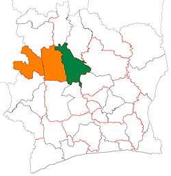 | |
| Kounahiri Department | ||
| Mankono Department | ||
* also a commune | ||
Coordinates: 8°4′N 6°11′W / 8.067°N 6.183°W