Marblehead Historic District
|
Marblehead Historic District | |
 | |
  | |
| Location | Marblehead, Massachusetts |
|---|---|
| Coordinates | 42°30′15″N 70°50′58″W / 42.50417°N 70.84944°WCoordinates: 42°30′15″N 70°50′58″W / 42.50417°N 70.84944°W |
| Built | 1670 |
| Architect | Multiple |
| Architectural style | Georgian, Other, Federal |
| NRHP Reference # | [1] |
| Added to NRHP | January 10, 1984 |
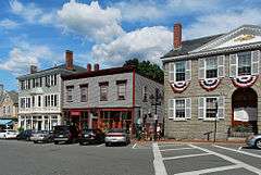
Marblehead Historic District is a historic district roughly bounded by Marblehead Harbor, Waldron Court, Essex, Elm, Pond, and Norman Streets in Marblehead, Massachusetts. Among its notable features are Fort Sewall, a coastal fortification with origins dating to 1644,[2] and two National Historic Landmarks, the General John Glover House,[3] and the Jeremiah Lee House.[4]
The district features Georgian, Federal and other styles of architecture. The area was added to the National Register of Historic Places in 1984.
See also
References
- ↑ National Park Service (2008-04-15). "National Register Information System". National Register of Historic Places. National Park Service.
- ↑ "MACRIS inventory record for Fort Sewall". Commonwealth of Massachusetts. Retrieved 2014-01-16.
- ↑ "MACRIS inventory record for General John Glover House". Commonwealth of Massachusetts. Retrieved 2014-01-16.
- ↑ "MACRIS inventory record for Jeremiah Lee Mansion". Commonwealth of Massachusetts. Retrieved 2014-01-17.
| |
| General Information | |
| Institutions | |
| Notable Residents |
|
| Historic Houses | |
| Historic Buildings and Sites | |
| Neighboring Towns | |
| |
| Topics |  | ||||||||||||||||||||||||||||||
|---|---|---|---|---|---|---|---|---|---|---|---|---|---|---|---|---|---|---|---|---|---|---|---|---|---|---|---|---|---|---|---|
| Lists by county | |||||||||||||||||||||||||||||||
| Lists by city |
| ||||||||||||||||||||||||||||||
| Other lists | |||||||||||||||||||||||||||||||
| |||||||||||||||||||||||||||||||
This article is issued from Wikipedia - version of the 11/27/2016. The text is available under the Creative Commons Attribution/Share Alike but additional terms may apply for the media files.