Maria Aurora, Aurora
| Maria Aurora | ||
|---|---|---|
| Municipality | ||
 | ||
| ||
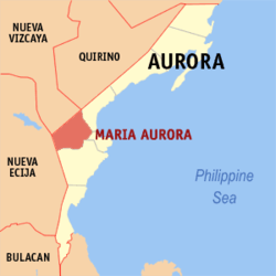 Location within Aurora province | ||
.svg.png) Maria Aurora Location within the Philippines | ||
| Coordinates: 15°47′N 121°28′E / 15.78°N 121.47°ECoordinates: 15°47′N 121°28′E / 15.78°N 121.47°E | ||
| Country | Philippines | |
| Region | Central Luzon (Region III) | |
| Province | Aurora | |
| District | Lone District | |
| Founded | July 21, 1949 | |
| Barangays | 40 (see Barangays) | |
| Government [1] | ||
| • Type | Sangguniang Bayan | |
| • Mayor | Amado M. Geneta | |
| Area[2] | ||
| • Total | 426.19 km2 (164.55 sq mi) | |
| Population (2015 census)[3] | ||
| • Total | 40,734 | |
| • Density | 96/km2 (250/sq mi) | |
| • Voter (2016)[4] | 23,341 | |
| Time zone | PST (UTC+8) | |
| ZIP code | 3202 | |
| IDD : area code | +63 (0)42 | |
| Income class | 2nd class | |
| PSGC | 037707000 | |
| Website |
www | |
Maria Aurora, officially the Municipality of Maria Aurora (Filipino: Bayan ng Maria Aurora), is a municipality in the province of Aurora in the Central Luzon (Region III) of the Philippines. The population was 40,734 at the 2015 census,[3] making it the most populous municipality in the province. In the 2016 election, it had 23,341 registered voters.[4]
The Millennium Tree in Balete Park and the lush green landscape is Maria Aurora's main tourist asset.
History
The town was named after Maria Aurora Aragon Quezon, the first daughter of Philippine President Manuel L. Quezon and First Lady Aurora Aragon Quezon. Maria Aurora along with her mother Aurora was ambushed by elements of the Hukbalahap movement in Nueva Ecija. The municipality of Maria Aurora was formed on July 21, 1949, through the Executive Order No. 249 out of various portions of the municipalities of Baler and Infanta, both of which were part of Quezon Province.[5]
Proposal for Dr. Juan C. Angara municipality
A separate municipality called Dr. Juan C. Angara is being proposed under Senate Bill No. 3132 and House Bill No. 6518.[6][7] The proposed municipality shall have a land area of 201.2 square kilometers and is composed of western barangays of Dianawan, Decoliat, Galintuja, San Juan, Suguit, Bazal, Pungio, Villa Aurora and Dialatnan. San Juan will serve as poblacion or the seat of government.
Geography
Maria Aurora is located at 15°47′N 121°28′E / 15.78°N 121.47°E.
According to the Philippine Statistics Authority, the municipality has a land area of 426.19 square kilometres (164.55 sq mi)[2] constituting 13.54% of the 3,147.32-square-kilometre- (1,215.19 sq mi) total area of Aurora.
Maria Aurora is the only non-coastal municipality of the province. It is bounded by Baler and Dipaculao on the east, San Luis on the south, the Province of Nueva Ecija on the west and the Province of Nueva Vizcaya on the north-west.
Barangays
Maria Aurora is politically subdivided into 40 barangays.[8]
| PSGC | Barangay | Population | ±% p.a. | ||
|---|---|---|---|---|---|
| 2015[3] | 2010[9] | ||||
| 037707001 | Alcala | 1.4% | 553 | 521 | +1.14% |
| 037707002 | Bagtu | 1.9% | 779 | 748 | +0.78% |
| 037707003 | Bangco | 1.7% | 676 | 636 | +1.17% |
| 037707004 | Bannawag | 1.2% | 496 | 492 | +0.15% |
| 037707005 | Barangay I (Poblacion) | 3.3% | 1,356 | 1,260 | +1.41% |
| 037707006 | Barangay II (Poblacion) | 4.7% | 1,930 | 1,874 | +0.56% |
| 037707007 | Barangay III (Poblacion) | 2.2% | 894 | 873 | +0.45% |
| 037707008 | Barangay IV (Poblacion) | 6.0% | 2,458 | 2,465 | −0.05% |
| 037707009 | Baubo | 1.6% | 642 | 634 | +0.24% |
| 037707010 | Bayanihan | 3.5% | 1,425 | 1,325 | +1.40% |
| 037707011 | Bazal | 3.4% | 1,368 | 1,274 | +1.36% |
| 037707012 | Cabituculan East | 1.7% | 676 | 664 | +0.34% |
| 037707013 | Cabituculan West | 1.3% | 534 | 493 | +1.53% |
| 037707027 | Cadayacan | 3.3% | 1,357 | 1,261 | +1.41% |
| 037707014 | Debucao | 3.4% | 1,385 | 1,293 | +1.32% |
| 037707015 | Decoliat | 1.2% | 472 | 457 | +0.62% |
| 037707016 | Detailen | 2.2% | 879 | 793 | +1.98% |
| 037707017 | Diaat | 3.8% | 1,528 | 1,460 | +0.87% |
| 037707018 | Dialatman | 0.5% | 198 | 183 | +1.51% |
| 037707019 | Diaman | 0.6% | 257 | 239 | +1.39% |
| 037707020 | Dianawan | 2.9% | 1,191 | 1,111 | +1.33% |
| 037707021 | Dikildit | 2.5% | 1,019 | 908 | +2.22% |
| 037707022 | Dimanpudso | 3.3% | 1,353 | 1,296 | +0.82% |
| 037707023 | Diome | 2.1% | 857 | 760 | +2.31% |
| 037707024 | Estonilo | 1.9% | 784 | 755 | +0.72% |
| 037707025 | Florida | 4.5% | 1,825 | 1,635 | +2.12% |
| 037707026 | Galintuja | 1.8% | 729 | 598 | +3.84% |
| 037707028 | Malasin | 1.6% | 654 | 593 | +1.88% |
| 037707029 | Ponglo | 1.1% | 466 | 543 | −2.87% |
| 037707030 | Quirino | 4.5% | 1,843 | 1,584 | +2.93% |
| 037707031 | Ramada | 2.9% | 1,172 | 1,134 | +0.63% |
| 037707032 | San Joaquin | 4.2% | 1,714 | 1,634 | +0.91% |
| 037707033 | San Jose | 4.1% | 1,677 | 1,460 | +2.67% |
| 037707040 | San Juan | 2.2% | 876 | 891 | −0.32% |
| 037707034 | San Leonardo | 1.1% | 455 | 475 | −0.82% |
| 037707035 | Santa Lucia | 1.4% | 578 | 541 | +1.27% |
| 037707036 | Santo Tomas | 1.7% | 697 | 684 | +0.36% |
| 037707037 | Suguit | 1.5% | 604 | 564 | +1.31% |
| 037707038 | Villa Aurora | 2.2% | 878 | 751 | +3.02% |
| 037707039 | Wenceslao | 3.7% | 1,499 | 1,266 | +3.27% |
| Total | 40,734 | 38,128 | +1.27% | ||
Demographics
| Population census of Maria Aurora | |||||||||||||||||||||||||
|---|---|---|---|---|---|---|---|---|---|---|---|---|---|---|---|---|---|---|---|---|---|---|---|---|---|
|
| ||||||||||||||||||||||||
| Source: PSA[3][9][10] | |||||||||||||||||||||||||
In the 2015 census, Maria Aurora had a population of 40,734.[3] The population density was 96 inhabitants per square kilometre (250/sq mi).
In the 2016 election, it had 23,341 registered voters.[4]
Government
Maria Aurora was administered by 12 mayors since its establishment in 1949.
- Mayor Pedro C. Montero (Jul 21, 1949 – Dec 31, 1951)
- Mayor Pedro S. Wenceslao (Jan 1, 1952 – Jun 21, 1958)
- Mayor Brigido E. Collado (Jun 22, 1958 – Dec 31, 1959)
- Mayor Leon B. Hulipas (Jan 1, 1960 – Dec 31, 1963)
- Mayor Leonardo T. Ong (Jan 1, 1964 – Aug 15, 1977)
- Mayor Juan R. Ortiz (Aug 16, 1977 – May 8, 1986)
- OJC Adriano C. Bitong (May 9, 1986 – Dec 1, 1987)
- OJC (LGO) Nepumuceno W. Gonzales (Dec 1, 1987 – Dec 15, 1987)
- Sec. Lorenzo O. Mangaoang (Dec. 16, 1987 – Feb 2, 1988)
- Mayor Adriano C. Bitong (Feb 3, 1988 – Jun 30, 1998)
- Mayor Brigido M. Noval (Jul 1, 1998 – Jun 30, 2004)
- Mayor Ariel S. Bitong (Jul 1, 2004 – Jun 30, 2013)
- Mayor Amado M. Geneta (Jul 1, 2013 – Present)
Transportation

Maria Aurora can be accessed by road through two routes: the Canili–Pantabangan Road, which passes Nueva Ecija's northern towns and through Alfonso Castañeda, Nueva Vizcaya; and the Nueva Ecija–Aurora Road, built on the 1940s that traverses the Sierra Madre Mountains and passes through the towns of Baler and San Luis. Today, the Canili–Pantabangan Road is much more commonly used, though it extends travel time for 1 hour, it is the safest route for vehicles. Originally, the Nueva Ecija–Aurora Road is the standard road for bus commuters, the shortest but the steep turns and unpaved roads makes it the most dangerous for heavy vehicles.
There are five bus lines that serve Maria Aurora's vicinity: Maria Aurora Express (PAPIN) (Cabanatuan–Dipaculao); D' Liner (Cabanatuan\Baguio - Maria Aurora, Casiguran; Genesis Bus Transport (Manila\Cabanatuan - Baler); - Aurora Bus Line (Cabanatuan - Baler) and Lizardo Transit (Baguio - Baler)
Health
The Department of Health sustains health over the municipality. The municipality has 21 health centers and one provincial hospital, the Aurora Provincial Hospital located in barangay Buhangin in Baler, 30 kilometers south of the town.
Education
Maria Aurora has its education sustained by the Department of Education - Division of Aurora. The municipality has 38 public elementary and high schools with 1 central school (Maria Aurora Central School). Private institutions in the municipality include the Wesleyan University - Philippines and Mount Carmel School of Maria Aurora.
Gallery
-

Municipal hall
-
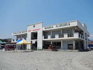
Public market
-
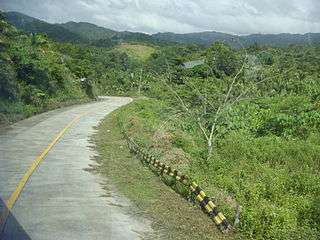
Highway, mountains and forests (Sitio Dimasalang, Brgy. Dimotol)
-
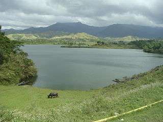
1970's Canili and Diayo Dams and Reservoirs (tributaries of Pantabangan Dam)
-
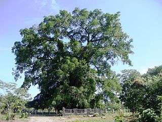
Millennium Tree at Balete Park
References
- ↑ "Municipality". Quezon City, Philippines: Department of the Interior and Local Government. Retrieved 31 May 2013.
- 1 2 "Province: Aurora". PSGC Interactive. Makati City, Philippines: Philippine Statistics Authority. Retrieved 6 November 2016.
- 1 2 3 4 5 "Region III (CENTRAL LUZON)". Census of Population (2015): Total Population by Province, City, Municipality and Barangay (Report). PSA. Retrieved 20 June 2016.
- 1 2 3 "2016 National and Local Elections Statistics". Commission on Elections. 2016.
- ↑ "Executive Order No. 246; Organizing Certain Portions of the Municipalities of Baler and Infanta, Quezon Province, into Independent Municipalities, Under the Names of Maria Aurora and General Nakar, Respectively" (PDF). Official Gazette of the Republic of the Philippines. Malacañan Palace, Manila, Philippines. 21 July 1949. Archived from the original (PDF) on 14 October 2016. Retrieved 6 November 2016.
- ↑ "Fifteenth Congress; Senate Bill No. 3132; An Act Creating the Municipality of Dr. Juan C. Angara in the Province of Aurora" (PDF). Senate of the Philippines. 23 February 2012. Archived from the original (PDF) on 4 March 2016. Retrieved 6 November 2016.
- ↑ "H. No. 6518; An Act Creating the Municipality of Dr. Juan C. Angara in the Province of Aurora" (PDF). Archived from the original (PDF) on 3 September 2014. Retrieved 6 November 2016.
- ↑ "Municipal: Maria Aurora, Aurora". PSA. Philippines: National Statistical Coordination Board. Retrieved 8 January 2016.
- 1 2 "Region III (CENTRAL LUZON)". Census of Population and Housing (2010): Total Population by Province, City, Municipality and Barangay (Report). NSO. Retrieved 29 June 2016.
- ↑ "Region III (CENTRAL LUZON)". Census of Population (1995, 2000 and 2007): Total Population by Province, City and Municipality (Report). NSO. Archived from the original on 24 June 2011.
- ↑ "DAR Turns-Over P317m-Bridge Project in Aurora Province". Department of Agrarian Reform. Elliptical Road, Diliman Quezon City, Philippines. 14 June 2011. Archived from the original on 19 April 2012. Retrieved 6 November 2016.
External links
| Wikimedia Commons has media related to Maria Aurora, Aurora. |
 |
Alfonso Castañeda, Nueva Vizcaya | Dipaculao | | |
| Pantabangan, Nueva Ecija | |
Baler | ||
| ||||
| | ||||
| Bongabon, Nueva Ecija | San Luis |
Baler (capital) | |
| Municipalities | |
| Barangays | |