Martinsburg, Iowa
| Martinsburg, Iowa | |
|---|---|
| City | |
|
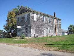
Abandoned Mason's lodge in Martinsburg | |
 Location of Martinsburg, Iowa | |
| Coordinates: 41°10′42″N 92°15′5″W / 41.17833°N 92.25139°WCoordinates: 41°10′42″N 92°15′5″W / 41.17833°N 92.25139°W | |
| Country |
|
| State |
|
| County | Keokuk |
| Area[1] | |
| • Total | 0.38 sq mi (0.98 km2) |
| • Land | 0.38 sq mi (0.98 km2) |
| • Water | 0 sq mi (0 km2) |
| Elevation | 804 ft (245 m) |
| Population (2010)[2] | |
| • Total | 112 |
| • Estimate (2012[3]) | 111 |
| • Density | 294.7/sq mi (113.8/km2) |
| Time zone | Central (CST) (UTC-6) |
| • Summer (DST) | CDT (UTC-5) |
| ZIP code | 52568 |
| Area code(s) | 319 |
| FIPS code | 19-49935 |
| GNIS feature ID | 0458833 |
Martinsburg is a city in Keokuk County, Iowa, United States. The population was 112 at the 2010 census. The only businesses open to the public in Martinsburg is McBeth Wrecker and Auto Service and a gas station/convenience store.
Geography
Martinsburg is located at 41°10′42″N 92°15′5″W / 41.17833°N 92.25139°W (41.178350, -92.251326).[4]
According to the United States Census Bureau, the city has a total area of 0.38 square miles (0.98 km2), all of it land.[1]
Demographics
| Historical populations | ||
|---|---|---|
| Year | Pop. | ±% |
| 1880 | 154 | — |
| 1890 | 322 | +109.1% |
| 1900 | 332 | +3.1% |
| 1910 | 285 | −14.2% |
| 1920 | 278 | −2.5% |
| 1930 | 223 | −19.8% |
| 1940 | 218 | −2.2% |
| 1950 | 219 | +0.5% |
| 1960 | 172 | −21.5% |
| 1970 | 140 | −18.6% |
| 1980 | 174 | +24.3% |
| 1990 | 157 | −9.8% |
| 2000 | 126 | −19.7% |
| 2010 | 112 | −11.1% |
| 2014 | 110 | −1.8% |
| 2015 | 110 | +0.0% |
| Source:"American FactFinder". United States Census Bureau. and Iowa Data Center Source: | ||
2010 census
As of the census[2] of 2010, there were 112 people, 47 households, and 32 families residing in the city. The population density was 294.7 inhabitants per square mile (113.8/km2). There were 55 housing units at an average density of 144.7 per square mile (55.9/km2). The racial makeup of the city was 99.1% White and 0.9% African American.
There were 47 households of which 34.0% had children under the age of 18 living with them, 48.9% were married couples living together, 10.6% had a female householder with no husband present, 8.5% had a male householder with no wife present, and 31.9% were non-families. 29.8% of all households were made up of individuals and 10.7% had someone living alone who was 65 years of age or older. The average household size was 2.38 and the average family size was 2.84.
The median age in the city was 41.8 years. 24.1% of residents were under the age of 18; 6.4% were between the ages of 18 and 24; 27.7% were from 25 to 44; 28.6% were from 45 to 64; and 13.4% were 65 years of age or older. The gender makeup of the city was 50.9% male and 49.1% female.
2000 census
As of the census[6] of 2000, there were 126 people, 51 households, and 39 families residing in the city. The population density was 333.4 people per square mile (128.0/km²). There were 60 housing units at an average density of 158.8 per square mile (61.0/km²). The racial makeup of the city was 97.62% White and 2.38% Native American.
There were 51 households out of which 27.5% had children under the age of 18 living with them, 60.8% were married couples living together, 13.7% had a female householder with no husband present, and 23.5% were non-families. 19.6% of all households were made up of individuals and 9.8% had someone living alone who was 65 years of age or older. The average household size was 2.47 and the average family size was 2.82.
In the city the population was spread out with 23.8% under the age of 18, 8.7% from 18 to 24, 23.0% from 25 to 44, 24.6% from 45 to 64, and 19.8% who were 65 years of age or older. The median age was 42 years. For every 100 females there were 93.8 males. For every 100 females age 18 and over, there were 88.2 males.
The median income for a household in the city was $35,625, and the median income for a family was $41,250. Males had a median income of $26,250 versus $13,750 for females. The per capita income for the city was $17,807. There were no families and 1.6% of the population living below the poverty line, including no under eighteens and 8.0% of those over 64.
Notable people
- Gayno Smith, mass murderer
References
- 1 2 "US Gazetteer files 2010". United States Census Bureau. Archived from the original on January 24, 2012. Retrieved 2012-05-11.
- 1 2 "American FactFinder". United States Census Bureau. Retrieved 2012-05-11.
- ↑ "Population Estimates". United States Census Bureau. Archived from the original on June 17, 2013. Retrieved 2013-05-23.
- ↑ "US Gazetteer files: 2010, 2000, and 1990". United States Census Bureau. 2011-02-12. Retrieved 2011-04-23.
- ↑ "Census of Population and Housing". Census.gov. Archived from the original on May 11, 2015. Retrieved June 4, 2015.
- ↑ "American FactFinder". United States Census Bureau. Retrieved 2008-01-31.
Municipalities and communities of Keokuk County, Iowa, United States | ||
|---|---|---|
| Cities | ||
| Unincorporated communities | ||
| Footnotes | ‡This populated place also has portions in an adjacent county or counties | |