Maryland Route 304
| ||||
|---|---|---|---|---|
|
Maryland Route 304 highlighted in red | ||||
| Route information | ||||
| Maintained by MDSHA and Town of Centreville | ||||
| Length: | 15.23 mi[1] (24.51 km) | |||
| Existed: | 1927 – present | |||
| Major junctions | ||||
| West end: | Spider Web Road near Centreville | |||
|
| ||||
| East end: |
| |||
| Location | ||||
| Counties: | Queen Anne's, Caroline | |||
| Highway system | ||||
| ||||

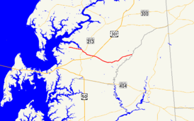
Maryland Route 304 (MD 304) is a state highway in the U.S. state of Maryland. The state highway runs 15.23 miles (24.51 km) from Spider Web Road near Centreville east to MD 312 in Bridgetown. MD 304 connects Centreville with U.S. Route 301 (US 301) and several small settlements in central Queen Anne's County and northern Caroline County, including Ruthsburg and Bridgetown. The state highway is officially split into two sections, MD 304 and MD 304A, separated by a superstreet intersection with US 301. MD 304 originally consisted of its present streets in Centreville and a short piece of road to the east. The state highway was gradually extended eastward across central Queen Anne's County in the late 1930s and 1940s, reaching Ruthsburg in 1948. West of Centreville, MD 304 took over MD 606 in 1951 to achieve its present western terminus. The state highway was extended east to Bridgetown in the mid-1960s, taking over part of MD 405. Maintenance of the streets in Centreville was returned to the town in the 1960s.
Route description
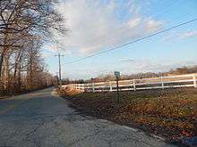
MD 304 begins at the intersection of Corsica Neck Road and Spider Web Road on the Corsica Neck peninsula west of Centreville. The state highway heads east as two-lane Corsica Neck Road through a mix of farmland and forest. MD 304 crosses Earl Creek then crosses the Corsica River to enter the town of Centreville, where the highway is municipally-maintained and passes through the Centreville Historic District. The highway's name changes to Chesterfield Avenue and it passes through a residential area with scattered county offices. In the downtown area one block south of the Queen Anne's County Courthouse, MD 304 meets MD 213, which follows a one-way pair through the town, Liberty Street southbound and Commerce Street northbound. MD 304 continues east as Water Street, crossing the Centreville Branch of the Northern Line of the Maryland and Delaware Railroad. At Tilghman Street, the highway's name changes to Railroad Avenue. MD 304 leaves Centreville just east of Kidwell Avenue.[1][2]
MD 304 continues east through farmland as Ruthsburg Road, passing Queen Anne's County High School and Centreville Middle School before reaching the intersection with US 301 (Blue Star Memorial Highway). The intersection with US 301 is a superstreet intersection in which MD 304 traffic must turn right, use U-turn ramps along US 301, and turn right again to continue on MD 304. The state highway officially continues as MD 304A and intersects MD 481 (Damsontown Road) in the hamlet of Ruthsburg. MD 304 heads northeast and crosses German Branch before intersecting MD 405 (Price Station Road). Shortly after the highway enters Caroline County by crossing Mason Branch, the highway, now named Bridgetown Road, reaches its eastern terminus at MD 312 (Oakland Road) in the village of Bridgetown. Bridgetown Road continues east as a county highway toward Goldsboro.[1][2]
History
| |
|---|---|
| Location: | Centreville |
| Existed: | 1935–1951 |
The first section of present-day MD 304 to be paved was the Bridgetown Road segment, which was built as a state aid road by 1915.[3] Water Street, Railroad Avenue, and Ruthsburg Road east to Rolling Bridge Road were paved as a state aid road by 1921.[4] Chesterfield Avenue was paved as a state road in 1924 and 1925.[5][6] Corsica Neck Road and a new bridge across the Corsica River were completed in 1935, and designated MD 606.[7][8][9] MD 304 was extended to a point just east of present-day US 301 in 1938.[10][11] The state highway was extended to Greenville Road in 1942 and to MD 481 in Ruthsburg in 1948.[12][13][14][15]
Current MD 304 near Bridgetown was constructed as part of MD 405 and completed in 1942 to Bridgetown.[12][13] In 1951, MD 304 was extended west over MD 606 to its present western terminus.[16] MD 304 was extended east of MD 481 and assumed MD 405's route into Bridgetown to its present eastern terminus in 1964.[17] Chesterfield Avenue was returned to the town of Centreville to maintain by 1961; Water Street and Railroad Avenue were transferred in 1968.[18][19] MD 304A was designated along the portion of MD 304 east of US 301 when the superstreet intersection between the two highways was installed in 2011.[20]
Future
The Maryland Department of Transportation is building a dumbbell interchange to replace the superstreet intersection with US 301.[21][22] The interchange project will construct a bridge carrying MD 304 over US 301. This proposed interchange was the top transportation priority for Queen Anne's County for years and was pushed for by students at Queen Anne's County High School after a student at the school was killed in an accident at the intersection in 2010. A groundbreaking ceremony was held on September 23, 2014, with several Queen Anne's County commissioners and representatives from state government in attendance.[22] Construction is expected to be completed in 2017.[21]
Junction list
| County | Location | mi [1] | km | Destinations | Notes |
|---|---|---|---|---|---|
| Queen Anne's | | 0.00 | 0.00 | Corsica Neck Road west / Spider Web Road south | Western terminus of MD 304 |
| Centreville | 3.21 | 5.17 | |||
| 3.28 | 5.28 | ||||
| | 5.79 | 9.32 | Superstreet intersection; Interchange under construction; eastern terminus of MD 304; western terminus of MD 304A | ||
| Ruthsburg | 9.99 | 16.08 | |||
| | 13.85 | 22.29 | |||
| Caroline | Bridgetown | 15.23 | 24.51 | Eastern terminus of MD 304A | |
| 1.000 mi = 1.609 km; 1.000 km = 0.621 mi | |||||
See also
 Maryland Roads portal
References
- 1 2 3 4 Highway Information Services Division (December 31, 2013). Highway Location Reference. Maryland State Highway Administration. Retrieved 2012-06-23.
- Queen Anne's County (PDF)
- Caroline County (PDF)
- 1 2 Google (2010-09-28). "Maryland Route 304" (Map). Google Maps. Google. Retrieved 2010-09-28.
- ↑ Weller, O.E.; Parran, Thomas; Miller, W.B.; Perry, John M.; Ramsay, Andrew; Smith, J. Frank (May 1916). Annual Reports of the State Roads Commission of Maryland (1912–1915 ed.). Baltimore: Maryland State Roads Commission. pp. 122, 128. Retrieved 2010-09-28.
- ↑ Maryland Geological Survey (1921). Map of Maryland: Showing State Road System and State Aid Roads (Map). Baltimore: Maryland Geological Survey.
- ↑ Mackall, John N.; Darnall, R. Bennett; Brown, W.W. (January 1927). Annual Reports of the State Roads Commission of Maryland (1924–1926 ed.). Baltimore: Maryland State Roads Commission. pp. 33, 95. Retrieved 2010-09-28.
- ↑ Maryland Geological Survey (1927). Map of Maryland: Showing State Road System and State Aid Roads (Map). Baltimore: Maryland Geological Survey.
- ↑ Byron, William D.; Lacy, Robert (December 28, 1934). Report of the State Roads Commission of Maryland (1931–1934 ed.). Baltimore: Maryland State Roads Commission. p. 351. Retrieved 2010-09-28.
- ↑ Maryland Geological Survey (1935). Map of Maryland Showing State Road System: State Aid Roads and Improved County Road Connections (Map). Baltimore: Maryland Geological Survey.
- ↑ Maryland State Roads Commission (1939). General Highway Map: State of Maryland (Map). Baltimore: Maryland State Roads Commission.
- ↑ Beall, J. Glenn; Jarboe, Elmer R.; Obrecht, George F., Sr. (March 4, 1939). Report of the State Roads Commission of Maryland (1937–1938 ed.). Baltimore: Maryland State Roads Commission. p. 105. Retrieved 2010-09-28.
- ↑ Maryland State Roads Commission (1938). Map of Maryland Showing State Road System (Map). Baltimore: Maryland State Roads Commission.
- 1 2 Whitman, Ezra B.; Webb, P. Watson; Thomas, W. Frank (March 15, 1943). Report of the State Roads Commission of Maryland (1941–1942 ed.). Baltimore: Maryland State Roads Commission. p. 81. Retrieved 2010-09-28.
- 1 2 Maryland State Roads Commission (1946). Maryland: Official Highway Map (Map) (1946–47 ed.). Baltimore: Maryland State Roads Commission.
- ↑ Reindollar, Robert M.; George, Joseph M.; McCain, Russell H. (February 15, 1949). Report of the State Roads Commission of Maryland (1947–1948 ed.). Baltimore: Maryland State Roads Commission. p. 106. Retrieved 2010-09-28.
- ↑ Maryland State Roads Commission (1950). Maryland: Official Highway Map (Map). Baltimore: Maryland State Roads Commission.
- ↑ Maryland State Roads Commission (1951). Maryland: Official Highway Map (Map). Baltimore: Maryland State Roads Commission.
- ↑ Maryland State Roads Commission (1964). Maryland: Official Highway Map (Map). Baltimore: Maryland State Roads Commission.
- ↑ Maryland State Roads Commission (1961). Maryland: Official Highway Map (Map). Baltimore: Maryland State Roads Commission.
- ↑ Maryland State Roads Commission (1968). Maryland: Official Highway Map (Map). Baltimore: Maryland State Roads Commission.
- ↑ Highway Information Services Division (December 31, 2011). Highway Location Reference. Maryland State Highway Administration. Retrieved 2012-06-23.
- Queen Anne's County (PDF)
- Caroline County (PDF)
- 1 2 "US 301 / MD 304 Interchange Construction" (PDF). Maryland Department of Transportation. Retrieved February 11, 2016.
- 1 2 Wolf, Alex (September 26, 2014). "Ground broken for 301/304 overpass". Kent Island Bay Times. Retrieved February 11, 2016.
External links
| Wikimedia Commons has media related to Maryland Route 304. |