Caroline County, Maryland
| Caroline County, Maryland | |||
|---|---|---|---|
| County | |||
| Caroline County | |||
|
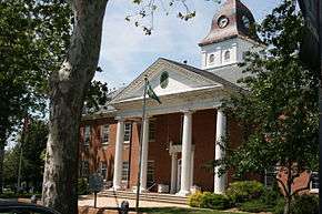
The Caroline County Courthouse in July 2012 | |||
| |||
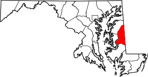 Location in the U.S. state of Maryland | |||
 Maryland's location in the U.S. | |||
| Founded | 1774 | ||
| Named for | Caroline Eden | ||
| Seat | Denton | ||
| Largest town | Denton | ||
| Area | |||
| • Total | 326 sq mi (844 km2) | ||
| • Land | 319 sq mi (826 km2) | ||
| • Water | 6.5 sq mi (17 km2), 2.0% | ||
| Population (est.) | |||
| • (2015) | 32,579 | ||
| • Density | 99/sq mi (38/km²) | ||
| Congressional district | 1st | ||
| Time zone | Eastern: UTC-5/-4 | ||
| Website |
www | ||
Coordinates: 38°52′N 75°49′W / 38.867°N 75.817°W
Caroline County is a rural county located in the U.S. state of Maryland on its Eastern Shore. As of the 2010 census, the population was 33,066.[1] Its county seat is Denton.[2][3]
Caroline County is bordered by Queen Anne's County to the north, Talbot County to the west, Dorchester County to the south, Kent County, Delaware, to the east, and Sussex County, Delaware, to the southeast.[4]
History
Caroline County was created in 1774[5] from parts of Dorchester and Queen Anne's counties. The county derives its name from Lady Caroline Eden, wife of Maryland's last colonial governor, Robert Eden.[6] At the time of its creation, seven commissioners were appointed: Charles Dickinson, Benson Stainton, Thomas White, William Haskins, Richard Mason, Joshua Clark, and Nathaniel Potter. These men bought 4 acres (1.6 ha) of land at Pig Point (now Denton) on which to build a courthouse and jail.[7]
Until the completion of these buildings, court was held at Melvill's Warehouse, approximately 1.5 miles (2.4 km) above Pig Point. Elections and other business transactions were completed there, and the town became the center of the county. The first court session was held on March 15, 1774, at Melvill's Warehouse. In 1777, court was moved to Bridgetown (now Greensboro), but in the interest of convenience, court was moved back to Melvill's.[7]
Disagreements arose concerning the permanent location of the county seat. The General Assembly reached a compromise in 1785 and ordered that 2 acres (0.81 ha) of land at Melvill's Landing should be purchased for a courthouse and jail. In 1790, the county court and its belongings moved to Pig Point. The Caroline County Courthouse was completed in 1797.[7]
The county has a number of properties on the National Register of Historic Places.[8] The National Park Service is developing a site in the southern half of Caroline County dedicated to interpreting the Underground Railroad as part of the Harriet Tubman Underground Railroad National Monument.
Government
Caroline County was granted home rule in 1984 under state code in an initiative led by County Commissioner Charles T. Dean, Sr.[9]
- The current County Commissioners as of 2016 are:[9]
- Larry C. Porter - Republican
- Wilbur Levengood, Jr. - Republican
- Daniel J. Franklin - Republican
- County Administrator: Ken Decker[9]
- Executive Assistant to the County Commissioners: Sara Visintainer[9]
Growth is a major issue faced by Caroline County and several other Mid-Shore counties. Retirees and workers willing to commute across the Chesapeake Bay to the western shore are increasingly attracted by the rural environment and low cost of living.
From 1994 to 2014 Caroline was the only county in the state not represented by a resident legislator in the Maryland General Assembly. Redistricting and a sparse population were the chief causes.
Politics
The county is divided almost evenly between Democrats and Republicans. As of 2010, there are 54 fewer Democrats than Republicans in the county.[10] There are approximately 18,000 registered voters in the county.[10]
In the 2010 midterm elections, there were a total of 18,037 eligible voters in Caroline County.[10] 7,461 were affiliated with the Republican Party,[10] 7,407 with the Democratic Party,[10] 59 with the Libertarian Party,[10] 36 with the Green Party,[10] 5 with the Constitution Party,[10] 2,949 were unaffiliated,[10] and 120 were affiliated with another party.[10]
| Party | Eligible voters | % | |
|---|---|---|---|
| Republican | 7,461 | 41.36% | |
| Democratic | 7,407 | 41.07% | |
| Libertarian Party | 59 | 0.33% | |
| Green Party | 36 | 0.2% | |
| Constitution Party | 5 | 0.03% | |
| Unaffiliated | 2,949 | 16.35% | |
| Other | 120 | 0.67% |
Geography
According to the U.S. Census Bureau, the county has a total area of 326 square miles (840 km2), of which 319 square miles (830 km2) is land and 6.5 square miles (17 km2) (2.0%) is water.[11] It is the second-smallest county by total area in Maryland. Notable waterways include the Choptank River and Tuckahoe Creek, as well as the man-made Williston Lake.
Caroline County currently ranks seventh nationally in terms of land protected under the Ag Preservation Program.
Its eastern border is the Mason–Dixon line.
Caroline is the only Eastern Shore county not to touch either the Chesapeake Bay or Atlantic Ocean. Additionally, it is the only county on the Eastern Shore without an Interstate or United States Highway within its borders.
Tuckahoe State Park, Holiday Park Campgrounds and Martinak State Park are located in Caroline County.
Adjacent counties
- Kent County, Delaware (northeast)
- Sussex County, Delaware (southeast)
- Dorchester County (south)
- Talbot County (west)
- Queen Anne's County (northwest)
Demographics
| Historical population | |||
|---|---|---|---|
| Census | Pop. | %± | |
| 1790 | 9,506 | — | |
| 1800 | 9,226 | −2.9% | |
| 1810 | 9,453 | 2.5% | |
| 1820 | 10,108 | 6.9% | |
| 1830 | 9,070 | −10.3% | |
| 1840 | 7,806 | −13.9% | |
| 1850 | 9,692 | 24.2% | |
| 1860 | 11,129 | 14.8% | |
| 1870 | 12,101 | 8.7% | |
| 1880 | 13,766 | 13.8% | |
| 1890 | 13,903 | 1.0% | |
| 1900 | 16,248 | 16.9% | |
| 1910 | 19,216 | 18.3% | |
| 1920 | 18,652 | −2.9% | |
| 1930 | 17,387 | −6.8% | |
| 1940 | 17,549 | 0.9% | |
| 1950 | 18,234 | 3.9% | |
| 1960 | 19,462 | 6.7% | |
| 1970 | 19,781 | 1.6% | |
| 1980 | 23,143 | 17.0% | |
| 1990 | 27,035 | 16.8% | |
| 2000 | 29,772 | 10.1% | |
| 2010 | 33,066 | 11.1% | |
| Est. 2015 | 32,579 | [12] | −1.5% |
| U.S. Decennial Census[13] 1790-1960[14] 1900-1990[15] 1990-2000[16] 2010-2015[1] | |||
2000 census
As of the census[17] of 2000, there were 29,772 people, 11,097 households, and 8,156 families residing in the county. The population density was 93 people per square mile (36/km²). There were 12,028 housing units at an average density of 38 per square mile (15/km²). The racial makeup of the county was 81.69% White, 14.77% Black or African American, 0.37% Native American, 0.55% Asian, 0.02% Pacific Islander, 1.26% from other races, and 1.34% from two or more races. 2.65% of the population were Hispanic or Latino of any race. 17.4% were of United States or American, 14.8% English, 14.4% German and 9.9% Irish ancestry.
There were 11,097 households out of which 34.80% had children under the age of 18 living with them, 54.30% were married couples living together, 13.60% had a female householder with no husband present, and 26.50% were non-families. 21.50% of all households were made up of individuals and 9.40% had someone living alone who was 65 years of age or older. The average household size was 2.64 and the average family size was 3.03.
In the county the population was spread out with 26.80% under the age of 18, 7.70% from 18 to 24, 28.90% from 25 to 44, 23.10% from 45 to 64, and 13.50% who were 65 years of age or older. The median age was 37 years. For every 100 females there were 95.90 males. For every 100 females age 18 and over, there were 91.70 males.
The median income for a household in the county was $38,832, and the median income for a family was $44,825. Males had a median income of $31,119 versus $21,915 for females. The per capita income for the county was $17,275. About 9.00% of families and 11.70% of the population were below the poverty line, including 14.50% of those under age 18 and 12.30% of those age 65 or over. It is regularly ranked among the poorest of all 23 Maryland counties.
As of Census 2010 the racial makeup of Caroline County was 78.19% Non-Hispanic white, 13.87% black, 0.37% Native American, 0.57% Asian, 0.16% Pacific Islander, 0.10% Non-Hispanics of some other race, 1.68% Non-Hispanics of two or more races and 5.49% Hispanic or Latino.
2010 census
As of the 2010 United States Census, there were 33,066 people, 12,158 households, and 8,702 families residing in the county.[18] The population density was 103.5 inhabitants per square mile (40.0/km2). There were 13,482 housing units at an average density of 42.2 per square mile (16.3/km2).[19] The racial makeup of the county was 79.8% white, 13.9% black or African American, 0.6% Asian, 0.4% American Indian, 0.2% Pacific islander, 3.1% from other races, and 2.1% from two or more races. Those of Hispanic or Latino origin made up 5.5% of the population.[18] In terms of ancestry, 21.7% were German, 15.6% were Irish, 12.3% were English, and 6.9% were American.[20]
Of the 12,158 households, 36.3% had children under the age of 18 living with them, 52.1% were married couples living together, 13.6% had a female householder with no husband present, 28.4% were non-families, and 22.7% of all households were made up of individuals. The average household size was 2.68 and the average family size was 3.12. The median age was 38.7 years.[18]
The median income for a household in the county was $58,799 and the median income for a family was $65,801. Males had a median income of $45,944 versus $33,927 for females. The per capita income for the county was $24,294. About 8.0% of families and 11.5% of the population were below the poverty line, including 15.5% of those under age 18 and 11.1% of those age 65 or over.[21]
Education
- North Caroline High School
- Colonel Richardson High School
- Caroline Career & Technology Center
- Lockerman Middle School
- Colonel Richardson Middle School
- Denton Elementary School
- Federalsburg Elementary School
- Greensboro Elementary School
- Preston Elementary School
- Ridgely Elementary School
- Wesleyan Christian School- no longer opened
Media
The local newspaper is The Times-Record. A second local publication, the Caroline Review, circulates monthly and is free of charge.
Entertainment
- The citizens of the towns of Hickman & Preston were once recognized by the TV show Hee Haw. In fact, the Hickman segment is the episode featured in the comedy wing of the Country Music Hall of Fame.
- Baseball Hall of Famer Jimmie Foxx began his career as a semipro catcher in Ridgely. Another Hall of Famer, Home Run Baker, played for the town team as well.
- Rocker George Thorogood played Caroline County bars while attending the University of Delaware before hitting the big time.
- The 2004 South Caroline baseball team made it to the Little League World Series in Williamsport, Pennsylvania, and placed third in the nation.
- Summerfest is held each August in Denton.
- The Caroline County Fair is held each August in Williston.
- The Strawberry Festival is held every Memorial Day weekend in Ridgely, Maryland.
Transportation
Caroline County is one of three Maryland counties that does not have an Interstate or U.S. Highway running through it. Caroline's "major artery" is Maryland Route 404, four lanes in some parts but two lanes in others. It is chiefly used in the summertime by non-local beachgoers heading to Ocean City, Maryland, or Rehoboth Beach, Delaware.
 Maryland Route 16
 Maryland Route 287
 Maryland Route 302
 Maryland Route 304
 Maryland Route 306
 Maryland Route 307
 Maryland Route 308
 Maryland Route 311
 Maryland Route 312
 Maryland Route 313
 Maryland Route 314
 Maryland Route 315
 Maryland Route 317
 Maryland Route 328
 Maryland Route 331
 Maryland Route 404
 Maryland Route 454
 Maryland Route 480
Communities
Towns
- Denton (county seat)
- Federalsburg
- Goldsboro
- Greensboro
- Henderson
- Hillsboro
- Marydel
- Preston
- Ridgely
- Templeville (partly in Queen Anne's County)
Census-designated places
The United States Census Bureau recognizes three Census-designated places in Caroline County:
Unincorporated communities
Notable residents
- Patty Cannon, slave kidnapper, operated out of the county, owning a house in Reliance.
- Charles Dickinson, killed in a duel in 1806 by future President Andrew Jackson
- Frederick Douglass, orator, social reformer, former slave
- Thomas Alan Goldsborough, noted jurist and congressman
- Harry R. Hughes, Governor of Maryland, 1979-1987
- Sophie Kerr, early 20th century author and benefactor of the largest undergraduate literary prize in the nation, at Washington College in Chestertown
- William Richardson, hero of the Battle of Harlem Heights in the Revolutionary War
- Liam Guida, adventurer
- Thomas Alexander Smith, early 20th century congressman and businessman
- Sherman W. Tribbitt, Governor of Delaware, 1973-1977
- Harriet Tubman, abolitionist, humanitarian, former slave
- Andrew "Mantooth" Dhue, elected county tour guide
- George A. Waggaman, US senator from Louisiana
See also
- National Register of Historic Places listings in Caroline County, Maryland
- USS Caroline County (LST-525)
References
- 1 2 "State & County QuickFacts". United States Census Bureau. Retrieved August 24, 2013.
- ↑ Caroline County Government - Office of the County Commissioners
- ↑ "Find a County". National Association of Counties. Archived from the original on 2011-05-31. Retrieved 2011-06-07.
- ↑ Map of Denton, MD by MapQuest
- ↑ Noble, Edward. "The History of Caroline County". Regional Publishing Company, 1971, p.1.
- ↑ Maryland, Caroline County "She's waiting for you"
- 1 2 3 Formation of Caroline County
- ↑ National Park Service (2008-04-15). "National Register Information System". National Register of Historic Places. National Park Service.
- 1 2 3 4 "The County Data of Caroline County".
- 1 2 3 4 5 6 7 8 9 10 "2010 Gubernatorial General Election - Voter Turnout | By Party and County". Maryland State Board of Elections.
- ↑ "2010 Census Gazetteer Files". United States Census Bureau. August 22, 2012. Retrieved September 12, 2014.
- ↑ "County Totals Dataset: Population, Population Change and Estimated Components of Population Change: April 1, 2010 to July 1, 2015". Retrieved July 2, 2016.
- ↑ "U.S. Decennial Census". United States Census Bureau. Archived from the original on May 11, 2015. Retrieved September 12, 2014.
- ↑ "Historical Census Browser". University of Virginia Library. Retrieved September 12, 2014.
- ↑ "Population of Counties by Decennial Census: 1900 to 1990". United States Census Bureau. Retrieved September 12, 2014.
- ↑ "Census 2000 PHC-T-4. Ranking Tables for Counties: 1990 and 2000" (PDF). United States Census Bureau. Retrieved September 12, 2014.
- ↑ "American FactFinder". United States Census Bureau. Archived from the original on 2013-09-11. Retrieved 2008-01-31.
- 1 2 3 "DP-1 Profile of General Population and Housing Characteristics: 2010 Demographic Profile Data". United States Census Bureau. Retrieved 2016-01-22.
- ↑ "Population, Housing Units, Area, and Density: 2010 - County". United States Census Bureau. Retrieved 2016-01-22.
- ↑ "DP02 SELECTED SOCIAL CHARACTERISTICS IN THE UNITED STATES – 2006-2010 American Community Survey 5-Year Estimates". United States Census Bureau. Retrieved 2016-01-22.
- ↑ "DP03 SELECTED ECONOMIC CHARACTERISTICS – 2006-2010 American Community Survey 5-Year Estimates". United States Census Bureau. Retrieved 2016-01-22.
External links
- Official website
- Caroline County Fair
- Times-Record, county newspaper
 Geographic data related to Caroline County, Maryland at OpenStreetMap
 |
Queen Anne's County | Kent County, Delaware | | |
| Talbot County | |
|||
| ||||
| | ||||
| Dorchester County | Sussex County, Delaware |
Municipalities and communities of Caroline County, Maryland, United States | ||
|---|---|---|
| Towns | | |
| CDPs | ||
| Unincorporated communities | ||
| Footnotes | ‡This populated place also has portions in an adjacent county or counties | |