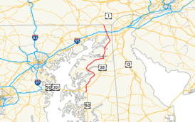
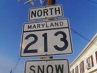
Maryland Route 213
| |||||||
|---|---|---|---|---|---|---|---|
 | |||||||
| Route information | |||||||
| Maintained by MDSHA and USACE | |||||||
| Length: | 68.25 mi[1] (109.84 km) | ||||||
| Existed: | 1971 – present | ||||||
| Tourist routes: |
| ||||||
| Major junctions | |||||||
| South end: |
| ||||||
|
| |||||||
| North end: |
| ||||||
| Location | |||||||
| Counties: | Queen Anne's, Kent, Cecil | ||||||
| Highway system | |||||||
| |||||||

Maryland Route 213 (MD 213) is a 68.25-mile (109.84 km) state highway located on the Eastern Shore of Maryland in the United States. The route runs from MD 662 in Wye Mills, Queen Anne's County north to the Pennsylvania border in Cecil County, where it continues into that state as Pennsylvania Route 841 (PA 841). The route, which is a two-lane undivided highway its entire length, passes through mostly rural areas as well as the communities of Centreville, Chestertown, Galena, Cecilton, Chesapeake City, and Elkton. MD 213 intersects many routes including U.S. Route 50 (US 50) near Wye Mills, US 301 near Centreville, and US 40 in Elkton. It crosses over the Chesapeake and Delaware Canal in Chesapeake City on the Chesapeake City Bridge. MD 213 is designated by the state as the Chesapeake Country Scenic Byway between the southern terminus and Chesapeake City with the portion north of MD 18 in Centreville a National Scenic Byway. In addition, the route is also considered part of the Atlantic to Appalachians Scenic Byway between Chesapeake City and MD 273 in Fair Hill.
The route was initially designated as US 213 in 1926 when the U.S. Highway System was established, running from Ocean City west and north to US 40 in Elkton. The highway was rerouted to cross the Nanticoke River in Vienna by 1933, with the former route between Mardela Springs and Eldorado becoming a part of MD 313 and the alignment between Eldorado and Rhodesdale becoming part of MD 14. US 213 was rerouted to use the Emerson C. Harrington Bridge over the Choptank River in Cambridge in 1939; the former alignment between Vienna and Easton became MD 331. Meanwhile, the road between Elkton and the Pennsylvania border became MD 280. US 213 was moved to a bypass of Easton and straight alignment between Easton and Wye Mills in 1948. A year later, the southern terminus was cut back to US 50 in Wye Mills, with an extended US 50 replacing US 213 between Wye Mills and Ocean City. In 1971, US 213 and MD 280 were decommissioned and replaced with MD 213.
Route description
MD 213 is a part of the National Highway System as a principal arterial within the town of Elkton.[1][2]
Queen Anne's County
MD 213 begins at an intersection with MD 662 (Wye Mills Road) in Wye Mills, Queen Anne's County, heading to the north on College Drive, a two-lane undivided road.[1] From the southern terminus, MD 213 is designated by the state as the Chesapeake Country Scenic Byway.[3] The road heads into rural farmland, passing Chesapeake College on the left before intersecting US 50 (Ocean Gateway).[4] Past this intersection, MD 213 continues north on Centreville Road, passing more farms as well as some residences. The route continues into a mix of woods and farmland before intersecting the northern terminus of MD 309 (Starr Road). A short distance later, the route interchanges with US 301 (Blue Star Memorial Highway).[1][4]
Past the US 301 interchange, MD 213 continues through more rural areas before entering Centreville, where it passes some residential and commercial areas. It intersects MD 18 (4H Park Road).[1][4] At this intersection, MD 213 becomes a part of the National Scenic Byway portion of the Chesapeake Country Scenic Byway.[5] Past MD 18, the route continues into residential areas, eventually splitting into a one-way pair with northbound MD 213 following Commerce Street and southbound MD 213 following Liberty Street.[1][4] This pairing continues past residences before heading into the downtown area, where the road intersects MD 304 (Water Street).[1][4] Westbound MD 304 secretly joins northbound MD 213 for a concurrency that lasts until Broadway, where it continues to the west.[4]
MD 213 leaves downtown Centreville past MD 304. The one-way pair ends and the route continues north on two-lane undivided Liberty Street, passing by residences and some businesses.[1][4] At the end of the one-way pair, the route sees an average of 12,912 vehicles daily.[1] It intersects the western terminus of MD 305 (Hope Road), and passes by more residences before becoming Church Hill Road, which heads north into a mix of woods and farms with some housing developments.[1][4] It angles to the northeast and then north through more rural areas, consisting mostly of farm fields with some wooded areas and occasional residences. MD 213 continues in a northeast direction before reaching Church Hill.[4]
Upon reaching Church Hill, the route intersects MD 19A (South Main Street), which loops to the east of MD 213 to head into the town.[1] Meanwhile, MD 213 bypasses Church Hill to the west, running through woodland, and intersects the western terminus of MD 300 (Sudlersville Road).[4] The route heads back into farmland and intersects MD 19 (North Main Street), leaving the Church Hill area. MD 213 continues north through a mix of woods and farms. From here, the route turns northwest through more farmland before it passes some residences and businesses near the intersection with the western terminus of MD 544 (Mcginnis Road).[1][4] Past the MD 544 intersection, the road continues through rural areas, but residences and businesses start to increase. MD 213 passes through Kingstown before crossing the Chester River on a drawbridge.[4]
Kent County

Upon crossing the Chester River, MD 213 enters Chestertown in Kent County, where the route heads northwest on Maple Avenue through residential areas. It intersects MD 289 (Cross Street) in the downtown area and turns north onto Washington Avenue at the intersection with Spring Avenue.[1][4] Washington Avenue carries MD 213 north through residential neighborhoods and passes by Washington College.[4] Past the college, the route continues past businesses and intersects MD 291 (Morgnec Road). Past this intersection, MD 213 continues through residential and commercial areas.[1][4]
The road leaves Chestertown and becomes Augustine Herman Highway, which is named for Bohemian surveyor Augustine Herman.[6] The road heads into farmland with residences along the west side of the road. MD 213 intersects MD 297 (Worton Road) and heads past more farm fields. The road turns northeast and intersects MD 561 (Hassenger’s Corner Road).[1][4] It continues through more rural areas, consisting mostly of farms with some wooded areas before reaching Kennedyville, where MD 213 passes residences. In Kennedyville, the road crosses over the Chestertown Branch of the Northern Line of the Maryland & Delaware Railroad.[1][4]
Upon leaving Kennedyville, MD 213 continues back into agricultural areas. The route makes a turn to the east, with an old bypassed segment remaining as unsigned MD 855. MD 213 intersects MD 298 (Browntown Road) and resumes northeast and east again. It intersects unsigned MD 449 (Shallcross Wharf Road), which connects to MD 444 (Kentmore Park Road), which MD 213 intersects a short distance later.[1][4] From here, the route continues east and northeast through more farmland before heading into a mix of farms and woods.[1][4] The route enters Galena, where it becomes Cross Street.[1] In the center of town, MD 213 meets MD 290 and MD 313 at the intersection with Main Street. Here, MD 290 and MD 313 continue south on Main Street, MD 290 continues east on Cross Street, and MD 213 makes a left turn to head north on Main Street.[4] Main Street passes residences before leaving Galena, where the road becomes Augustine Herman Highway again. The road continues through a mix of farms and woods before reaching Georgetown, where the route passes some homes before crossing the Sassafras River on a drawbridge near a marina.[1][4]
Cecil County

MD 213 enters Cecil County upon crossing the Sassafras River, where it continues north through wooded and agricultural areas with some residences.[1][4] The route enters Cecilton, where it becomes Bohemia Avenue.[1] In Cecilton, MD 213 passes residences and intersects MD 282 (Main Street) in the center of town. Upon leaving Cecilton, the name of the road becomes Augustine Herman Highway again.[1][4] MD 213 passes through farmland, with intermittent woods and rural residences, before crossing over the Bohemia River.[4] Past the Bohemia River, the road turns northeast through more rural areas before intersecting the western terminus of MD 310 (Cayots Corner Road). Past MD 310, the route continues through farms and woods with some residences and businesses before heading into the Chesapeake City area, where residences increase along the road. Upon reaching Chesapeake City, MD 213 features an interchange with MD 537, which provides access to the southern portion of Chesapeake City as well as to MD 286 and MD 342.[1][4]
In Chesapeake City, the Chesapeake Country Scenic Byway ends and MD 213 continues north as a part of the Atlantic to Appalachians Scenic Byway which crosses the state of Maryland.[3][5] Past this interchange, MD 213 passes over the Chesapeake and Delaware Canal on the Chesapeake City Bridge. Upon crossing the canal, the road intersects MD 285 (Lock Street), which provides access to the northern portion of Chesapeake City. Past MD 285, the route resumes through a mix of woodland and farmland, with residential areas increasing along the road.[4] It approaches the Elkton area and heads through residential areas.[1][4]

MD 213 enters Elkton at the intersection with US 40 (Pulaski Highway).[1] Past this intersection, the route heads northwest on Bridge Street, passing through commercial areas. The route intersects Main Street, which continues east of MD 213 as a one-way street eastbound.[1][4] Past Main Street, the road continues north and passes over Amtrak's Northeast Corridor before intersecting MD 545 (Elkton Boulevard). MD 213 continues past commercial areas to the west and residential areas to the east before its intersection with MD 279 (Elkton Road/Newark Avenue).[1][4] Past the MD 279 intersection, the route leaves Elkton and becomes Singerly Road, which continues past residences. MD 213 enters a mix of woods and farms and passes over Interstate 95 (John F. Kennedy Memorial Highway) and CSX's Philadelphia Subdivision within a short distance of each other. It continues through a mix of farms and residences before the road reaches the Leeds roundabout with Leeds Road. Past the roundabout, the route resumes north, intersecting MD 273 (Telegraph Road) in Fair Hill west of the Fair Hill Training Center, where the Atlantic to Appalachians Scenic Byway leaves MD 213 and heads west along MD 273.[1][3][4] From here, MD 213 continues northwest and west as Lewisville Road through a mix of rural areas and residences before ending at the Pennsylvania border. Here, the road continues north as PA 841 into Lewisville, intersecting the southern terminus of PA 472 just north of the state line.[4]
History
| |
|---|---|
| Location: | Wye Mills-Elkton |
| Existed: | 1926–1971 |
In 1911, what would become US 213 was completed as a state highway between Hebron and Riverton via Mardela Springs, Easton and Longwoods, Centerville and Church Hill, and in the Chestertown area, while the present road between Elkton and Singerly was also built as a state highway. The portion of roads between Riverton and Sharptown, Brookview and Hurlock, Church Hill and southeast of Chestertown, northeast of Chestertown and northeast of Kennedyville, and Chesapeake City and Elkton were under contract to be built as state roads. At this time, a state highway was proposed along the segments between Ocean City and Berlin, Salisbury and Hebron, Sharptown and Brookview, Hurlock and Easton, Longwoods and Centreville, northeast of Kennedyville and Chesapeake City, and Elkton and Fair Hill.[7] By 1915, the entire length of road between Ocean City and Elkton was completed as a state highway.[8] The state highway between Singerly and south of Fair Hill was finished by 1923.[9] The state highway was finished to Fair Hill by 1927.[10]
With the creation of the U.S. Highway System on November 11, 1926, US 213 was designated to run from the Atlantic Ocean in Ocean City west and north to US 40 in Elkton.[10][11] The route headed west from Ocean City through Berlin and Salisbury (where it intersected its parent route US 13), before it turned northwest to Mardela Springs. Here, US 213 turned to the north and ran to Eldorado, where it continued northwest through Hurlock and Preston to Easton. From Easton, the route continued north to Wye Mills and followed the present alignment of MD 213 to Elkton.[10] A new Dover Bridge over the Choptank River east of Easton, replacing a bridge built in the 19th century, was completed in 1932. [12][13][14] By 1933, US 213 was rerouted to cross the Nanticoke River at Vienna instead of at Sharptown. The route headed west from Mardela Springs to Vienna, where it turned north to Rhodesdale. The former alignment of US 213 became a southern extension of MD 313 between Mardela Springs and Eldorado and an eastern extension of MD 14 between Rhodesdale and Eldorado.[15]
| |
|---|---|
| Location: | Elkton–Fair Hill |
| Existed: | 1939–1971 |
In 1939, US 213 was realigned to cross the Choptank River at Cambridge on the Emerson C. Harrington Bridge that opened in 1935.[16][17] The route replaced MD 344 between Vienna and Mount Holly, ran concurrent with MD 16 between Mount Holly and Cambridge, and turned north across the river to continue to Easton. The former routing of US 213 between Vienna and Easton became MD 331. Also, US 213 was relocated to a new alignment to the north between West Ocean City and Ocean City.[17][18] In 1939, the road between US 40 and the northern terminus of US 213 in Elkton and the Pennsylvania border north of Fair Hill was designated MD 280.[17] The portion of MD 280 between Fair Hill and the Pennsylvania border was built as a state highway by 1933.[15] On July 28, 1942, the vertical lift bridge carrying US 213 over the Chesapeake and Delaware Canal, built in 1927, was destroyed when the tanker Franz Klasen struck it. The destroyed bridge was replaced by the current Chesapeake City Bridge, which opened in 1949.[19] The approaches to the original bridge are now designated as MD 537 and a western extension of MD 285.[1][4] A portion of US 213 south of Easton was moved to a straight alignment by 1946; the former routing became MD 565. By 1946, work was underway for a bypass to the east of Easton along with a straight alignment between Easton and Wye Mills.[20] US 213 was moved to this new alignment in 1948, with the former alignment on Washington Street in Easton becoming an extended MD 333 in the southern part of the city and an extended MD 33 in the northern part the city, while MD 662 was designated on the original alignment between Easton and Wye Mills.[21]
In 1949, the southern terminus of US 213 was cut back to US 50 in Wye Mills, with the former route between Wye Mills and Ocean City becoming an extension of US 50 from Annapolis over the newly completed Chesapeake Bay Bridge. The former routing of US 213 between Wye Mills and Ocean City is now US 50 between Wye Mills and Vienna, Old Route 50 through Vienna, US 50 between Vienna and Salisbury, US 50 Bus. through Salisbury, MD 346 between Salisbury and east of Berlin, and US 50 between east of Berlin and Ocean City.[22] On December 3, 1971, the American Association of State Highway Officials approved the elimination of the US 213 designation.[23] US 213 along with MD 280 were replaced by MD 213, which ran from MD 662 in Wye Mills north to the Pennsylvania border north of Fair Hill.[24] In 1994, the at-grade intersection with US 301 was replaced with an interchange.[25][26]
Junction list
| County | Location | mi [1] | km | Destinations | Notes |
|---|---|---|---|---|---|
| Queen Anne's | Wye Mills | 0.00 | 0.00 | Southern terminus of MD 213 | |
| 0.82 | 1.32 | ||||
| | 4.19 | 6.74 | |||
| | 5.21 | 8.38 | Interchange | ||
| Centreville | 6.74 | 10.85 | |||
| 7.55 | 12.15 | South end of unsigned MD 304 west overlap with MD 213 | |||
| 7.61 | 12.25 | North end of unsigned MD 304 west overlap with MD 213 | |||
| 8.10 | 13.04 | ||||
| Church Hill | 15.76 | 25.36 | Main Street (MD 19A north) – Church Hill | ||
| 16.67 | 26.83 | ||||
| 17.09 | 27.50 | ||||
| Kingstown | 21.30 | 34.28 | |||
| Kent | Chestertown | 23.27 | 37.45 | ||
| 24.22 | 38.98 | ||||
| | 25.45 | 40.96 | |||
| | 27.66 | 44.51 | |||
| Kennedyville | 32.98– 33.03 | 53.08– 53.16 | Sharply curved loop along MD 213 | ||
| | 33.21 | 53.45 | |||
| Locust Grove | 34.80 | 56.01 | Corner of MD 213/MD 444 intersection | ||
| 34.89 | 56.15 | ||||
| Galena | 39.02 | 62.80 | |||
| Cecil | Cecilton | 43.81 | 70.51 | ||
| | 50.26 | 80.89 | |||
| Chesapeake City | 53.24 | 85.68 | |||
| Chesapeake and Delaware Canal | 53.77 | 86.53 | Chesapeake City Bridge | ||
| Chesapeake City | 54.35 | 87.47 | |||
| Elkton | 59.09 | 95.10 | Northern terminus of former US 213 | ||
| 60.09 | 96.71 | ||||
| 60.53 | 97.41 | ||||
| Fair Hill | 66.71 | 107.36 | |||
| | 68.25 | 109.84 | Pennsylvania state line, northern terminus of MD 213 | ||
| 1.000 mi = 1.609 km; 1.000 km = 0.621 mi | |||||
Auxiliary route
- MD 213A runs along the ramp from MD 537D to southbound MD 213 in Chesapeake City, Cecil County. The route is 0.05 mi (0.080 km) long.[1][27]
See also
 Maryland Roads portal
References
- 1 2 3 4 5 6 7 8 9 10 11 12 13 14 15 16 17 18 19 20 21 22 23 24 25 26 27 28 29 30 31 32 Highway Information Services Division (December 31, 2013). Highway Location Reference. Maryland State Highway Administration. Retrieved 2012-03-02.
- Queen Anne's County (PDF)
- Kent County (PDF)
- Cecil County (PDF)
- ↑ National Highway System: Maryland (PDF) (Map). Federal Highway Administration. October 1, 2012. Retrieved 2015-02-09.
- 1 2 3 Maryland Scenic Byways Map (Map). Maryland State Highway Administration. 2000.
- 1 2 3 4 5 6 7 8 9 10 11 12 13 14 15 16 17 18 19 20 21 22 23 24 25 26 27 28 29 30 31 32 Google (2009-04-24). "overview of Maryland Route 213" (Map). Google Maps. Google. Retrieved 2009-04-24.
- 1 2 "Chesapeake Country Scenic Byway — Map". National Scenic Byways Program. Retrieved 2009-04-28.
- ↑ Arnett, Earl; et al. (1999). Maryland: A New Guide to the Old Line State (2nd ed.). Baltimore: Johns Hopkins University Press. ISBN 0-8018-5980-8. Retrieved 2009-04-29.
- ↑ Maryland Geological Survey (1911). Map of Maryland: Showing State Road System and State Aid Roads Completed or Under Construction December 31, 1911 (Map). Baltimore: Maryland Geological Survey.
- ↑
- ↑ Maryland Geological Survey (1923). Map of Maryland: Showing State Road System and State Aid Roads (Map). Baltimore: Maryland Geological Survey.
- 1 2 3 Maryland Geological Survey (1927). Map of Maryland: Showing State Road System and State Aid Roads (Map). Baltimore: Maryland Geological Survey.
- ↑ Bureau of Public Roads & American Association of State Highway Officials (November 11, 1926). United States System of Highways Adopted for Uniform Marking by the American Association of State Highway Officials (Map). 1:7,000,000. Washington, DC: U.S. Geological Survey. OCLC 32889555. Retrieved November 7, 2013 – via University of North Texas Libraries.
- ↑ "Report of the State Roads Commission of Maryland". 1931-1934. Baltimore: Maryland State Roads Commission. 1934-12-28: 19, 41, 46. Retrieved 2010-10-05.
- ↑ Federal Highway Administration (2012). "NBI Structure Number: 100000200023010". National Bridge Inventory. Federal Highway Administration.
- ↑ "Dover Bridges". Choptank River Heritage Center. Retrieved 2009-05-01.
- 1 2 Maryland Geological Survey (1933). Map of Maryland Showing State Road System: State Aid Roads and Improved County Road Connections (Map). Baltimore: Maryland Geological Survey.
- ↑ "Choptank River Bridge". Choptank River Heritage Center. Retrieved 2009-05-01.
- 1 2 3 Maryland State Roads Commission (1939). General Highway Map: State of Maryland (Map). Baltimore: Maryland State Roads Commission.
- ↑ Maryland State Roads Commission (1938). Map of Maryland Showing State Road System (Map). Baltimore: Maryland State Roads Commission.
- ↑ "About Chesapeake City MD". Chesapeake City, Maryland. Archived from the original on June 7, 2008. Retrieved 2009-04-28.
- ↑ Maryland State Roads Commission (1946). Maryland: Official Highway Map (Map) (1946–47 ed.). Baltimore: Maryland State Roads Commission.
- ↑ Maryland State Roads Commission (1948). Maryland: Official Highway Map (Map). Baltimore: Maryland State Roads Commission.
- ↑ Maryland State Roads Commission (1949). Maryland: Official Highway Map (Map). Baltimore: Maryland State Roads Commission.
- ↑ U.S. Route Numbering Subcommittee (December 3, 1971). "U.S. Route Numbering Subcommittee Agenda" (PDF) (Report). Miami Beach, FL: American Association of State Highway Officials. p. 416. Retrieved January 13, 2015 – via Wikimedia Commons.
- ↑ Maryland State Highway Administration (1972). Maryland: Official Highway Map (Map). Baltimore: Maryland State Highway Administration.
- ↑ Federal Highway Administration (2012). "NBI Structure Number: 100000170050010". National Bridge Inventory. Federal Highway Administration.
- ↑ Maryland State Highway Administration (1995). Maryland: Official Highway Map (Map). Baltimore: Maryland State Highway Administration.
- ↑ Google (2012-03-03). "overview of Maryland Route 213A" (Map). Google Maps. Google. Retrieved 2012-03-03.
External links
| Wikimedia Commons has media related to Maryland Route 213. |