Denton, Maryland
| Denton, Maryland | ||
|---|---|---|
| Town | ||
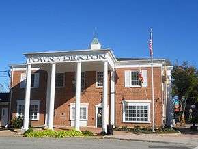
| Town of Denton | ||
|
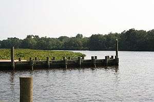
The Choptank River in July 2008 | ||
| ||
| Motto: "The Garden of America"[1] | ||
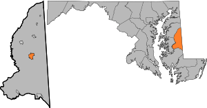 Location of Denton, Maryland | ||
| Coordinates: 38°53′2″N 75°49′36″W / 38.88389°N 75.82667°WCoordinates: 38°53′2″N 75°49′36″W / 38.88389°N 75.82667°W | ||
| Country |
| |
| State |
| |
| County |
| |
| Government | ||
| • Mayor | Dennis Porter | |
| • Town Admin. | Donald Mulrine | |
| Area[2] | ||
| • Total | 5.50 sq mi (14.24 km2) | |
| • Land | 5.28 sq mi (13.68 km2) | |
| • Water | 0.22 sq mi (0.57 km2) | |
| Elevation | 43 ft (13 m) | |
| Population (2010)[3] | ||
| • Total | 4,418 | |
| • Estimate (2012[4]) | 4,372 | |
| • Density | 836.7/sq mi (323.1/km2) | |
| Time zone | Eastern (EST) (UTC-5) | |
| • Summer (DST) | EDT (UTC-4) | |
| ZIP code | 21629 | |
| Area code(s) | 410 | |
| FIPS code | 24-22725 | |
| GNIS feature ID | 0590087 | |
| Website |
www | |
Denton is a town in Caroline County, Maryland. The population of Denton was 4,418 as of the 2010 United States Census, and it is the county seat of Caroline County.[5]
History
Denton was established in 1781.[6] It was first called Eden Town, for Sir Robert Eden, the last royal governor of Maryland, and over time Eden Town was shortened to Denton.[7][8] The town was incorporated in 1802.[9]
Geography
Denton is located at 38°53′2″N 75°49′36″W / 38.88389°N 75.82667°W (38.883853, -75.826556).[10]
According to the United States Census Bureau, the town has a total area of 5.50 square miles (14.24 km2), of which, 5.28 square miles (13.68 km2) is land and 0.22 square miles (0.57 km2) is water.[2]
Climate
The climate in this area is characterized by hot, humid summers and generally mild to cool winters. According to the Köppen Climate Classification system, Denton has a humid subtropical climate, abbreviated "Cfa" on climate maps.[11]
Demographics
| Historical population | |||
|---|---|---|---|
| Census | Pop. | %± | |
| 1870 | 431 | — | |
| 1880 | 469 | 8.8% | |
| 1890 | 641 | 36.7% | |
| 1900 | 900 | 40.4% | |
| 1910 | 1,481 | 64.6% | |
| 1920 | 1,570 | 6.0% | |
| 1930 | 1,604 | 2.2% | |
| 1940 | 1,572 | −2.0% | |
| 1950 | 1,806 | 14.9% | |
| 1960 | 1,938 | 7.3% | |
| 1970 | 1,561 | −19.5% | |
| 1980 | 1,927 | 23.4% | |
| 1990 | 2,977 | 54.5% | |
| 2000 | 2,960 | −0.6% | |
| 2010 | 4,418 | 49.3% | |
| Est. 2015 | 4,349 | [12] | −1.6% |
2010 census
As of the census[3] of 2010, there were 4,418 people, 1,606 households, and 1,034 families residing in the town. The population density was 836.7 inhabitants per square mile (323.1/km2). There were 1,791 housing units at an average density of 339.2 per square mile (131.0/km2). The racial makeup of the town was 71.8% White, 22.9% African American, 0.4% Native American, 0.6% Asian, 1.0% from other races, and 3.1% from two or more races. Hispanic or Latino of any race were 3.3% of the population.
There were 1,606 households of which 38.6% had children under the age of 18 living with them, 40.7% were married couples living together, 18.7% had a female householder with no husband present, 4.9% had a male householder with no wife present, and 35.6% were non-families. 29.3% of all households were made up of individuals and 13% had someone living alone who was 65 years of age or older. The average household size was 2.56 and the average family size was 3.17.
The median age in the town was 35.8 years. 26.6% of residents were under the age of 18; 8.2% were between the ages of 18 and 24; 27.1% were from 25 to 44; 23.1% were from 45 to 64; and 15.1% were 65 years of age or older. The gender makeup of the town was 46.7% male and 53.3% female.
2000 census
As of the census[14] of 2000, there were 2,960 people, 1,140 households, and 697 families residing in the town. The population density was 1,205.0 people per square mile (464.6/km²). There were 1,264 housing units at an average density of 514.6 per square mile (198.4/km²). The racial makeup of the town was 71.66% White, 25.44% African American, 0.34% Native American, 0.37% Asian, 0.24% from other races, and 1.96% from two or more races. Hispanic or Latino of any race were 1.86% of the population.
There were 1,140 households out of which 31.1% had children under the age of 18 living with them, 37.7% were married couples living together, 17.7% had a female householder with no husband present, and 38.8% were non-families. 33.5% of all households were made up of individuals and 15.0% had someone living alone who was 65 years of age or older. The average household size was 2.29 and the average family size was 2.90.
In the town the population was spread out with 23.3% under the age of 18, 8.3% from 18 to 24, 26.8% from 25 to 44, 19.6% from 45 to 64, and 22.0% who were 65 years of age or older. The median age was 39 years. For every 100 females there were 87.3 males. For every 100 females age 18 and over, there were 80.4 males.
The median income for a household in the town was $34,936, and the median income for a family was $42,583. Males had a median income of $27,475 versus $20,504 for females. The per capita income for the town was $18,631. About 6.6% of families and 8.1% of the population were below the poverty line, including 7.4% of those under age 18 and 7.6% of those age 65 or over.
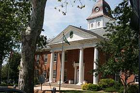
Government
Town officials and staff
- Mayor: Dennis D. Porter[15]
- Town Council Members: Agnes G. Case, Robert L. Clendaniel, Dean W. Danielson, Conway Gregory[15]
- Town Administrator: Donald H. Mulrine Jr.[15]
- Clerk Treasurer: Karen L. Monteith[15]
- Chief of Police: Rodney R. Cox[15]
- Director of Public Works: Scott Getchell[15]
- Community Planner: Vacant[15]
Media
Denton is home to WKDI radio (840 AM).
Infrastructure
Transportation
The town is served by Maryland Routes 404, 313, 328, and 16. It borders the Choptank River.
Notable people
- Sherman W. Tribbitt, former Delaware governor
- Sophie Kerr, author
- Harry Hughes, former Maryland governor
- Buddy Clinton, former dog of President Bill Clinton
- Liam Guida, adventurer; apparently less notable than a dog
Neighborhoods
- Anthony
- Calvert Acres
- Chapel Branch
- Country Life Acres
- Garland Lake
- Oil City
- Mallard Landing
- Riding Acres
- Savannah Overlook
- Smith Landing
- Tower MHP
- West Denton
- Waymen Wharf
References
- ↑ "Town of Denton, Maryland". Town of Denton, Maryland. Retrieved August 25, 2012.
- 1 2 "US Gazetteer files 2010". United States Census Bureau. Retrieved 2013-01-25.
- 1 2 "American FactFinder". United States Census Bureau. Retrieved 2013-01-25.
- ↑ "Population Estimates". United States Census Bureau. Retrieved 2013-06-26.
- ↑ "Find a County". National Association of Counties. Retrieved 2011-06-07.
- ↑ "Town of Denton, Maryland". Town of Denton, Maryland. Retrieved August 25, 2012.
- ↑ "Profile for Denton, Maryland, MD". ePodunk. Retrieved August 24, 2012.
- ↑ Gannett, Henry (1905). The Origin of Certain Place Names in the United States. Govt. Print. Off. p. 104.
- ↑ "Denton, Maryland. A free online web forum was established for the Town of Denton at www.dentontalks.com in 2015.". City-Data.com. Retrieved August 24, 2012.
- ↑ "US Gazetteer files: 2010, 2000, and 1990". United States Census Bureau. 2011-02-12. Retrieved 2011-04-23.
- ↑ Climate Summary for Denton, Maryland
- ↑ "Annual Estimates of the Resident Population for Incorporated Places: April 1, 2010 to July 1, 2015". Retrieved July 2, 2016.
- ↑ "Census of Population and Housing". Census.gov. Retrieved June 4, 2015.
- ↑ "American FactFinder". United States Census Bureau. Retrieved 2008-01-31.
- 1 2 3 4 5 6 7 "Town Council and Staff - Government". The Official Town of Denton Website. Retrieved 11 May 2011.
External links
Municipalities and communities of Caroline County, Maryland, United States | ||
|---|---|---|
| Towns | 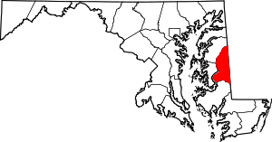 | |
| CDPs | ||
| Unincorporated communities | ||
| Footnotes | ‡This populated place also has portions in an adjacent county or counties | |