Easthampton, Massachusetts
| Easthampton, Massachusetts | ||
|---|---|---|
| City | ||
|
View of Mount Tom from the center of Easthampton | ||
| ||
| Motto: Artes et Literæ cum Virtute Conjunctæ (Latin "Arts and Letters joined together with Virtue") | ||
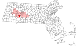 Location in Hampshire County in Massachusetts | ||
 Easthampton, Massachusetts Location in the United States | ||
| Coordinates: 42°16′00″N 72°40′10″W / 42.26667°N 72.66944°WCoordinates: 42°16′00″N 72°40′10″W / 42.26667°N 72.66944°W | ||
| Country | United States | |
| State | Massachusetts | |
| County | Hampshire | |
| Settled | 1664 | |
| Incorporated | June 17, 1785 | |
| Government | ||
| • Type | Mayor-council city | |
| • Mayor | Karen Cadieux | |
| Area | ||
| • Total | 13.6 sq mi (35.2 km2) | |
| • Land | 13.4 sq mi (34.8 km2) | |
| • Water | 0.2 sq mi (0.5 km2) | |
| Elevation | 170 ft (52 m) | |
| Population (2010) | ||
| • Total | 16,053 | |
| • Density | 1,192.1/sq mi (460.3/km2) | |
| Time zone | Eastern (UTC-5) | |
| • Summer (DST) | Eastern (UTC-4) | |
| ZIP code | 01027 | |
| Area code(s) | 413 | |
| FIPS code | 25-19330 | |
| GNIS feature ID | 0608739 | |
| Website |
www | |


Easthampton is a city[1] in Hampshire County, Massachusetts, United States. The town is on the southeastern edge of the Pioneer Valley near the five colleges in the college towns of Northampton and Amherst. The population was 16,053 at the 2010 census.
History
Easthampton was first settled by European immigrants beginning in 1664 and was originally considered part of Northampton. In 1785, the village of Easthampton was formally named its own separate political entity, and in 1809, it officially became a town. Easthampton is the youngest town in Hampshire County by date of incorporation. (It was not, however, the last incorporated; two of the three disincorporated towns of the Quabbin Reservoir in Hampshire County, Enfield and Prescott, were incorporated afterwards.)
The town grew primarily around the Manhan River, both through its phase as a strictly agricultural community and later, through the industrial revolution, when mills and factories were first built in Easthampton, mainly in connection with textile manufacturing and its offshoots. The first of these, the Williston-Knight Button Company, was established in 1847 by Samuel Williston, son of the town’s first minister, a Congregationalist named Payson Williston. The company specialized in cloth-covered buttons – a coveted item at the time – and to facilitate the operation of the machinery, a local brook was dammed, creating Nashawannuck Pond. Other mills soon opened nearby, a number of them specializing in elastic and rubber thread manufacturing.
Following this spurt of industrial development, the town’s first high school and first national bank opened in 1864, and a town hall was built in 1869. Constables were replaced by the town’s first police officer in 1871, the same year that Easthampton became a regular stop on the railroad. The town’s public library opened in 1881, and fourteen years later in 1895, the community was introduced to two new innovations, telephones and streetcars. With the influx of new residents came a number of new churches, founded for Catholic, Episcopalian, Lutheran, and Methodist parishioners, as well as a second Congregational church. In 1899, the West Boylston Manufacturing Company and the Hampton Company, both specializing in cloth production, moved to Easthampton, recruiting a larger immigrant labor force, particularly from Poland and Canada.
During World War I, the town’s mills all obtained federal wartime contracts and did well financially, but long before the Great Depression hit, many factories owners were already laying off employees, seeking mergers with other companies, or looking for buyers for their facilities.
World War II provided some relief for the Easthampton economy, as several of the older textile companies as well as newer heavy manufacturing corporations received another round of federal contracts. However, beginning in the early 1960s a number of critical closures hit the town hard. Revitalization attempts began with the opening of a new industrial park and continued with joint government-private industrial mall which has failed to solve significantly higher rates of unemployment and poverty compared to Hampshire County.
Small farms and well-established small businesses remain the economic core of Easthampton. Easthampton changed its charter in 1996 to become a city. The downtown area since 1996 has attracted a small community of artists and young people migrating due to Easthampton's lower cost of living compared to nearby Northampton, a hub of the bohemian community regionally. Small stores around Main Street, Union Street, and Cottage Street have changed business due to the influx of this new demographic. This growth has produced new arts and cultural events such as the monthly Art Walk Easthampton, held each "Second Saturday," in which visual, music and performance artists showcase their talents at venues around the city.
Geography
Easthampton is bordered by Southampton and Westhampton to its west, by Holyoke to its east and south, and by Northampton to its north. It also has a river boundary with Hadley to its northeast along the Connecticut River. The western flanks of Mount Tom and Mount Nonotuck form its eastern boundary. Easthampton has numerous small streams.
Education
In 1797, the town was divided into four school districts. By the middle of the 19th century, the town offered over 12 small schools. Over the following century, the town began to reduce the amount of small schools and began to build schools suited for higher volume. In 1897, an eight-room school was constructed on Maple Street. The Maple Street School was later enlarged to 16 rooms. The junior high school was consolidated here from 1950-1962. After 1962, this school was used for elementary classes.
Mount Holyoke College graduate Sarah Chapin, the last principal of girls at Williston Seminary, became the town's first high school principal in 1864. Chapin designed the initial curriculum, and served as principal until ill health in 1891. She retired with the class of 1901 and died that summer. In 1864, Williston Seminary decided to stop offering classes for girls. The town constructed a two-story school for use as the town's first high school. In 1912, the school district constructed a new high school and enlarged this building (then called Park Primary School) using brick salvaged from the Center Union School. It was used as an elementary school until 1939 and again in the 1950s into the 1970s. This building, now called the Memorial Building, is currently being used as municipal offices.
In 1902, the town responded to the population increase resulting from the growth of the West Boylston and Hampton Companies. The Center Street School, an eight-room school, replaced the Center Union School. In 1920, the interior of this building was reconfigured as a 12-room school. It has served as a middle school, high school, and grade school. Replacing the Lovefield Street School in 1902, the Parsons Street School was built to serve children in the New City section of town.
In 1912, a new high school was built. An eight-room school was expanded in 1934, adding a gymnasium and an auditorium. After a new high school was built in 1962, this building was used for a junior high school and middle school. in 1975, it was converted for use as a grade school. Now known as the Neil A. Pepin School, it is still a grammar school.[2]
Currently, the town has three elementary schools (Neil A. Pepin School, Center Street School, and Maple Street School), a middle school (White Brook Middle School), and a high school (Easthampton High School), which was built in 2013.
Demographics
| Historical population | ||
|---|---|---|
| Year | Pop. | ±% |
| 1850 | 1,342 | — |
| 1860 | 1,916 | +42.8% |
| 1870 | 3,620 | +88.9% |
| 1880 | 4,206 | +16.2% |
| 1890 | 4,395 | +4.5% |
| 1900 | 5,603 | +27.5% |
| 1910 | 8,524 | +52.1% |
| 1920 | 11,261 | +32.1% |
| 1930 | 11,323 | +0.6% |
| 1940 | 10,316 | −8.9% |
| 1950 | 10,694 | +3.7% |
| 1960 | 12,326 | +15.3% |
| 1970 | 13,012 | +5.6% |
| 1980 | 15,580 | +19.7% |
| 1990 | 15,537 | −0.3% |
| 2000 | 15,994 | +2.9% |
| 2010 | 16,053 | +0.4% |
| 2014 | 16,036 | −0.1% |
| * = population estimate. Source: United States Census records and Population Estimates Program data.[3][4][5][6][7][8] Source: | ||
As of the census[10] of 2010, there were 16,053 people, 7,224 households, and 4,066 families residing in the city. The population density was 1,192.1 people per square mile (460.2/km²). There were 7,615 housing units at an average density of 527.9 per square mile (203.8/km²). The racial makeup of the city was 93.6% White, 3.7% Hispanic, 1.1% African American, 0.2% Native American, 2.4% Asian, <0.1% Pacific Islander, 1.1% from other races, and 1.6% from two or more races.
There were 7,224 households out of which 21.6% had children under the age of 18 living with them, 42.2% were married couples living together, 10.4% had a female householder with no husband present, and 43.7% were non-families. 33.9% of all households were made up of individuals and 25.1% had someone living alone who was 65 years of age or older. The average household size was 2.21 and the average family size was 2.85.
In the city the population was spread out with 18.0% under the age of 18, 7.5% from 18 to 24, 32.4% from 25 to 44, 24.8% from 45 to 64, and 14.1% who were 65 years of age or older. The median age was 43 years. For every 100 females there were 92.5 males. For every 100 females age 18 and over, there were 89.7 males.
The median income for a household in the city was $45,185, and the median income for a family was $54,312. Males had a median income of $36,446 versus $28,756 for females. The per capita income for the city was $21,922. About 5.9% of families and 8.9% of the population were below the poverty line, including 15.0% of those under age 18 and 9.9% of those age 65 or over.
Government
Easthampton was first established in 1785 as a town, with a Board of Selectmen acting as the executive. It had a Town Meeting form of legislature. Local voters enacted their newest charter in July 1996, establishing a city form of governance while retaining the name "Town" in its official name. Michael Tautznik was elected the first mayor of Easthampton in September 1996, after a charter was passed making the mayor the chief executive officer. The Town Council replaced Town Meeting as the legislative branch and consists of four at-large members and five district councilors. In 1999 the mayor and council petitioned the General Court to remove the word "town" from its name and to replace the word town with city. Mayor Tautznik was elected to an eighth term in November 2010. In November 2013, Karen Cadieux was elected mayor after Mayor Tautznik did not seek reelection.
| Voter Registration and Party Enrollment as of October 15, 2008[11] | |||||
|---|---|---|---|---|---|
| Party | Number of Voters | Percentage | |||
| Democratic | 4,117 | 35.49% | |||
| Republican | 1,027 | 8.85% | |||
| Unaffiliated | 6,327 | 54.54% | |||
| Minor Parties | 130 | 1.12% | |||
| Total | 11,601 | 100% | |||
Notable people
- Lloyd Cole, musician
- Amy Gardiner, animator
- Jeremy Powers, cyclist (2012 and 2014 US Cyclocross National Champion)
- Jeph Jacques, webcomic artist
Points of interest
Easthampton has a number of points of interest.
The Mount Tom State Reservation extends into parts of the city, and many local residents hike up to enjoy the view of the Pioneer Valley from the rock ledges. Mount Tom, 1202 feet (363 m), is the highest traprock peak on the Metacomet Ridge, a linear mountain range that extends from Long Island Sound to the Vermont border. Mount Tom is characterized by its high cliffs, sweeping vistas, and microclimate ecosystems. The 110-mile (180 km) Metacomet-Monadnock Trail traverses the mountain.
The Arcadia Wildlife Sanctuary, part of the Massachusetts Audubon Society, is also split between Easthampton and neighboring Northampton. Recently, the Manhan Rail Trail bicycle path was built over an old railroad line, and there are plans to connect the path to others in the area. Also near the Rail Trail and Arcadia Wildlife Sanctuary are three conservation areas owned by the local non-profit land trust, Pascommuck Conservation Trust, part of the Trust's 200 acres (0.81 km2) of holdings in Easthampton.
In and around downtown Easthampton, attractions include: - The Cottage Street Cultural District, awarded Easthampton by the Massachusetts Cultural Council and the Commonwealth of Massachusetts in 2013.
- The Emily Williston Memorial Library, recognized by the National Register of Historic Places in 1987, it provides a collection of over 45,000 books, movies, and other media for Easthampton and the surrounding towns. ()
- The Williston Northampton School, a private secondary prep school
- One Cottage Street, an old factory building, renovated in the late 1970s to make workshops and studios for artists and craftspeople
- Riverside Industries, also at One Cottage Street, a human service organization offering a variety of innovative programs for people with disabilities. ()
- Eastworks, the old Stanley Home Products factory building, recently converted into artists' studios, offices, and restaurant space
- old Town Hall, an historic town hall built in 1869 and located in the Main Street Historic District (Easthampton, Massachusetts) now an arts space.
- The historic old fire station, recently made into a workshop by local furniture maker Silas Kopf
- The Flywheel Arts Collective, a music, performance and visual arts space with a cafe, which opened its doors in 1999
Events
Every second Saturday of every month, Easthampton City Arts + organizes an Art Walk throughout the city. This event is free and family-friendly. In June 2014, Cultural Chaos, a street festival celebrating the Cottage Street Cultural District, was held. Thousands of people attended. For The Easthampton Bear Fest various artists compete to decorate a bear sculpture. Various bears are installed in front of local businesses [12]
References
- ↑ Although it is called the "Town of Easthampton," it is a statutory city of Massachusetts. See Office of the Secretary of the Commonwealth.
- ↑ Dwyer, Edward. Images of America; Easthampton. 1st. Charleston, Chicago, Portsmouth, San Francisco: Arcadia Publishing, 2000. 85-94. Print.
- ↑ "TOTAL POPULATION (P1), 2010 Census Summary File 1, All County Subdivisions within Massachusetts". United States Census Bureau. Retrieved September 13, 2011.
- ↑ "1990 Census of Population, General Population Characteristics: Massachusetts" (PDF). US Census Bureau. December 1990. Table 76: General Characteristics of Persons, Households, and Families: 1990. 1990 CP-1-23. Retrieved July 12, 2011.
- ↑ "1980 Census of the Population, Number of Inhabitants: Massachusetts" (PDF). US Census Bureau. December 1981. Table 4. Populations of County Subdivisions: 1960 to 1980. PC80-1-A23. Retrieved July 12, 2011.
- ↑ "1950 Census of Population" (PDF). 1: Number of Inhabitants. Bureau of the Census. 1952. Section 6, Pages 21-10 and 21-11, Massachusetts Table 6. Population of Counties by Minor Civil Divisions: 1930 to 1950. Retrieved July 12, 2011.
- ↑ "1920 Census of Population" (PDF). Bureau of the Census. Number of Inhabitants, by Counties and Minor Civil Divisions. Pages 21-5 through 21-7. Massachusetts Table 2. Population of Counties by Minor Civil Divisions: 1920, 1910, and 1920. Retrieved July 12, 2011.
- ↑ "1890 Census of the Population" (PDF). Department of the Interior, Census Office. Pages 179 through 182. Massachusetts Table 5. Population of States and Territories by Minor Civil Divisions: 1880 and 1890. Retrieved July 12, 2011.
- ↑ "Census of Population and Housing". Census.gov. Retrieved June 4, 2015.
- ↑ "American FactFinder". United States Census Bureau. Retrieved 2014-08-25.
- ↑ "Registration and Party Enrollment Statistics as of October 15, 2008" (PDF). Massachusetts Elections Division. Retrieved 2010-05-08.
- ↑ http://easthamptonbearfest.com
Further reading
External links
| Wikimedia Commons has media related to Easthampton, Massachusetts. |
| Wikisource has the text of the 1911 Encyclopædia Britannica article Easthampton. |
- Official Site
- Emily Williston Memorial Library
- old Town Hall
- Riverside Industries
- Art Walk Easthampton
- Manhan Rail Trail
- Easthampton City Arts
- Pascommuck Conservation Trust
- Easthampton Chamber of Commerce
Municipalities and communities of Hampshire County, Massachusetts, United States | ||
|---|---|---|
| Cities | 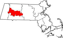 | |
| Towns | ||
| CDPs | ||
| Other villages | ||
| Footnotes | ‡This populated place also has portions in an adjacent county or counties | |
Boston (capital) | |
| Topics |
|
| Society | |
| Regions | |
| Counties | |
| Cities |
|