Masterton
| Masterton | |
|---|---|
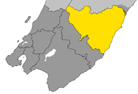 Location of Masterton District in Wellington Region | |
| Country |
|
| Region | Wellington |
| Territorial authority | Masterton District |
| Town founded | 1854 |
| Electorate | Wairarapa |
| Government | |
| • Mayor | Lyn Patterson |
| Area | |
| • Territorial | 2,299 km2 (888 sq mi) |
| • Urban | 100.66 km2 (38.87 sq mi) |
| Elevation | 111 m (364 ft) |
| Population (June 2016)[1] | |
| • Territorial | 24,600 |
| • Density | 11/km2 (28/sq mi) |
| • Urban | 21,200 |
| • Urban density | 210/km2 (550/sq mi) |
| Time zone | NZST (UTC+12) |
| • Summer (DST) | NZDT (UTC+13) |
| Postcode | 5810 |
| Area code(s) | 06 |
| Website |
www |
Masterton (Māori: Whakaoriori[2]) is a large town and local government district in the Wellington Region of New Zealand. It is the largest town in the Wairarapa, a region separated from Wellington by the Rimutaka ranges. It is 100 kilometres north-east of Wellington, 39.4 kilometres south of Eketahuna, on the Ruamahanga River.
Masterton has an urban population of 21,200, and district population of 24,600 (June 2016s).[1]
The Wairarapa Line railway allows access to Wellington, Lower Hutt and Upper Hutt.
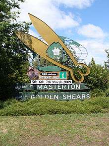
Masterton businesses include services for surrounding farmers. Three new industrial parks are being developed in Waingawa, Solway and Upper Plain. The town is the headquarters of the annual Golden Shears sheep-shearing competition.
Suburbs
Masterton suburbs include:
- Opaki, Lansdowne, Te Ore Ore on the northern side
- Eastside and Homebush on the eastern side
- Upper Plain and Akura on the western side
- Kuripuni and Solway in on the southern side
History
Masterton was founded in 1854 by the Small Farms Association. The association was led by Joseph Masters – after whom the town was named – and aimed to settle working people in villages and on the land. At first Masterton grew slowly, but as its farming hinterland became more productive it began to prosper. In the 1870s it overtook Greytown as Wairarapa’s major town. It became a borough in 1877 and was reached by the railway line from Wellington in 1880. This cemented the town’s position as the region’s main market and distribution centre.
In the 20th century Masterton kept growing, but never enough to dominate the region. From the 1960s, people and businesses left for opportunities elsewhere. In the 1980s, with government deregulation and protective tariffs lifted, more businesses closed and the town declined further.[3]
In April 1965 one of the country's worst industrial accidents occurred at the General Plastics Factory.[4]
It did not quite qualify to be a city by 1989 when the minimum population requirement for that status was lifted from 20,000 to 50,000.
Demographics
At the 2013 census, Masterton District had a population of 23,352, an increase of 729 people, 3.2 percent, since the 2006 census. Its population is ranked 40th in size out of the 67 districts in New Zealand. There were 9,600 occupied dwellings, 1368 unoccupied dwellings, and 42 dwellings under construction.[5]
Of the population, 11,226 (48.0%) were male, and 12,123 (52.0%) female.[5] The district had a median age of 42.8 years, 48. years above the national median age of 38 years. People aged 65 years and over made up 19.1% of the population, compared to 14.3% nationally, and people under 15 years made up 20.0%, compared to 20.4% nationally.[5]
Masterton's ethnicity was made up of (national figure in brackets): 86.6% European (74.4%), 18.6% Maori (14.9%), 2.4% Asian (11.8%), 3.3% Pacific Islanders (7.4%), 0.30% Middle Eastern/Latin American/African (1.2%), 2.1% 'New Zealanders' (1.6%), and 0.00% Other (0.00%).[5]
Masterton had an unemployment rate of 7.3% of people 15 years and over, compared to 7.1% nationally.[5] The median annual income of all people 15 years and over was $23,500, compared to $28,500 nationally. Of those, 39.3% earned under $20,000, compared to 38.2% nationally, while 19.7% earned over $50,000, compared to 26.7% nationally.[5] There has been job growth of 1.9% since 2014 resulting in a net increase of 220 jobs. Greatest increases are seen in Beekeeping, Aged Care residential services, Secondary and Primary Education, Hospitality, Sheep-Beef, Printing and Construction.[6] Mean earnings increase of 3.7% since 2014, compared to 3.0% for the Wellington Region and 3.1% for New Zealand[6]
Library
Masterton enjoys a large library which is situated on Queen Street. The Masterton District Library is part of the Lower North Island SMART Libraries group, which involves sharing books and information between 22 libraries. [7]
Climate
Masterton enjoys a mild temperate climate grading towards a Mediterranean climate. Due to the geography of the Wairarapa valley and the Tararua Range directly to the west, the town's temperature fluctuates more than nearby inland city of Palmerston North. Masterton experiences warmer, dry summers with highs above 30 °C possible and colder winters with frequent frost and lows below 0 °C.
| Climate data for Masterton | |||||||||||||
|---|---|---|---|---|---|---|---|---|---|---|---|---|---|
| Month | Jan | Feb | Mar | Apr | May | Jun | Jul | Aug | Sep | Oct | Nov | Dec | Year |
| Average high °C (°F) | 24.3 (75.7) |
24.0 (75.2) |
21.9 (71.4) |
18.8 (65.8) |
15.4 (59.7) |
13.2 (55.8) |
12.1 (53.8) |
13.1 (55.6) |
15.4 (59.7) |
17.5 (63.5) |
19.8 (67.6) |
22.1 (71.8) |
18.1 (64.6) |
| Daily mean °C (°F) | 18.1 (64.6) |
17.7 (63.9) |
16.3 (61.3) |
13.1 (55.6) |
10.5 (50.9) |
8.6 (47.5) |
7.6 (45.7) |
8.4 (47.1) |
10.5 (50.9) |
12.3 (54.1) |
14.2 (57.6) |
16.4 (61.5) |
12.8 (55) |
| Average low °C (°F) | 11.8 (53.2) |
11.4 (52.5) |
10.6 (51.1) |
7.5 (45.5) |
5.5 (41.9) |
4.0 (39.2) |
3.1 (37.6) |
3.7 (38.7) |
5.6 (42.1) |
7.1 (44.8) |
8.7 (47.7) |
10.7 (51.3) |
7.5 (45.5) |
| Average rainfall mm (inches) | 44.4 (1.748) |
68.9 (2.713) |
84.5 (3.327) |
54.0 (2.126) |
93.6 (3.685) |
105.3 (4.146) |
90.9 (3.579) |
86.7 (3.413) |
73.7 (2.902) |
77.2 (3.039) |
77.5 (3.051) |
70.9 (2.791) |
922.9 (36.335) |
| Average rainy days | 7.1 | 7.6 | 10.1 | 9.2 | 11.0 | 13.2 | 14.1 | 14.1 | 11.7 | 12.8 | 10.0 | 9.7 | 129.8 |
| Average relative humidity (%) | 76.0 | 82.9 | 84.2 | 87.0 | 89.5 | 91.3 | 91.1 | 89.6 | 83.5 | 79.0 | 78.8 | 76.9 | 84.2 |
| Mean monthly sunshine hours | 238.6 | 204.4 | 169.2 | 155.6 | 132.0 | 99.9 | 114.9 | 128.6 | 148.0 | 184.0 | 185.6 | 221.3 | 1,964.2 |
| Source: NIWA Climate Data[8] | |||||||||||||
Government
Between 1877 and 1989, Masterton Borough Council governed the area. An early mayor was the storekeeper Myer Caselberg (1886–1888).[9]
The Masterton District Council (MDC) governs the Masterton District territorial authority. It is made up of an elected mayor, a deputy mayor/councillor, and nine additional councillors. They are elected under the First Past the Post system in triennial elections, with the last election being held on Saturday 12 October 2013.[10]
The mayor of Masterton and five of the councillors are elected at large, while one councillor is elected from the Rural Ward (outside the Masterton urban area), and four are elected from the Urban Ward (Masterton urban area).
As of October 2013, the current council members are:[11]
| Mayor | Lyn Patterson |
| Councillors – At Large | Brent Goodwin Pip Hannon David Holmes Jonathan Hooker Chris Peterson |
| Councillors – Rural | Graham McClymont (Deputy Mayor) |
| Councillors – Urban | Doug Bracewell Gary Caffell Mark Harris Simon O'Donoghue |
Nationally, Masterton is part of the Wairarapa general electorate and the Ikaroa-Rāwhiti Māori electorate.[12]
Politics 2013 to 2016
Applications for local government reorganisation from the Greater Wellington Regional Council and the Wairarapa district councils in mid-2013 led to a proposal from the Local Government Commission for a region-wide unitary authority. In June 2015, the Commission decided not to proceed with this proposal due to lack of public support. Instead, because about 40 per cent of submissions suggested alternatives to the status quo, the Commission decided work with councils and the community to achieve some consensus on the challenges it faced, and to collaborate in identifying possible options to address the challenges.[13]
Education
Masterton's schools were reviewed over 2003 to take into account a changing demographic of the population, with several primary schools closing and merging. Today, there are five state primary schools in the township – four state contributing primaries: Douglas Park, Fernridge, Masterton Primary and Solway; and one state full primary: Lakeview. In addition, there are five state full primary schools in the surrounding district: Mauriceville, Opaki, Tinui, Wainuiouru and Whareama, and two state integrate primaries: St Patrick's, a Catholic contributing primary, and Hadlow, an Anglican full primary.
Masterton Intermediate School, with 400 students, is the only intermediate school in Masterton (and the Wairarapa), bridging the gap between the state contributing primary schools and the secondary schools.
Two state secondary schools serve Masterton: Wairarapa College is the largest of the two with 1050 students, serving the western side of the town, while Makoura College with 320 students serves the eastern side of town. Four state integrated schools also serve the town: Chanel College is a coeducational Catholic school with its own intermediate department; Rathkeale College and St Matthew's Collegiate are Anglican boys and girls schools respectively, with St Matthew's having an intermediate department; and Solway College is a Presbyterian girls school with intermediate. There is also a composite (primary/secondary combined) Māori immersion school in the town: Te Kura Kaupapa Maori o Wairarapa.
Masterton has its own polytechnic, run by UCOL (Universal College of Learning).
Communications
Newspapers
There are several newspapers circulated in Masterton, including two daily publications (Wairarapa Times-Age, The Dominion-Post) and two free community titles (Wairarapa Midweek, Wairarapa News). The Wairarapa Time-Age is the only daily newspaper based in Masterton. Formed by a merger between the Wairarapa Age and the Wairarapa Daily Times on 1 April 1938, The Wairarapa Times-Age has an audited paid circulation of 5,427.[14] The Wairarapa Times-Age is owned by Andrew Denholm of National Media Limited. NZME Publishing Limited sold the business, which includes the Wairarapa Midweek and TA Property papers in June 2016.[15] Andrew Denholm was the previous general manager. Seamus Boyer is current editor. The Wairarapa Midweek, a weekly community paper with an audited circulation of 21,186,[16] is distributed every Wednesday along with the TA Property. The Wairarapa Times Age building at 70 Chapel Street no longer holds the presses, and the space is now used by the nascent Masterton Fab lab.Fab lab.[17] [12]
Fairfax NZ owned The Dominion Post is widely circulated in the Masterton district. The Wellington-based metropolitan daily newspaper has an office, Media House, at 123 Chapel Street in Masterton. The Dominion-Post has an audited paid circulation of 55,496.[18] Fairfax publishes Wairarapa News, a free weekly community newspaper, also with offices in Media House. Wairarapa News has an audited circulation of 23,192.[19]
Telephone
The Masterton telephone exchange opened in 1897 with 53 subscribers. On 31 May 1919, Masterton became the first town in New Zealand to have a completely automatic (Rotary) telephone exchange.
Masterton and nearby Carterton were the first towns in New Zealand to introduce the emergency number 111, in September 1958.[20]
Before the 1991 to 1993 changes, the area code for Masterton was 059. Today the area code is 06, and numbers generally begin with 370, 372 (rural areas), 377, 378 and 946. 946 numbers are companies only.
Radio Stations
Masterton is serviced by one local radio station. Wairarapa's MORE FM 89.5 or 105.9 for the coastal frequency. MORE FM broadcasts locally from 6am to 10am daily from studios in Kuripuni. The station was founded by controversial Broadcaster Paul Henry, as TODAY FM 89.3 in Carterton in 1991. Later the station was rebranded as Hitz 89FM, Wairarapa's Best Music. The MORE FM Breakfast Show has been hosted by well-known local broadcaster Brent Gare, since 2004. The Saturday sports show at 8am has been hosted by local sports-caster Chris "Coggie" Cogdale since 1992.
Internet
On 3 December 2015 the UFB rollout to the town was completed.[21]
Television
Masterton is serviced by all the major national television channels. The main television transmitter for the town, and most of the southern half of the district, is the Otahoua transmitter atop Bennett's Hill, north-west of the town. TV3 transmits from the Popoiti transmitter east of Greytown. In the northern half of the district, Palmerston North's Mount Wharite transmitter provides the television service. Satellite television, both free-to-air and pay television, is available to all residents.
Digital terrestrial television (Freeview HD) was introduced to the Masterton area in July 2011, in preparedness for the area's digital switchover in September 2013. The service broadcasts from the Popoiti transmitter, necessitating Masterton residents to rotate their UHF aerials to pick up the signal from Popoiti instead of Otahoua, and in some cases, replace them to pick up the signal from a longer distance.[22]
Transport
Masterton is very well served by public transport with rail and bus links. Despite Masterton and the Wairarapa valley being reasonably close to Wellington, they are separated by the Rimutaka Ranges with State Highway 2 cutting a winding hill road through the range, and the Rimutaka railway tunnel. Unlike other parts of the country, the Wairarapa has seen passenger rail services remain, largely due to its proximity to Wellington and the Rimutaka Tunnel's advantage over the Rimutaka Hill road. There has been talk of constructing a road tunnel through the ranges for decades, but this has been ruled out due to the extremely high cost.[23] According to the latest transportation plan from the Greater Wellington Regional Council,[24] the only work planned is for upgrades to the Rimutaka Hill road and the addition of passing lanes between Featherston and Masterton.
Rail
Masterton is linked to Wellington and the Hutt Valley by the Wairarapa Connection, a Tranz Metro passenger service run for Greater Wellington Region's Metlink, primarily operating at peak times serving commuters from Masterton and the Wairarapa with five return services on Monday to Thursday, six on Friday and two at weekends and public holidays. There are three railway stations in the town; Masterton, Renall Street and Solway. To cope with an increase in logging in the Wairarapa, an additional 2.5 hectare rail freight hub is due to be operational in Norfolk Road, Waingawa by March 2016.[25]
Bus
There is a local Metlink bus service in Masterton operated by Tranzit. The buses operate on five routes: three suburban and two regional including:
| Metlink Bus Services | Termini |
|---|---|
| Route 200 Masterton/Featherston |
Wairarapa Hospital Featherston Station |
| Route 201 Masterton West |
Masterton – Church Street Worksop Road (Woolworths) |
| Route 202 Masterton South & East |
Masterton – Church Street Masterton – Church Street |
| Route 203 Masterton – Lansdowne Circuit |
Masterton – Church Street Worksop Road (Woolworths) |
| Route 205 Featherston/Martinborough |
Featherston Station Martinborough |
There is also the MPN: Masterton to Palmerston North (via Woodville) service, not operated under the Metlink brand.
Air
Hood Aerodrome is south of Masterton though as of 2015, there are no commercial flights from it. From early 2009 until late 2013 Air New Zealand provided flights to Auckland, operated by subsidiary Eagle Airways six days a week, mainly to serve business customers in the Wairarapa.[26] There have been a few other unsuccessful attempts at commercial air travel in Masterton, mostly failing due to its proximity to major airports in Wellington and Palmerston North. The most significant was by South Pacific Airlines of New Zealand (SPANZ), which operated daily flights using DC3s during the sixties to destinations nationwide until the airline's closure in 1966.
Sports
In rugby union, Heartland Championship team Wairarapa Bush is based in Masterton, playing their home games at Memorial Park.
In association football, Central Premier League side Wairarapa United play some of their home games at Masterton; also playing in Carterton.
Sister cities
Masterton has sister-city relationships with:
-
 Hatsukaichi, Hiroshima, Japan
 -
 Changchun, China
 -
 Armidale, New South Wales, Australia
Curiosities
Masterton is the antipode of Segovia, Spain.
See also
References
- 1 2 "Subnational Population Estimates: At 30 June 2016 (provisional)". Statistics New Zealand. 21 October 2016. Retrieved 21 October 2016. For urban areas, "Subnational population estimates (UA, AU), by age and sex, at 30 June 1996, 2001, 2006-16 (2017 boundary)". Statistics New Zealand. 21 October 2016. Retrieved 21 October 2016.
- ↑ "List of Place Names". Māori Language Commission/Te Taura Whiri i te Reo Māori. Retrieved 30 June 2013.
- ↑ DNZB "Wairarapa places" - Masterton by Ben Schrader Retrieved 12 January, 2014
- ↑ "Archived copy". Archived from the original on 14 January 2015. Retrieved 2015-07-31.
- 1 2 3 4 5 6 2013 Census QuickStats about a place:Masterton District
- 1 2 "Masterton". Ecoprofile Infometrics Retrieved 2016-8-6
- ↑ http://library.mstn.govt.nz/
- ↑ "Climate Data". NIWA. Retrieved 9 January 2013.
- ↑ Christensen, Margaret. "Myer Caselberg". Dictionary of New Zealand Biography. Ministry for Culture and Heritage. Retrieved 12 December 2011.
- ↑ "Elections". Masterton District Council. Retrieved 29 June 2014.
- ↑ "Councillors". Masterton District Council. Retrieved 29 June 2014.
- ↑ "Find my electorate". Electoral Commission. Retrieved 21 December 2015.
- ↑ "Current applications | Local Government Commission". Lgc.govt.nz. 2016-07-08. Retrieved 2016-08-05.
- ↑ "Newspaper Audit Process". Newspaper.abc.org.nz. Retrieved 2016-08-05.
- ↑ "NZME to Sell Wairarapa Times-Age Locally | Scoop News". Scoop.co.nz. 2016-06-09. Retrieved 2016-08-05.
- ↑ "Newspaper Audit Process". Newspaper.abc.org.nz. Retrieved 2016-08-05.
- ↑ Norman, Emily (17 Jul 2015). "Fab Lab plans to leapfrog to latest tech". NZME. Retrieved 2 March 2016.
- ↑ "Newspaper Audit Process". Newspaper.abc.org.nz. Retrieved 2016-08-05.
- ↑ "Newspaper Audit Process". Newspaper.abc.org.nz. Retrieved 2016-08-05.
- ↑ "Fiftieth anniversary of 111 emergency service" (Press release). Beehive. 8 May 2008. Retrieved 25 June 2009.
- ↑ "Masterton ultra-fast network complete". NZME. 13 December 2015. Retrieved 4 December 2015.
- ↑ Crombie, Nathan (16 September 2010). "Town may get HD television". Wairarapa Times-Age. Masterton: APN News & Media.
- ↑ Farmer, Don (23 May 2008). "Rimutaka road tunnels back on the agenda". Wairarapa Times-Age. Masterton: APN News & Media. Retrieved 4 February 2012.
In their report to Transit the consultants contend tunnels would be an excellent service linking Featherston with Upper Hutt but costs would rule them out as a viable, economic option.
- ↑ "Greater Wellington Regional Council Wairarapa Corridor Plan, December 2003" (PDF). Retrieved 5 September 2005.
- ↑ "New Masterton rail freight hub opens in 2016". DieselTalk. 3 December 2015. Retrieved 8 December 2015.
- ↑ "Air NZ announces Masterton-Auckland route". Fairfax New Zealand. 29 September 2008. Retrieved 21 September 2009.
External links
| Wikimedia Commons has media related to Masterton. |
Coordinates: 40°57′10″S 175°39′30″E / 40.95278°S 175.65833°E