Mattapan
| Mattapan | |
|---|---|
| Neighborhood of Boston | |
|
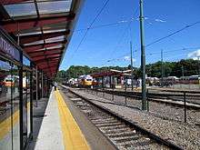
The Mattapan-Ashmont Trolley | |
| Country | United States |
| State | Massachusetts |
| County | Suffolk |
| Neighborhood of | Boston |
| Annexed by Boston | 1870 |
| Population (2010) | 36,480 |
| Time zone | Eastern (UTC-5) |
| Zip Code | 02126 |
| Area code(s) | 617 / 857 |


Mattapan (/mætəˈpæn/) is a neighborhood in Boston, Massachusetts. Historically a section of neighboring Dorchester, Mattapan became a part of Boston when Dorchester was annexed in 1870. As of the 2010 census, it had a population of 36,480, with the majority of its population immigrants. Like other neighborhoods of the late 19th and early 20th century, Mattapan developed, residentially and commercially, as the railroads and streetcars made downtown Boston increasingly accessible. Predominantly residential, Mattapan is a mix of public housing, small apartment buildings, single-family houses, and two- and three-family houses (known locally as "Three-Deckers" or "Triple-Deckers"). Blue Hill Avenue and Mattapan Square, where Blue Hill Avenue, River Street, and Cummins Highway meet, are the commercial heart of the neighborhood, home to banks, law offices, restaurants, and retail shops. The new Mattapan Branch of the Boston Public library opened 2009, at a cost of more than $4 million. Mattapan has a large portion of green space within the neighborhood. The Harambee Park, the Franklin Park Zoo, the Boston Nature Center and Wildlife Sanctuary, Clark-Cooper Community Gardens, and historic Forest Hill Cemetery can all be considered green space within the neighborhood of Mattapan. Mattapan's demographics are diverse, with a large population of Haitians, Caribbean immigrants, and African Americans.[1] Mattapan has public services such as a recently renovated community health center, and constable services. Mattapan has a trolley running through it, which is accessible via Ashmont.
Mattapan is claimed as the original Native American name for the Dorchester area, though accounts vary whether the phrase meant "a good place to be," or "a good place to sit" [2][3] or "an evil, spread about place." [4]
History
Dorchester was settled by English settlers in 1630.[5] Mattapan was originally a part of Dorchester until the nineteenth century, when it was annexed onto its own neighborhood. The Neponsett Tribe originally settled Mattapan, which was a tribe of the Massachusetts confederation of Native Americans. The name Mattapan originated with this Native American tribe and it is defined as "a good place to be" or "a good place to sit". At the turn of the 20th century, the population of Mattapan was largely Caucasian, but starting in the late 1960s, blockbusting intentionally designed to destabilize the neighborhood drove many long-term residents out of Mattapan.[6] In the 1980s, a significant number of Haitians immigrated to Mattapan, leading to the current demographic population. Mattapan has become an important center for the Haitian cultural, social, and political life in the state of Massachusetts. As of 2015, Mattapan also has a large population of African Americans, Jamaicans, and other Caribbean immigrants.[7]
Demographic change

In the 1960s and 1970s Mattapan went through a major change in the makeup of its population. It shifted from a predominantly Jewish neighborhood to one that is now largely African American and Caribbean American having a population of 37,486 that is over 77% African American and Caribbean American.[8]
The period from 1968 to 1970 made up the most dramatic period of ethnic transition in Boston. Hillel Levine and Lawrence Harmon, in their 1991 book The Death of an American Jewish Community, argue that redlining, blockbusting, and fear in neighborhood residents created by real estate agents brought about panic selling and white flight. The banking consortium Boston Banks Urban Renewal Group (B-BURG) allegedly drove the Jewish community out of Mattapan and are held partially responsible for the ensuing deterioration of the neighborhood, especially along the Blue Hill Avenue corridor. According to Levine and Harmon, the reason behind this orchestrated attack on the community was to lower market values to buy property, sell the housing with federally guaranteed loans at inflated prices to black families who could not afford it, and to get the white community to buy property owned by the banks in the suburbs. Gerald Gamm Despite these allegations in his 1999 book Urban Exodus, arguing that differences between the Jewish and Catholic communities in Boston constituted the greater contributing factor.[9] As the Jewish people moved out of Mattapan the Caribbean American and the African Americans began to move in.
Demographics
In Mattapan the population was 36,299 in 2013. Of this total, 8.5% were Caucasian, 81% African American, 1% Asian, 2% mixed race and 6.5% other races.[1] According to the Boston Redevelopment Authority, 67.3% of households are family based rather than single men and women or couples. It was also noted that Mattapan has among the highest percentage of people who speak French in their homes.[2] Based on percentages in Mattapan, the cost of living is 8% lower than Boston, the total crime rate is 27% higher compared to Boston, the amount of high school graduates are 11% lower than Boston, employment is 9% lower, and housing is 23% lower than Boston.[1] The majority of homes in Mattapan are triple decker apartment buildings.
Citizenship
Though Mattapan can be seen a diverse city of Boston, approximately 35.6% of Mattapan's population is foreign born, and slightly more half of those who are foreign born have become United States citizens (53.8% of foreign born citizens) [1]. Since 1980, the majority of Mattapan has been inhabited by foreign born citizens, and until about 1990 many of these foreign born inhabitants became U.S. citizens; after the 1990s, many people who immigrated to the United States did not become U.S. citizens[1]. The largest percentage of the population who were immigrants to the United States are Haitian (33.2%), while Jamaicans and people born in Trinidad and Tobago make up about 27.6% of Mattapan's population[2].
Languages
Though Mattapan is racially diverse, one of the predominant languages is English. About 18.9% of the population speak French; this includes the Patois, Creole, and Cajun languages. A small portion of the population speak Portuguese Creole (0.3%)[1]
The languages spoken at home also vary from age; for example, approximately 68.2% of children who are 5–17 years old speak only English, while 16.9% of those children speak other Indo-European languages.[2] Among adults aged 18–24 years, 23.4% speak other Indo-European languages; while 63.9% of adults who are 18 to 24 years old speak English[2].
Current demographics
Today Mattapan is seeing another major population shift, albeit a natural turn over of housing, as a large number of immigrants from Haiti and other Caribbean countries continue to move in. Mattapan now has the largest Haitian community in Massachusetts, and is also largely made up of African Americans and immigrants from other Caribbean countries.[1] In 2013 the population in Mattapan was 36,299. Of this total 8.5% were Caucasian, 81% were African American, 1% were Asian, 2% were a mixed race, and 6.5% were devoted to other races.[10] According to the Boston Redevelopment Authority 72.4% of the population living in Mattapan were born in Massachusetts, 23.6% were born outside of the states, and 3.2% were born outside of the United States. Of those born outside of the United States 33.2% were born in Haiti and 17.2% were born in Jamaica. For the total adult population, 38.9% graduated from High School, while only 14.7% have a bachelor's degree. The median household income in Mattapan is $44,744.[11] There is an average of 12,345 people per square mile.
House prices and types of houses
As of 2010, the average cost of purchasing a home in Mattapan was $248,833. The neighborhood is made up of mostly triple decker apartments, and the cost of living is about 33% higher than the national average. A total of 64.3% of people living in Mattapan are renting, while the other 35.7% are home owners.
Income status
The average income status for someone residing in Mattapan is around $44,744 per year as of 2011.[12] 71.3% of the residents working in Mattapan are blue collar workers and the remaining 28.7% are white collar workers. About 64.5% of households are family households, the other 35.5% of the people living in Mattapan are not family households. The medium family income is around $54,119.[12] As of 2011 26.2% of households received food stamps/SNAP. Out of that percentage 49.5% of those households were under the poverty level.
Transportation

The Mattapan-Ashmont trolley line of the MBTA serves Mattapan as well as several bus routes. In the beginning of 2016, the Mattapan trolley was in danger of being derailed and being transformed into bus routes instead; which would be more cost effective than keeping the trolley as rail line.,[13] However, Boston officials have fought to cancel this transformation[14] because although this would be more cost effective, property values would decrease and would "most importantly, torpedo a mixed-use, mixed-income residential-retail project slated for the Mattapan station parking lot".[14] At this point in time, the project to convert the Trolley into buses will not be carried out.
The Fairmount Line of the MBTA Commuter Rail also serves Mattapan at Morton Street, providing service to downtown Boston and the suburbs. The Fairmount Corridor Commuter Rail Line currently runs from South Station south through the Boston neighborhoods of Dorchester, Roxbury, Mattapan and terminates in Readville section of Hyde Park. It consists of approximately 9.2 miles of track, four stations (Uphams Corner, Morton Street, Fairmount, and Readville) and forty-one bridges. It is the only Commuter Rail Branch that exclusively serves the City of Boston and MBTA’s Urban Core.[12]
Government and infrastructure
The United States Postal Service operates the Mattapan Post Office.[15]
Mattapan is mainly made up of triple and double decker houses. These types of buildings were used to house multiple families by using less land space. Each apartment of the triple/double decker’s consist of three bedrooms, kitchen, one bathroom and living room. They were designed to house small unit families. Mattapan also has a few apartment style buildings. Some of these can be found on River Street. Most apartment complexes have a maximum of three bedrooms. These apartments were built recently and an example of this is Mattapan Heights which was an abandoned rehabilitation facility that was then turned into a great gated community with major townhouse apartment styles. Other types of housing are ‘School Housing by Lower Mills’, these complexes are new development in in the community.
Recreation Areas/ Green Space The Ryan’s Playground is a well-known park for many parents to take their kids in the summer time. This park provides water sprinklers, swings and other activities for kids to enjoy as well as for parents to meet up and socialize. Almont Park and Hunt’s Park are also fun for kids as they provide a range of sporting facilities such as tennis courts, basketball courts and more. Take a walk on the future Neponset Trail, meet live Trailside wildlife, enjoy a nature scavenger hunt, kid’s games and races or fitness activities for the family. Office Buildings: Small Smiles dentistry is located in a shopping district that facilitates a planet fitness gym as well as a beauty supply store. There’s also Mattapan Community Health Center and there’s an Academic and Behavioral Clinic that helps with mental illnesses.
Shopping Districts- Mattapan square is the shopping district hob as it has multiple stores on a strip that is placed beside each other which gives shoppers easy access from one store to the next.[16] A few of these stores are Rainbow clothing, Payless, McDonalds, A Nail Gallery, CVS pharmacy and other stores. A few are locally owned and others are franchises. These infrastructures are well grouped together as there is a very high density among the physical structures in Mattapan.
The Affordable Housing plan in Mattapan is available to residents who makes little income. Affordable housing is housing deemed affordable to those with a median household income[1] as rated by country, State (province), region or municipality by a recognized Housing Affordability Index. A few of these apartments are; Morton Apartments (This is a low income apartment which the government gives funds directly to this apartment owner, they charge lower rent for low income persons), Gallivan Boston Low Rent Public Housing Apartments (Gallivan is a Low Rent Public Housing Community operated by the Boston Housing Authority), Cummins Highway Condo, Mattapan Center For Life (This is a low income apartment. The government gives funds directly to this apartment owner. They charge lower rent for low income persons).
Green space
- Harambee Park was built in 1961, designed by Frederick Law Olmsted, the famous American Landscape architect. Originally known as Franklin Field, named after Benjamin Franklin.[17]
- The Franklin Park Zoo founded in 1912, "Is considered the crown jewel of the Frederick Law Olmsted's Emerald Necklace Park System.[18]
- The Boston Nature Center and Wild Life Sanctuary is a hidden gem and pride of Mattapan spreading across 67 acres. It is home to over 150 species of bird, 40 species of butterflies and more than 350 species of plants. It has Clark-Cooper Community Garden providing options of fresh food and green spaces to over 250 local families. It also has two miles of trails through meadows and woodlands.[19]
- The Forest Hills Cemetery is a prime example of rural garden cemetery. It has both historic and culture significance of Boston.[20] Founded in 1848 to, "provide a magnificent park-like setting to bury and remember family and friends. It has been added to the National register of Historic Places in 2004.
Community resources
Mattapan United is a community organizing process that connects residents and other leaders to define the future of Mattapan. This resident-led process, convened by ABCD Mattapan Family Service Center, resulted in a community contract that identifies strengths and challenges, and outlines solutions.[21] Mattapan United along with the ABCD Foundation also created 'Mattapan Square Main Streets' promoting Mattapan Square as a culturally and economically rich commercial district in collaboration with residents and.[22]
They offer helps with regards to job opportunities, tax, summer works, computer labs and workshops, education classes for seniors etc. Its mission statement, " is to empower disadvantaged people by providing them with tools to overcome poverty, live with dignity, and achieve their full potential".[6] Also online website like MyMattapan.org and Mattapan United are one stop to know anything about its community. Mattapan United is,"a comprehensive community development initiative that aims at improving the quality of life for people who live and work in Mattapan".[7] It offers resources and serves as platform for people and its organizations, groups, and civic leader to engage and discuss. These are led by their residents which reflects their core community values and adhere to its vision to serve the community.Mattapan Food and Fitness Coalition founded in 2006 is an organization primarily formed to provide its residents of healthy living and eating and space options. It initiates to serve its diverse community on its path to better health. Haitian - American Health Public Health Initiatives, a NGO formed in 1989 with deep interest to serve its Haitian population. But today it has also extended it services to Haitians living in greater Boston area through its comprehensive programs and initiatives.[8]
Urban policies
"The population in Mattapan during the 1960's rose from 500 to over 19,000 in one decade. This was followed by an influx of thousands of Haitians in the 1970s. By 1999, The Boston Globe reported that there were between 70,000 and 120,000 Haitians living in Mattapan, making it one of the largest Haitian communities in Massachusetts." Nowadays Mattapan is still a very popular place to live. Mostly people of color migrate here because of racial segregation, for example, stated in the article, over 90% of the population is made up of people of color, 84% being Black, 7% Latino, 3% White, and 1% Asian. [4] Per capita income in Mattapan for a typical neighborhood is just $14,800.[4]
According to this article, [4] Black and Latino residents in the Mattapan area experience higher levels of chronic disease, mortality, and poorer health than the White residents living in Mattapan.
Urban Renewal has played a great deal in the neighborhood of Mattapan. Then Boston Mayor Thomas Menino put these projects into place in 2006. After increased business and capital investment in commercial areas along with peoples properties, Mattapan became more popular and more of an increasing area that people moved to.[5]
In 2006, Mayor Thomas Menino implemented the Mattapan Economic Development Initiative. Mayor Menino created "MEDI" (Mattapan Economic Development Initiative) so that there was a specific plan and framework to grow the economy and the quality of life within the Mattapan community. The three main goals of the "MEDI" are to "1. Improve the business districts of Mattapan Square, Blue Hill Avenue Center, and the Morton Village Corridor. 2. Create job opportunities within the neighborhood. 3. Increase capital investment in commercial areas and properties." The Boston Redevelopment Authority was in charge of ensuring that these goals would be met. Mayor Menino backed this redevelopment plan with $250,000 to ensure that small business growth occurred.[23] Mayor Menino also funded and allowed for a Community Implementation Team to be put in place to work with the Mattapan Economic Development Initiative to work with the zoning laws and issues within the neighborhood of Mattapan. Some major issues being addressed with zoning in Mattapan is to increase the building heights and density of the buildings in the business districts. Another major issue that the Community Implementation Team is looking at with zoning is how to better make the neighborhood a welcoming and healthy environment to reside in. According to the Boston Redevelopment Authority, "Commutatively, the zoning recommendations have the minimum potential to add 100,000 square feet of commercial space, 500 jobs, 700 housing units, and bring an additional $11 million in purchasing power to Mattapan." [23]
Education
Primary and secondary schools
Boston Public Schools (BPS) operates public schools in Mattapan. Ellison/Parks Early Education School is in Mattapan.[24] Elementary schools include James J. Chittick,[25] Mattahunt,[26] and Charles H. Taylor.[27] Mildred Avenue K-8 School is located in Mattapan.[28] The Young Achievers Science and Mathematics Pilot K-8 School, a BPS school,[29] occupies the former campus of Solomon Lewenberg Middle School, which closed in 2009.[30]
Pope John Paul II Catholic Academy of the Roman Catholic Archdiocese of Boston operates the Mattapan Square Campus. (Formally the Saint Angela Merci elementary school)[31]
In Mattapan there are seven schools ranging from preschools to middle schools. There are five public schools and two private schools located in with in the confines of the Mattapan neighborhood. There are twenty one preschools, eight elementary schools, and three middle schools.[32] The five public schools are all part of the Boston Public School system. In terms of statistics 40% of males and 33.9% of females received their high school diplomas.[11] Mattapan schools have received high quality reviews from parents and the Dr. Catherine Ellison-Rosa Parks Early Education School has received a 5 out of 5 star rating on education.com.[11] In accordance with the Boston Public School system the mission of the Mattapan schools are to meet the needs of their students, whether it be through disabilities or language barriers. Also, parents or guardians have the right to school choice in order to meet the needs of their children. [33]
Adult education
Mattapan has a population of 3983 (12.2%) with no high school education.[34]
Healthcare
Mattapan Community Health Center, located in heart of the Blue Hill Avenue, has been providing community and public health services to the Mattapan and Hyde Park communities for more than 40 years and it is also the only healthy center in the city. It is the primary source of care and resource for its residents and community members.[35] Its mission is to, "Improve the quality of life for residents of Mattapan and surrounding communities by providing comprehensive, accessible, affordable and culturally appropriate community health care services, including primary and preventive health care services".[36] It is also the founding partner of the Boston HealthNet and it is affiliated with Boston Medical Center and Brigham & Women's Hospital.
- Mattapan Adult Day Health Program[37] Founded in 1980, it has been providing day health services to senior living in Boston areas.
Services in Mattapan
Public libraries
Boston Public Library operates the Mattapan Branch Library. On December 18, 1849 a Mattapan resident named Increase S. Smith opened the Mattapan Library Association. In 1870 Dorchester, Massachusetts, which included Mattapan, was annexed into Boston. The Mattapan branch began as a reading room attached to the Oakland Hall Building's delivery station. In 1923 the reading room was declared a branch of the Boston Public Library. On June 22, 1931 the Mattapan Library Branch opened on Hazelton Street. The current library opened on February 28, 2009 at 1350 Blue Hill Avenue.[38]
Notable people
- Dana Barros – Former player in the National Basketball Association and member of the Boston Celtics
- Leonard Bernstein – Conductor and composer
- Big Shug – Rapper under DJ Premier and Guru of Gang Starr
- Thomas M. Finneran – Massachusetts politician
- Nat Hentoff – jazz critic and social commentator
- Theodore White – author, political commentator
Notes
- ↑ Cf. "Heart of the City, Mattapan", The Rappaport Institute for Greater Boston, at the John F. Kennedy School of Government, Harvard University
- ↑ Galvin, William Francis, (Secretary of the Commonwealth of Massachusetts), " Archaic Community, District, Neighborhood, Section and Village, Names in Massachusetts", Citizen Information Service, Office of The Secretary of the Commonwealth of Massachusetts, 2008. It lists: "Mattapan / Archaic Name of Dorchester / Suffolk".
- ↑ Dorchester Atheneum, http://www.dorchesteratheneum.org/page.php?id=3793.
- ↑ "Matapan/Dorchester" (PDF). City Of Boston.
- ↑ Gamm, Gerald (1999). Urban Exodus. Boston: Harvard University Press. ISBN 0-674-93070-3. Retrieved 22 March 2016.
- ↑ "Facts". Mattapan.org. Retrieved 21 April 2015.
- ↑ City of Boston: Neighborhood Profile: Mattapan
- ↑ Urban Exodus: Why the Jews Left Boston and the Catholics Stayed by Gamm, Gerald, Harvard University Press, 1999. ISBN 0-674-93070-3
- ↑ "Mattapan, Boston Ma". http://www.areavibes.com/boston-ma/mattapan/demographics/. Area Vibes Inc. External link in
|website=(help); - 1 2 3 "American Community Survey". http://www.bostonredevelopmentauthority.org/getattachment/cae7213c-8f7c-4f49-9885-b9f37364e715/. Retrieved 25 March 2015. External link in
|website=(help) - 1 2 http://www.bostonredevelopmentauthority.org/getattachment/567a4b40-56c9-4ef4-8bea-92ed600171dd
- ↑ "Don't Derail Mattapan Trolley;". Boston Globe. February 22, 2016.
- 1 2 Smith, Sandy (15 March 2016). "Boston Officials Fight to Keep MattapanTrolley". Boston Globe.
- ↑ "Post Office Location – MATTAPAN." United States Postal Service. Retrieved on May 23, 2010.
- ↑ http://www.mattapansquaremainstreets.org/. Missing or empty
|title=(help) - ↑ "A brief history of Harambee Park". union park.press. Retrieved April 26, 2016.
- ↑ "About us". zoonewengland.org. Retrieved April 26, 2016.
- ↑ "Boston Nature Center & Wildlife Sanctuary". Mass Audubon. Retrieved 2016-04-27.
- ↑ "About Forest Hills". www.foresthillstrust.org. Retrieved 2016-04-27.
- ↑ http://mymattapan.org/MattapanUnited. Missing or empty
|title=(help) - ↑ http://mymattapan.org/BotM. Missing or empty
|title=(help) - 1 2 "Mattapan Economic Development Initiative". http://www.bostonredevelopmentauthority.org/planning/planning-initiatives/mattapan-economic-development-initiative. External link in
|website=(help); - ↑ "Ellison/Parks Early Education School." Boston Public Schools. Retrieved on May 23, 2010.
- ↑ "James J. Chittick Elementary School." Boston Public Schools. Retrieved on May 23, 2010.
- ↑ "Mattahunt Elementary School." Boston Public Schools. Retrieved on May 23, 2010.
- ↑ "Charles H. Taylor Elementary School." Boston Public Schools. Retrieved on May 23, 2010.
- ↑ "Mildred Avenue K-8 School." Boston Public Schools. Retrieved on May 23, 2010.
- ↑ "Young Achievers Science and Mathematics Pilot K-8 School." Boston Public Schools. Retrieved on May 23, 2010.
- ↑ Vaznis, James. "A school’s roller coaster ride ends." The Boston Globe. June 27, 2009. 1. Retrieved on May 23, 2010.
- ↑ "Mattapan Square Campus." Pope John Paul II Catholic Academy. Retrieved on May 23, 2010.
- ↑ "Mattapan Schools". education.com. Retrieved 21 April 2015.
- ↑ "Boston Public School".
- ↑ "Mattapan". point2home.com. Retrieved 27 April 2016.
- ↑ "Community Health Center". Mattapan Community Health Center. mattapanchc.org. Retrieved 6 April 2016.
- ↑ "For Individuals". bostoncares.org. Retrieved April 26, 2016.
- ↑ "welcome to our community". bcc.org. Retrieved April 26, 2016.
- ↑ "Mattapan Branch Library." Boston Public Library. Retrieved on May 23, 2010.
External links
| Wikimedia Commons has media related to Mattapan. |
- "Why the Jews Left Boston", New York Times book review of Urban Exodus: Why the Jews Left Boston and the Catholics Stayed.
- Death of an American Jewish Community (ISBN 0-02-913866-3).
- First Year Urban Project, A Harvard University urban program.
- Historian Francis Russell on ethnic change in Mattapan – from Russell's book "The Knave of Boston & Other Ambiguous Massachusetts Characters"

Coordinates: 42°16′20″N 71°05′13″W / 42.27222°N 71.08694°W