McClure, Virginia
| McClure, Virginia | |
|---|---|
| Unincorporated community | |
 McClure  McClure | |
| Coordinates: 37°06′09″N 82°22′35″W / 37.10250°N 82.37639°WCoordinates: 37°06′09″N 82°22′35″W / 37.10250°N 82.37639°W | |
| Country | United States |
| State | Virginia |
| County | Dickenson |
| Elevation | 1,476 ft (450 m) |
| Time zone | Eastern (EST) (UTC-5) |
| • Summer (DST) | EDT (UTC-4) |
| ZIP code | 24269 |
| Area code(s) | 276 |
| GNIS feature ID | 1493267[1] |
McClure is an unincorporated community in Dickenson County, Virginia, United States. McClure is located along the McClure River and Virginia State Route 63 5.5 miles (8.9 km) southeast of Clintwood. McClure had a post office from 1919[2] until it closed on July 6, 2011; it still has its own ZIP code, 24269.[3][4]
Legend has it McClure was named for a pioneer settler who was killed by Indians.[5]
References
- ↑ "McClure". Geographic Names Information System. United States Geological Survey.
- ↑ "Dickenson County". Jim Forte Postal History. Retrieved 29 September 2014.
- ↑ United States Postal Service (2012). "USPS - Look Up a ZIP Code". Retrieved 2012-02-15.
- ↑ "Postmaster Finder - Post Offices by ZIP Code". United States Postal Service. Retrieved December 22, 2012.
- ↑ Tennis, Joe (2004). Southwest Virginia Crossroads: An Almanac of Place Names and Places to See. The Overmountain Press. p. 10. ISBN 978-1-57072-256-1.
Municipalities and communities of Dickenson County, Virginia, United States | ||
|---|---|---|
| Towns | 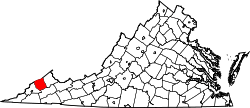 | |
| CDP | ||
| Unincorporated communities | ||
| Footnotes | ‡This populated place also has portions in an adjacent county or counties | |
This article is issued from Wikipedia - version of the 11/3/2016. The text is available under the Creative Commons Attribution/Share Alike but additional terms may apply for the media files.