Mead Township, Belmont County, Ohio
| Mead Township, Belmont County, Ohio | |
|---|---|
| Township | |
|
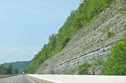
Cliffs along State Route 7 | |
 Location of Mead Township in Belmont County | |
| Coordinates: 39°57′32″N 80°47′22″W / 39.95889°N 80.78944°WCoordinates: 39°57′32″N 80°47′22″W / 39.95889°N 80.78944°W | |
| Country | United States |
| State | Ohio |
| County | Belmont |
| Area | |
| • Total | 32.0 sq mi (83.0 km2) |
| • Land | 31.9 sq mi (82.7 km2) |
| • Water | 0.2 sq mi (0.4 km2) |
| Elevation[1] | 1,066 ft (325 m) |
| Population (2010) | |
| • Total | 5,967 |
| • Density | 187/sq mi (72.2/km2) |
| Time zone | Eastern (EST) (UTC-5) |
| • Summer (DST) | EDT (UTC-4) |
| FIPS code | 39-48580[2] |
| GNIS feature ID | 1085780[1] |
Mead Township is one of the sixteen townships of Belmont County, Ohio, United States. The 2010 census found 5,967 people in the township.[3]
Geography
Located in the southeastern part of the county along the Ohio River, it borders the following townships:
- Pultney Township - northeast
- York Township - south
- Washington Township - southwest
- Smith Township - west
- Richland Township - northwest
Marshall County, West Virginia, lies across the Ohio River to the east.
Most of the village of Shadyside is located in northeastern Mead Township, along the Ohio River.
Name and history
Mead is the name of the mother of Col. David Lockwood, Revolutionary War veteran and pioneer settler.[4]
It is the only Mead Township statewide.[5]
Government
The township is governed by a three-member board of trustees, who are elected in November of odd-numbered years to a four-year term beginning on the following January 1. Two are elected in the year after the presidential election and one is elected in the year before it. There is also an elected township fiscal officer,[6] who serves a four-year term beginning on April 1 of the year after the election, which is held in November of the year before the presidential election. Vacancies in the fiscal officership or on the board of trustees are filled by the remaining trustees.
References
- 1 2 "US Board on Geographic Names". United States Geological Survey. 2007-10-25. Retrieved 2008-01-31.
- ↑ "American FactFinder". United States Census Bureau. Retrieved 2008-01-31.
- ↑ "Geographic Identifiers: 2010 Demographic Profile Data (G001): Mead township, Belmont County, Ohio". U.S. Census Bureau, American Factfinder. Retrieved February 18, 2014.
- ↑ McKelvey, A. T. (1903). Centennial History of Belmont County, Ohio, and Representative Citizens. Biographical Publishing Company. p. 298.
- ↑ "Detailed map of Ohio" (PDF). United States Census Bureau. 2000. Retrieved 2007-02-16.
- ↑ §503.24, §505.01, and §507.01 of the Ohio Revised Code. Accessed 4/30/2009.
External links
Municipalities and communities of Belmont County, Ohio, United States | ||
|---|---|---|
| Cities | 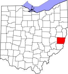 | |
| Villages | ||
| Townships | ||
| CDPs | ||
| Unincorporated communities |
| |
| Ghost town | ||
| Footnotes | ‡This populated place also has portions in an adjacent county or counties | |