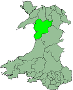
Meirionnydd
Coordinates: 52°45′29″N 3°50′06″W / 52.758°N 3.835°W
| Meirionnydd | |
|---|---|
 Flag of Merionethshire | |
 | |
| Population | |
| • 1971 | 29,531 |
| • 1992 (estimate) | 32,900 |
| History | |
| • Created | 1974 |
| • Abolished | 1996 |
| • Succeeded by | Gwynedd |
| Status | District |
| • HQ | Dolgellau |
Meirionnydd is a coastal and mountainous region of Wales. It has been a kingdom, a cantref, a district and, as Merionethshire, a county.
Kingdom
Meirionnydd (Meirion, with -ydd as a Welsh suffix of land, literally Land adjoined to Meirion) was a sub-kingdom of Gwynedd, founded according to legend by Meirion (or Marianus), a grandson of Cunedda,[1] a warrior-prince who brought his family to Wales from the 'Old North' (northern England and southern Scotland today), probably in the early 5th century. His dynasty seems to have ruled there for the next four hundred years. The kingdom lay between the River Mawddach and the River Dovey, spreading in a north-easterly direction.
Cantref
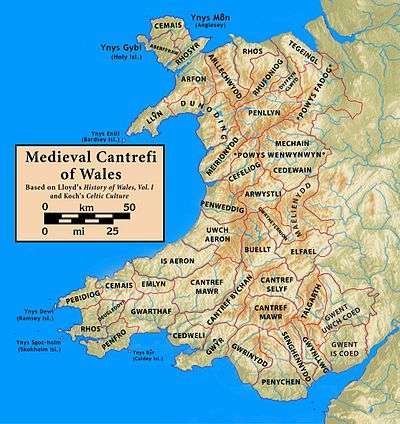
The ancient name of the cantref was Cantref Orddwy (or "the cantref of the Ordovices"). The familiar name coming from Meiron's kingdom.[1]
The cantref of Meirionnydd held the presumed boundaries of the previous kingdom but now as a fief of the Kingdom of Gwynedd where it continued to enjoy long spells of relative independence. It was divided into the commotes of Ystumanner (administered from Castell y Bere at Llanfihangel-y-Pennant) and Talybont (possibly centred on Llanegryn where there is a mound).[2] It was abolished in 1284 following the Statute of Rhuddlan and reorganised with the addition of some neighbouring cantrefi to form the county of Merionethshire.
County
The borders of Meirionnydd were expanded as a county (both historic and administrative) to include the old cantrefi of Penllyn and Ardudwy (shown as Dunoding in the map of medieval cantrefi). It took the name Merionethshire under English Law. In 1974 the administrative county was merged with those of Caernarfon and Anglesey to create a new Gwynedd.
District
Meirionnydd was one of five districts of Gwynedd from 1974 to 1996. The district comprised the majority of the administrative county of Merionethshire and reverted to the Welsh spelling of the county's name.
The district was created by the Local Government Act 1972, and replaced the following local government areas of Merionethshire:
- The urban districts of Bala, Barmouth, Dolgellau, Blaenau Ffestiniog and Tywyn
- The rural districts of Deudraeth, Dolgellau and Penllyn
Meirionnydd District was abolished in 1996 by the Local Government (Wales) Act 1994, becoming part of the unitary authority of 'Caernarfonshire and Merionethshire', which was immediately renamed Gwynedd as the first act of the new council. An area committee of Gwynedd Council now covers the area.
References
- 1 2 Lloyd, John Edward (1912). A History of Wales from the Earliest Times to the Edwardian Conquest. Longmans, Green, and Co. p. 250. Retrieved 16 April 2015.
- ↑ Lloyd, John Edward (1912). A History of Wales from the Earliest Times to the Edwardian Conquest. Longmans, Green, and Co. p. 252. Retrieved 16 April 2015.