Mewar
| Historical Region of Western India Mewar (मेवाड़) | |
| <div style="position:relative; margin: 0 0 0 0; border-collapse: collapse; border="1" cellpadding="0"> | |
| Location | Southern Rajasthan |
| 19th-century flag |  |
| Guhil State established: | AD 734 |
| Language | Mewari |
| Religion: | Hinduism |
| Dynasties | Moris (up to AD 734) Guhilots (734-1303) Sisodias (1326–1949) |
| Historical capitals | Nagda, Chittaurgarh, and Udaipur |
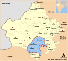
Mewar or Mewāḍ (Hindi: मेवाड़) is a region of south-central Rajasthan state in western India. It includes the present-day districts of Bhilwara, Chittorgarh, Rajsamand, Udaipur and some parts of Gujarat and Madhya Pradesh.
The region was for centuries a Rajput kingdom, the Mewar Kingdom or Udaipur Kingdom, that later became a princely state under the British.
It was originally called Medhpaat and Lord Shiva (Ekling Nath) is called Medhpateshwar (Lord of Medhpaat). Over time, the name Medhpath became Mewar. The Mewar region lies between the Aravali Range to the northwest, Ajmer to the north, Gujarat and the Vagad region of Rajasthan to the south, the Malwa region of Madhya Pradesh state to the southeast and the Hadoti region of Rajasthan to the east.
Geography
The northern part of Mewar is a gently sloping plain, drained by the Bedach and Banas River and its tributaries, which empty northwest into the Chambal River, a tributary of the Yamuna River. The southern part of the region is hilly, and marks the divide between the Banas and its tributaries and the headwaters of the Sabarmati and Mahi rivers and their tributaries, which drain south into the Gulf of Khambhat through Gujarat state. The Aravalli Range, which forms the northwestern boundary of the region, is composed mostly of sedimentary rocks, like marble and Kota Stone, which has traditionally been an important construction material.
The region is part of the Kathiawar-Gir dry deciduous forests' ecoregion. Protected areas include the Jaisamand Wildlife Sanctuary, the Kumbhalgarh Wildlife Sanctuary, the Bassi Wildlife Sanctuary and the Sita Mata Wildlife Sanctuary.
Mewar has a tropical climate. Rainfall averages 660 mm/year, and is generally higher in the southwest and lower in the northeast of the region. Over 90% of the rain typically falls in the period June to September every year, during the southwest monsoon.
History
.JPG)
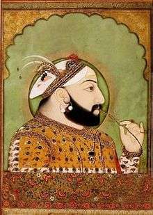

The Udaipur State, also known as Mewar Kingdom, was a princely state in India at the time of the British Raj.
The state of Mewar was founded around 530; later it would also, and ultimately predominantly, called Udaipur after the name of the capital. In 1568, Emperor Akbar conquered Chittorgarh, the capital of Mewar. It remained in Mughal hands for about 150 years. When Udaipur State joined the Indian Union in 1949 it had been ruled by the Chattari Rajputs of Mori, Guhilot and Sisodia dynasties for over 1,400 years.[3][4] Chittaurgarh was the capital of Sisodia clans of Rajputs of Mewar.
Title of Maharana
The Mewarian rulers used the title "Maharana" (Prime Minister or Custodian) instead of the typical title "Maharaja" (Great King or Emperor) as they merely believed themselves to be custodians of the Hindu civilization epitomized in the temple of Eklingji, a manifestation of Lord Shiva.
Economy
The economy of the Mewar region relies primarily on tourism, the marble and stone industry, mining, handicrafts, zinc smelters, cement and tyre factories, as well as agriculture. Major crops include maize, groundnut, soybean, wheat, and mustard. Opium is also grown in the adjoining regions of the southeast (Pratapgarh and Nimbahera). Fishery also thrives in the region's various lakes, supported by a government fisheries department.
Tourism

- The massive Chittorgarh hilltop fort is one of the main tourist attractions of Mewar. The fort is a depiction of Rajput culture and values. It stands on a 2.4 square kilometre site on an 180 m high hill that rises rapidly from the plains below. The fort was sacked thrice by a stronger enemy. The first sacking occurred in 1303 by Alauddin Khilji. In 1535 Bahadur Shah of Gujarat besieged the fort, causing the women to commit Jauhar. In 1568 Mughal emperor Akbar captured the fort.The war between the Mewar and mughal turned the fort to rubble but Akbar's dream to conquer the whole of Mewar never fulfilled.But it was not resettled by royal family again
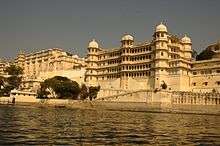
- Udaipur, also known as the city of lakes, is a world-famous and a very popular tourist destination with its grand palaces, lakes, temples, gardens and narrow lanes.
- The Lake Palace is a palace inaugurated in 1746, completely made of marble, and situated in the middle of Lake Pichola. In recent years Lake Pichola has experienced drought conditions.
- UnthalaGarh
- Jaisamand Lake
- Udaisagar lake
- Fatehsagar lake
- Shilpgram, a village northwest of Udaipur, hosts a crafts fair every year, which is one of the largest in India.
- Eklingji, a temple dedicated to Lord Shiva, the ruling deity of Mewar.
- Keshariaji, a temple of Rishabhdev.
- Nathdwara, a temple of Lord Shrinathji, one of the most important pilgrimage sites of India.
- Haldighati, a mountain pass in Rajsamand district that hosted the battle between Rana Pratap Singh and the Mughal emperor Akbar.
- Kumbhalgarh, a 15th-century fortress, built by Rana Kumbha, with 36 kilometres of walls. Over 360 temples are within the fort. It also has a wildlife sanctuary.
- Charbhuja Temple, dedicated to Lord Vishnu.
- Rajsamand, a huge lake near Rajsamand city, from which the city derives its name.
- The Ranakpur village is home to one of the most important Jain temples, which escaped the Mughal emperor Aurangzeb's efforts to destroy Hindu and Jain temples, because it is hidden in a geographically difficult terrain.
See also
Further reading
- Mewar through the ages, by D. L. Paliwal. Sahitya Sansthan, Rajasthan Vidyapeeth, 1970
- The Kingdom of Mewar: great struggles and glory of the world's oldest ruling dynasty, by Irmgard Meininger. D.K. Printworld, 2000. ISBN 81-246-0144-5.
- Costumes of the rulers of Mewar: with patterns and construction techniques, by Pushpa Rani Mathur. Abhinav Publications, 1994. ISBN 81-7017-293-4.
References
- ↑ Sen, Sailendra (2013). A Textbook of Medieval Indian History. Primus Books. pp. 116–117. ISBN 978-9-38060-734-4.
- ↑ John Merci, Kim Smith; James Leuck (1922). "Muslim conquest and the Rajputs". The Medieval History of India pg 67-115
- ↑ Princely States of India
- ↑ "Udaipur State (also called Mewar): History". The Imperial Gazetteer of India. 1909. pp. v. 24, p. 87.