Middlesex County, Ontario
| Middlesex County | |
|---|---|
| County (upper-tier) | |
| County of Middlesex | |
 Location of Middlesex County | |
 Municipalities of Middlesex County | |
| Coordinates: 43°00′N 81°30′W / 43.000°N 81.500°WCoordinates: 43°00′N 81°30′W / 43.000°N 81.500°W | |
| Country |
|
| Province |
|
| County seat | London |
| Municipalities | |
| Area[1] | |
| • Land | 2,824.47 km2 (1,090.53 sq mi) |
| • Census div. | 3,317.54 km2 (1,280.91 sq mi) |
| Population (2011)[1] | |
| • Total | 70,796 |
| • Density | 25.1/km2 (65/sq mi) |
| • Census div. | 439,151 |
| • Census div. density | 132.4/km2 (343/sq mi) |
| Time zone | EST (UTC-5) |
| • Summer (DST) | EDT (UTC-4) |
| Website | www.middlesex.ca |
Middlesex County (2011 population 70,796)[2] is a primarily rural county in Southwestern Ontario, Canada. Landlocked, the county is bordered by Huron and Perth counties on the north, Oxford County on the east, Elgin County on the south, and Chatham-Kent and Lambton County on the west.
The seat is the city of London, although the city is politically independent from the county. The Middlesex census division, which consists of the county together with the City of London and three Native reserves, had a population of 439,151 in 2011,[1] making it Canada's 16th largest. Part of the county is also included in the London census metropolitan area.
Subdivisions
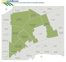
Middlesex County is composed of eight incorporated municipalities:
Townships and villages:
- Adelaide Metcalfe, Township
- Communities: Adelaide, Crathie, Dejong, Kerwood, Keyser, Mullifarry, Napier, Napperton, Springfield, Walkers and Wrightmans Corners.
- Lucan Biddulph, Township
- Communities: Biddulph, Clandeboye, Granton, Lucan.
- Middlesex Centre, Municipality of
- Communities: Arva, Ballymote, Birr, Bryanston, Coldstream, Delaware, Denfield, Duncrief, Elginfield, Ettrick, Ilderton, Ivan, Kilworth, Komoka, Littlewood, Lobo, Lobo Siding, Maple Grove, Melrose, Poplar Hill, Sharon, Southgate, Southwold, Telfer and Vanneck.
- Newbury, Village
- North Middlesex, Municipality of (township)
- Communities:Ailsa Craig, Beechwood, Bornish, Bowood, Brinsley, Carlisle, Corbett, Greenway, Hungry Hollow, Lieury, Moray, Mount Carmel, Nairn, Parkhill, Sable, Springbank, Sylvan and West McGillivray.
- Southwest Middlesex, Municipality of (township)
- Communities: Appin, Ekfrid, Glencoe, Lewis Corners, Macksville, Mayfair, Newbury Station, North Appin Station, North Ekfrid, North Glencoe Station, Riverside, Strathburn, Tate Corners, Wardsville and Woodgreen.
- Strathroy-Caradoc, Township of
- Communities: Cairngorm, Campbellvale, Caradoc, Christina, Falconbridge, Glen Oak, Longwood, Melbourne, Mount Brydges, Muncey and Strathroy.
- Thames Centre, Municipality of (township)
- Communities: Avon, Belton, Cherry Grove, Crampton, Cobble Hill, Derwent, Devizes, Dorchester, Evelyn, Fanshawe Lake, Friendly Corners, Gladstone, Harrietsville, Kelly Station, Mossley, Nilestown, Oliver, Plover Mills, Putnam, Salmonville, Silvermoon, Thorndale, Three Bridges and Wellburn.
First Nations reserves located within the Middlesex census division but separate from Middlesex County:
Demographics
Historic population:
- 2011: 70,796 (5-year growth rate: 2.6%)
- 2006: 69,024 (5-year growth rate: 3.6%)
- 2001: 66,646 (5-year growth rate: 4.2%)
- 1996: 63,947
The demographics below are for the Middlesex census division which includes the politically separate City of London and the three First Nations reserves.
| Canada census – Middlesex County, Ontario community profile | |||
|---|---|---|---|
| 2011 | 2006 | 2001 | |
| Population: | 439,151 (4.0% from 2006) | 422,333 (4.7% from 2001) | 403,185 (3.5% from 1996) |
| Land area: | 3,317.54 km2 (1,280.91 sq mi) | 3,317.15 km2 (1,280.76 sq mi) | 3,317.07 km2 (1,280.73 sq mi) |
| Population density: | 132.4/km2 (343/sq mi) | 127.3/km2 (330/sq mi) | 121.5/km2 (315/sq mi) |
| Median age: | 38.5 (M: 37.2, F: 39.8) | 36.8 (M: 35.6, F: 37.9) | |
| Total private dwellings: | 195,679 | 183,091 | 170,915 |
| Median household income: | |||
| Notes: Excludes census data for one or more incompletely enumerated Indian reserves – References: 2011[1] 2006[3] 2001[4] | |||
Former communities
The City of London, including the annexations below, is now politically independent from Middlesex County:
- Old London East (Formerly their own Incorporated town (Annexed by London 1885)
- Wortley Village (annexed by London in 1890)
- Petersville (Kensington) (annexed by London in 1897)
- Pottersburg (annexed by London about 1905; population increase was required to allow public transit to operate on Sunday).
- Byron (annexed by London in 1961)
- Broughdale (annexed by London in 1961)
- Masonville (annexed by London in 1961)
- Lambeth (annexed by London in 1993)
- Westminster (annexed by London in 1993)
- Glanworth (annexed by London in 1993)
- Hyde Park (annexed by London)
- Crumlin (annexed by London)
- Fanshawe (annexed by London)
- Brockley (annexed by London)
- Scottsville (annexed by London)
- Tempo
See also
References
- 1 2 3 4 "Middlesex County census profile". 2011 Census of Population. Statistics Canada. Retrieved 2012-03-28.
- ↑ Sum of the eight census subdivisions in Middlesex County from "Census Profile". 2011 Census of Population. Statistics Canada. Retrieved 2013-01-27.
- ↑ "2006 Community Profiles". Canada 2006 Census. Statistics Canada. March 30, 2011. Retrieved 2012-03-28.
- ↑ "2001 Community Profiles". Canada 2001 Census. Statistics Canada. February 17, 2012. Retrieved 2012-03-28.
External links
| Wikimedia Commons has media related to Middlesex County, Ontario. |
 |
Huron County | Perth County |  | |
| Lambton County | |
Oxford County | ||
| ||||
| | ||||
| Chatham-Kent (single-tier municipality) | Elgin County |