Mignon, Alabama
| Mignon, Alabama | |
|---|---|
| CDP | |
|
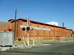
The Avondale Mills in Mignon | |
 Location in Talladega County and the state of Alabama | |
| Coordinates: 33°10′58″N 86°15′52″W / 33.18278°N 86.26444°W | |
| Country | United States |
| State | Alabama |
| County | Talladega |
| Area | |
| • Total | 2.6 sq mi (6.8 km2) |
| • Land | 2.6 sq mi (6.7 km2) |
| • Water | 0 sq mi (0.1 km2) |
| Elevation | 522 ft (159 m) |
| Population (2010) | |
| • Total | 1,284 |
| • Density | 490/sq mi (190/km2) |
| Time zone | Central (CST) (UTC-6) |
| • Summer (DST) | CDT (UTC-5) |
| FIPS code | 01-48616 |
| GNIS feature ID | 0144902 |
Mignon is a census-designated place (CDP) in Talladega County, Alabama, United States. At the 2010 census the population was 1,284.[1]
History
Mignon initially became an incorporated town (according to the 1920 U.S. Census) around 1915,[2] but either disincorporated or lost its charter in the 1930s and did not show on the 1940 U.S. Census. Because (as of 1950) it still was a sizeable community of 3,000 residents, it was listed on the 1950 through 1970 census rolls as an unincorporated community. Beginning in 1980, it received the new status of census-designated place (CDP).
Geography
Mignon is located at 33°10′59″N 86°15′52″W / 33.18306°N 86.26444°W (33.182929, -86.264456).[3]
According to the U.S. Census Bureau, the CDP has a total area of 2.6 square miles (6.8 km²), of which 2.6 square miles (6.7 km²) is land and 0.04 square mile (0.1 km²) (1.66%) is water.
Demographics
| Historical population | |||
|---|---|---|---|
| Census | Pop. | %± | |
| 1920 | 2,028 | — | |
| 1930 | 2,407 | 18.7% | |
| 1950 | 3,053 | — | |
| 1960 | 2,271 | −25.6% | |
| 1970 | 1,726 | −24.0% | |
| 1980 | 2,054 | 19.0% | |
| 1990 | 1,548 | −24.6% | |
| 2000 | 1,348 | −12.9% | |
| 2010 | 1,284 | −4.7% | |
| U.S. Decennial Census[4] | |||
As of the census[5] of 2000, there were 1,348 people, 550 households, and 365 families residing in the CDP. The population density was 480.4 people per square mile (185.2/km²). There were 640 housing units at an average density of 228.1 per square mile (87.9/km²). The racial makeup of the CDP was 76.19% White, 22.11% Black or African American, 0.52% Native American, 0.15% Asian, and 1.04% from two or more races. 0.52% of the population were Hispanic or Latino of any race.
There were 550 households out of which 28.7% had children under the age of 18 living with them, 44.5% were married couples living together, 16.5% had a female householder with no husband present, and 33.5% were non-families. 30.2% of all households were made up of individuals and 14.5% had someone living alone who was 65 years of age or older. The average household size was 2.45 and the average family size was 3.02.
In the CDP the population was spread out with 24.7% under the age of 18, 8.8% from 18 to 24, 28.6% from 25 to 44, 22.7% from 45 to 64, and 15.3% who were 65 years of age or older. The median age was 38 years. For every 100 females there were 94.2 males. For every 100 females age 18 and over, there were 88.7 males.
The median income for a household in the CDP was $21,019, and the median income for a family was $27,589. Males had a median income of $28,352 versus $19,375 for females. The per capita income for the CDP was $11,675. About 28.1% of families and 28.1% of the population were below the poverty line, including 48.1% of those under age 18 and 12.3% of those age 65 or over.
2010 census
As of the census[6] of 2010, there were 1,284 people, 507 households, and 330 families residing in the CDP. The population density was 490 people per square mile (190/km²). There were 628 housing units at an average density of 241.5 per square mile (93.7/km²). The racial makeup of the CDP was 64.9% White, 27.1% Black or African American, 0.1% Native American, 0.5% Asian, and 2.3% from two or more races. 6.9% of the population were Hispanic or Latino of any race.
There were 507 households out of which 27.2% had children under the age of 18 living with them, 37.7% were married couples living together, 19.3% had a female householder with no husband present, and 34.9% were non-families. 28.2% of all households were made up of individuals and 10.1% had someone living alone who was 65 years of age or older. The average household size was 2.53 and the average family size was 3.05.
In the CDP the population was spread out with 23.3% under the age of 18, 11.1% from 18 to 24, 27.5% from 25 to 44, 27.3% from 45 to 64, and 10.7% who were 65 years of age or older. The median age was 37.7 years. For every 100 females there were 95.1 males. For every 100 females age 18 and over, there were 105.6 males.
The median income for a household in the CDP was $30,682, and the median income for a family was $35,302. Males had a median income of $36,075 versus $13,750 for females. The per capita income for the CDP was $15,782. About 18.3% of families and 22.4% of the population were below the poverty line, including 25.8% of those under age 18 and 20.6% of those age 65 or over.
References
- ↑ "American FactFinder". United States Census Bureau. Retrieved 2011-05-14.
- ↑ https://books.google.com/books?id=WlVBAQAAMAAJ&pg=PA447&lpg=PA447&dq=%22mignon%22+%22alabama%22+%22incorporated%22+%221915%22&source=bl&ots=ZXv__rRGhR&sig=7tHU91BER6N6Z0MIb5mQ67O6Ies&hl=en&sa=X&ved=0ahUKEwi7vZOJqrjLAhUF5SYKHe-nBMMQ6AEIHDAA#v=onepage&q=%22mignon%22%20%22alabama%22%20%22incorporated%22%20%221915%22&f=false
- ↑ "US Gazetteer files: 2010, 2000, and 1990". United States Census Bureau. 2011-02-12. Retrieved 2011-04-23.
- ↑ "U.S. Decennial Census". Census.gov. Retrieved June 6, 2013.
- ↑ "American FactFinder". United States Census Bureau. Retrieved 2008-01-31.
- ↑ "American FactFinder". United States Census Bureau. Retrieved 2015-08-11.
Coordinates: 33°10′59″N 86°15′52″W / 33.182929°N 86.264456°W
Municipalities and communities of Talladega County, Alabama, United States | ||
|---|---|---|
| Cities | 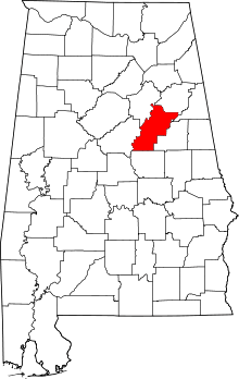 | |
| Towns | ||
| CDPs | ||
| Unincorporated communities | ||
| Ghost town | ||
| Footnotes | ‡This populated place also has portions in an adjacent county or counties | |