Milam, Texas
| Milam, Texas | |
|---|---|
| CDP | |
 Location of Milam, Texas | |
 | |
| Coordinates: 31°27′13″N 93°47′7″W / 31.45361°N 93.78528°WCoordinates: 31°27′13″N 93°47′7″W / 31.45361°N 93.78528°W | |
| Country | United States |
| State | Texas |
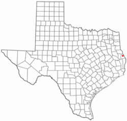
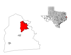
| County | Sabine |
| Area | |
| • Total | 33.4 sq mi (86.5 km2) |
| • Land | 32.8 sq mi (85.0 km2) |
| • Water | 0.6 sq mi (1.5 km2) |
| Elevation | 312 ft (95 m) |
| Population (2000) | |
| • Total | 1,329 |
| • Density | 40.5/sq mi (15.6/km2) |
| Time zone | Central (CST) (UTC-6) |
| • Summer (DST) | CDT (UTC-5) |
| ZIP codes | 75947, 75959 |
| Area code(s) | 409 |
| FIPS code | 48-48324[1] |
| GNIS feature ID | 1382282[2] |
Milam is a census-designated place (CDP) in Sabine County, Texas, United States. It is located at the junction of Highway 87 and Highway 21. The population was 1,480 at the 2010 census.
Geography
Milam is located at 31°27′13″N 93°47′7″W / 31.45361°N 93.78528°W (31.453492, -93.785384).[3]
According to the United States Census Bureau, the CDP has a total area of 33.4 square miles (87 km2), of which, 32.8 square miles (85 km2) of it is land and 0.6 square miles (1.6 km2) of it (1.71%) is water.
Historical development
With an approximate settling date of 1828, it was originally dubbed Red Mound, but would be renamed again in honor of Benjamin Rush Milam (a famous figure in the Texas Revolution) when it became the municipal seat of Sabine County eight years later, and remain so until 1858.[4] During the Civil War, the Confederate Army Quartermaster for the county would serve from this location.
Demographics
As of the census[1] of 2000, there were 1,329 people, 608 households, and 424 families residing in the CDP. The population density was 40.5 people per square mile (15.6/km²). There were 1,010 housing units at an average density of 30.8/sq mi (11.9/km²). The racial makeup of the CDP was 90.90% White, 7.07% African American, 0.45% Native American, 0.38% Asian, 0.08% Pacific Islander, 0.30% from other races, and 0.83% from two or more races. Hispanic or Latino of any race were 1.35% of the population.
There were 608 households out of which 17.6% had children under the age of 18 living with them, 61.8% were married couples living together, 4.9% had a female householder with no husband present, and 30.1% were non-families. 28.0% of all households were made up of individuals and 16.0% had someone living alone who was 65 years of age or older. The average household size was 2.19 and the average family size was 2.64.
In the CDP the population was spread out with 16.5% under the age of 18, 4.5% from 18 to 24, 17.4% from 25 to 44, 33.3% from 45 to 64, and 28.4% who were 65 years of age or older. The median age was 54 years. For every 100 females there were 98.7 males. For every 100 females age 18 and over, there were 99.6 males.
The median income for a household in the CDP was $32,717, and the median income for a family was $38,077. Males had a median income of $27,159 versus $26,397 for females. The per capita income for the CDP was $20,155. About 6.4% of families and 10.8% of the population were below the poverty line, including 6.1% of those under age 18 and 11.9% of those age 65 or over.
Education
Milam is served by the Hemphill Independent School District.
Climate
The climate in this area is characterized by hot, humid summers and generally mild to cool winters. According to the Köppen Climate Classification system, Milam has a humid subtropical climate, abbreviated "Cfa" on climate maps.[5]
References
- 1 2 "American FactFinder". United States Census Bureau. Retrieved 2008-01-31.
- ↑ "US Board on Geographic Names". United States Geological Survey. 2007-10-25. Retrieved 2008-01-31.
- ↑ "US Gazetteer files: 2010, 2000, and 1990". United States Census Bureau. 2011-02-12. Retrieved 2011-04-23.
- ↑ TSHA Online - Texas State Historical Association
- ↑ Climate Summary for Milam, Texas
External links
Municipalities and communities of Sabine County, Texas, United States | ||
|---|---|---|
| Cities | 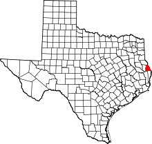 | |
| CDP | ||
| Unincorporated communities | ||
| Footnotes | ‡This populated place also has portions in an adjacent county or counties | |