Miller Township, Knox County, Ohio
| Miller Township, Knox County Ohio | |
|---|---|
| Township | |
|
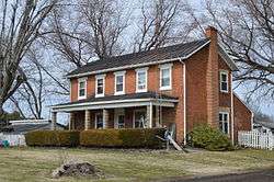
Farmhouse west of Brandon | |
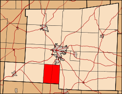 Location of Miller Township in Knox County. | |
| Coordinates: 40°17′58″N 82°30′26″W / 40.29944°N 82.50722°WCoordinates: 40°17′58″N 82°30′26″W / 40.29944°N 82.50722°W | |
| Country | United States |
| State | Ohio |
| County | Knox |
| Area | |
| • Total | 20.7 sq mi (53.7 km2) |
| • Land | 20.7 sq mi (53.7 km2) |
| • Water | 0.0 sq mi (0.0 km2) |
| Elevation[1] | 1,099 ft (335 m) |
| Population (2000) | |
| • Total | 893 |
| • Density | 43.1/sq mi (16.6/km2) |
| Time zone | Eastern (EST) (UTC-5) |
| • Summer (DST) | EDT (UTC-4) |
| FIPS code | 39-50330[2] |
| GNIS feature ID | 1086406[1] |
Miller Township is one of the twenty-two townships of Knox County, Ohio, United States. The 2000 census found 893 people in the township.[3]
Geography
Located in the southern part of the county, it borders the following townships:
- Clinton Township - north
- Pleasant Township - northeast
- Morgan Township - east
- Burlington Township, Licking County - south
- Bennington Township, Licking County - southwest corner
- Milford Township - west
- Liberty Township - northwest corner
No municipalities are located in Miller Township.
Name and history
Miller Township was named for James Miller, a pioneer settler who gave elections officials five and one half gallons of whiskey to secure the honor.[4] It is the only Miller Township statewide.[5]
Miller Township was originally built up chiefly by settlers from Vermont and Rhode Island.[6]
Government
The township is governed by a three-member board of trustees, who are elected in November of odd-numbered years to a four-year term beginning on the following January 1. Two are elected in the year after the presidential election and one is elected in the year before it. There is also an elected township fiscal officer,[7] who serves a four-year term beginning on April 1 of the year after the election, which is held in November of the year before the presidential election. Vacancies in the fiscal officership or on the board of trustees are filled by the remaining trustees.
References
- 1 2 "US Board on Geographic Names". United States Geological Survey. 2007-10-25. Retrieved 2008-01-31.
- ↑ "American FactFinder". United States Census Bureau. Retrieved 2008-01-31.
- ↑ Knox County, Ohio — Population by Places Estimates Ohio State University, 2007. Accessed 15 May 2007.
- ↑ Graham, Albert Adams (1881). History of Knox County, Ohio: Its Past and Present, Containing a Condensed, Comprehensive History of Ohio. A. A. Graham & Company. p. 522.
- ↑ "Detailed map of Ohio" (PDF). United States Census Bureau. 2000. Retrieved 2007-02-16.
- ↑ Kilbourn, John (1833). "The Ohio Gazetteer, or, a Topographical Dictionary". Scott and Wright. p. 315. Retrieved 12 December 2013.
- ↑ §503.24, §505.01, and §507.01 of the Ohio Revised Code. Accessed 4/30/2009.
External links
Municipalities and communities of Knox County, Ohio, United States | ||
|---|---|---|
| City |  | |
| Villages | ||
| Townships | ||
| CDPs | ||
| Unincorporated communities | ||
| Ghost town | ||
| Footnotes | ‡This populated place also has portions in an adjacent county or counties | |