Milton Township, Ashland County, Ohio
| Milton Township, Ashland County, Ohio | |
|---|---|
| Township | |
|
The Anderson Schoolhouse, built 1900 | |
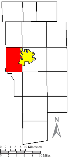 Location of Milton Township (red) adjacent to the city of Ashland (yellow) in Ashland County | |
| Coordinates: 40°51′5″N 82°22′31″W / 40.85139°N 82.37528°WCoordinates: 40°51′5″N 82°22′31″W / 40.85139°N 82.37528°W | |
| Country | United States |
| State | Ohio |
| County | Ashland |
| Area | |
| • Total | 22.7 sq mi (58.9 km2) |
| • Land | 22.7 sq mi (58.7 km2) |
| • Water | 0.08 sq mi (0.2 km2) |
| Elevation[1] | 1,260 ft (384 m) |
| Population (2010) | |
| • Total | 2,383 |
| • Density | 105/sq mi (40.6/km2) |
| Time zone | Eastern (EST) (UTC-5) |
| • Summer (DST) | EDT (UTC-4) |
| FIPS code | 39-50610[2] |
| GNIS feature ID | 1085709[1] |

Milton Township is one of the fifteen townships of Ashland County, Ohio, United States. As of the 2010 census the population was 2,383.[3]
Geography
Located in the western part of the county, it borders the following townships:
- Clear Creek Township - north
- Orange Township - northeast corner
- Montgomery Township - east
- Vermillion Township - southeast corner
- Mifflin Township - south
- Mifflin Township, Richland County - southwest corner
- Weller Township, Richland County - west
- Butler Township, Richland County - northwest corner
Part of the city of Ashland, the county seat of Ashland County, is located in eastern Milton Township.
Name and history
Milton Township was organized in 1816.[4]
It is one of five Milton Townships statewide.[5]
Government
The township is governed by a three-member board of trustees, who are elected in November of odd-numbered years to a four-year term beginning on the following January 1. Two are elected in the year after the presidential election and one is elected in the year before it. There is also an elected township fiscal officer,[6] who serves a four-year term beginning on April 1 of the year after the election, which is held in November of the year before the presidential election. Vacancies in the fiscal officership or on the board of trustees are filled by the remaining trustees.
References
- 1 2 "US Board on Geographic Names". United States Geological Survey. 2007-10-25. Retrieved 2008-01-31.
- ↑ "American FactFinder". United States Census Bureau. Retrieved 2008-01-31.
- ↑ "Geographic Identifiers: 2010 Demographic Profile Data (G001): Milton township, Ashland County, Ohio". U.S. Census Bureau, American Factfinder. Retrieved July 8, 2013.
- ↑ Baughman, Abraham J. (1909). History of Ashland County, Ohio, Volume 1. S. J. Clarke Publishing Company. p. 138.
- ↑ "Detailed map of Ohio" (PDF). United States Census Bureau. 2000. Retrieved 2007-02-16.
- ↑ §503.24, §505.01, and §507.01 of the Ohio Revised Code. Accessed 4/30/2009.
External links
Municipalities and communities of Ashland County, Ohio, United States | ||
|---|---|---|
| City | 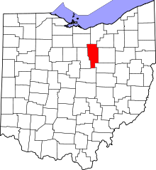 | |
| Villages | ||
| Townships | ||
| CDP | ||
| Unincorporated communities | ||
| Footnotes | ‡This populated place also has portions in an adjacent county or counties | |